Sungei Punggol
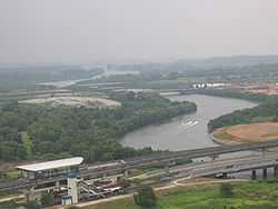
Sungei Punggol (Malay for Punggol River; Chinese: 榜鵝河; Pinyin: Bǎng'é Hé) is a river located within the North-East Region in Singapore.
Geography
Other than Punggol New Town, the river flows through 7 other towns in the late 1990s and early 2000s, much of the river banks along Sungei Punggol have since been reclaimed and the river canalised.
Future developments
To better serve the recreational needs of the residents of Sengkang New Town, a network of green connectors will be built along the banks of Sungei Punggol in future. These connectors would link the housing precincts to neighbourhood parks, the town park and a future sports complex in the new town. Eventually, these park connectors will also be linked to the future Coney Island Park in Punggol New Town and the existing Punggol Park in Hougang.
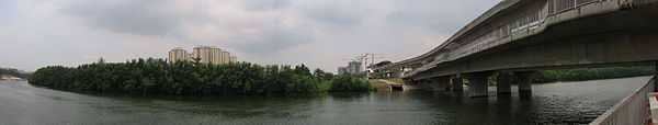
An artificial man-made floating island has been constructed in the middle of the river in the Sengkang part of the river.
Plans are underway to dam up the estuary of Sungei Punggol to form a reservoir, to be ready by 2011.[1]
Road bridges
The roads that span over Sungei Punggol include:
- Tampines Expressway
- Fernvale Street and Anchorvale Street
- Sengkang East Way and Sengkang West Way
- Sengkang East Avenue and Sengkang West Avenue
- Lorong Buang Kok
See also
References
- ↑ "The 1st National Tap". Public Utilities Board. Retrieved 17 December 2009.
| ||||||||||||||||||||||||||||||||||||||||||
Coordinates: 1°25′04″N 103°53′54″E / 1.41778°N 103.89833°E