Sulaimaniyah International Airport
| Sulaimaniyah International Airport Firokaxaney Nawdewletî Silêmanî / فڕۆکەخانەی نێودەوڵەتی سلێمانی مطار السليمانية الدولي | |||||||||||
|---|---|---|---|---|---|---|---|---|---|---|---|
 | |||||||||||
 | |||||||||||
 ISU | |||||||||||
| Summary | |||||||||||
| Operator | Kurdistan Regional Government | ||||||||||
| Serves | Sulaymaniyah, Iraq | ||||||||||
| Elevation AMSL | 760 ft / 232 m | ||||||||||
| Coordinates | 35°33′39″N 45°18′52″E / 35.56083°N 45.31444°E | ||||||||||
| Website | sul-airport.com | ||||||||||
| Runways | |||||||||||
| |||||||||||
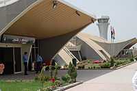
Sulaimaniyah International Airport (IATA: ISU, ICAO: ORSU) is an airport 15 kilometers outside of the city of Sulaimaniyah, in the Kurdistan region of Iraq. The airport has facilities for both cargo and passengers. Sulaimaniyah International Airport has three terminals for departures, arrivals and VIP. The construction of the airport began in November 2003, and it was inaugurated in July 2005.
Airlines and destinations
See also
References
- ↑ "Georgian Airways Interactive Map". Georgian Airways. Retrieved 15 September 2014.
- ↑ "Germania Flight Schedule / 30.12.2014 - 01.11.2015" (PDF). Germania.
- ↑ http://www.arabnews.com/news/445775
External links
- Sulaimaniyah International Airport
- Airport information for ORSU at World Aero Data. Data current as of October 2006.Source: DAFIF.
- Airport information for ISU at Great Circle Mapper. Source: DAFIF (effective Oct. 2006).
- Accident history for ISU at Aviation Safety Network