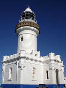
Sugarloaf Point Light
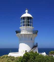 Sugarloaf Point Lighthouse | |
 | |
| Location | Seal Rocks, New South Wales, Australia |
|---|---|
| Coordinates | 32°26′27.45″S 152°32′21.25″E / 32.4409583°S 152.5392361°ECoordinates: 32°26′27.45″S 152°32′21.25″E / 32.4409583°S 152.5392361°E |
| Year first constructed | 1875 |
| Automated | 1987[1] |
| Construction | rendered brick |
| Tower shape | round, lantern, gallery, external spiral stairway |
| Markings / pattern | white |
| Height | 49 feet (15 m) |
| Focal height |
W. 258 feet (79 m) R. 240 feet (73 m) |
| Original lens | 1st order Chance Brothers Fresnel lens |
| Intensity | 780,000 cd |
| Range |
W. 25 nautical miles (46 km; 29 mi)[2] R. 14 nautical miles (26 km; 16 mi) |
| Characteristic |
Fl. W. 7.5s F. R. south |
| Admiralty number | K2776 |
| NGA number | 111-6048 |
| ARLHS number | AUS-155 |
Sugarloaf Point Light, also known as Seal Rocks Lighthouse, is an active lighthouse located on Sugarloaf Point, a point about 3 kilometres (1.9 mi) southeast of Seal Rocks, New South Wales, Australia. It guards Seal Rocks, a treacherous rock formation to the south. It is the first lighthouse designed by James Barnet.[3][4][5] It is also one of only two towers in Australia with an external stairway.[3][4]
History
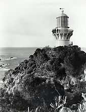
The first recorded recommendation for building a lighthouse to guard Seal Rocks was made by a committee of the New South Wales Legislative Assembly in 1863.[3] Original intentions were to place the lighthouse on the Rocks, but because of access difficulties the location finally chosen in 1873 was Sugarloaf Point.[3] The lighthouse was designed by James Barnet, the New South Wales Colonial Architect of the time. Tenders were called in 1874. Construction required building a 1,500 feet (460 m) long jetty, which was used to land the 1,800 tonnes (1,800 long tons; 2,000 short tons) of supplies and materials required for the construction.[4] Construction was completed in 1875 and the light was first lit on 1 December 1875.[3]
The original lens, still present, is a first order Chance Bros. sixteen-panel Fresnel lens dioptric.[3] The original light source was a kerosene lamp with a light intensity of 122,000 cd.[3] This was upgraded in April 1923 to a carbide lamp[4] with an intensity of 174,000 cd.[3]
In June 1966 the light was converted to electricity and the intensity raised to 1,000,000 cd.[3] and automated in 1987,[1] though a caretaker remained on the site until 2006-2007, when the residence was renovated to be used for tourist accommodations.[5] The last caretaker was Mark Sheriff, who was previously stationed in Green Cape Lighthouse.[6]
The current light is a 120 V 1,000 W quartz halogen lamp, powered by mains electricity with a backup diesel generator.[7] The light intensity is 780,000 cd,[4] and the light characteristic shown is flashing white with a cycle of 7.5 seconds. Also showing is an additional fixed red light, with a similar 120 V 1,000 W quartz halogen lamp,[4] visible to the south, over Seal Rocks and other dangers.[8] This secondary light is positioned at a lower height, and was originally green, changed to red in the 1980s.[3]
Structures
The lighthouse is built bricks, cement rendered, and painted white. The tower has two stories, divided by a concrete floor, the fuel store being located in the ground level. An outside bluestone stairway reaches this floor, followed by internal iron stairs. The total height to the lantern room is 6.7 metres (22 ft).[3]
On top of the tower is a bluestone gallery, the projecting part being supported by concrete corbels, a Barnet design hallmark. The gallery has an elegant black gunmetal railing, another Barnet hallmark. The lantern roof is a copper dome.[3]
A brick-paved walkway surrounds the base of the tower, enclosed by a 4 feet (1.2 m) high cement-rendered brick wall, painted white.[3]
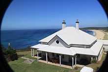
Near the lighthouse are the original Head Keeper's cottage and two semi-detached Assistant Keepers' cottages, designed by Barnet in 1875. The cottages were renovated in 2006 and are now used for overnight accommodations.[9]
North of the tower is a flag semaphore signal station. Next to it is the original concrete flagstaff base which retains some of the original iron fastenings. The flagstaff itself is recent.[3]
Other structures in the complex include a gabled roofed generator shed behind the Head Keeper's cottage, a painted brick workshop room behind the shed, a paint store to the north of the Assistant Keepers' cottages, and a garage.[10]
Site operation and visiting
The light is operated by the Australian Maritime Safety Authority, while the structures are maintained and operated by the Land and Property Management Authority. Sugarloaf Point is part of Myall Lakes National Park,[11] managed by the National Parks and Wildlife Service. An unpaved road leads to the location and parking is provided. Although the tower is closed to the public, a nearby lookout provides good views.
See also
Notes
- ↑ 1.0 1.1 According to Lighthouses of Australia Inc. Searle lists 1995. RNE103604 says 1997.
- ↑ According to List of Lights. RNE103604 says 22 nautical miles (41 km; 25 mi), though it might refer to an older light
- ↑ 3.0 3.1 3.2 3.3 3.4 3.5 3.6 3.7 3.8 3.9 3.10 3.11 3.12 3.13 RNE103604.
- ↑ 4.0 4.1 4.2 4.3 4.4 4.5 Lighthouse of Australia Inc.
- ↑ 5.0 5.1 Rowlett.
- ↑ Taylor 2000.
- ↑ According to Lighthouses of Australia Inc. RNE103604 says it is solar powered, but no sign of this can be seen on the structure
- ↑ List of Lights
- ↑ Accommodations.
- ↑ NSW Wildlife.
- ↑ Myall Lakes National Park.
References
- List of Lights, Pub. 111, The West Coasts of North and South America (Excluding Continental U.S.A. and Hawaii), Australia, Tasmania, New Zealand, and the Islands of the North and South Pacific Oceans (PDF). List of Lights. United States National Geospatial-Intelligence Agency. 2009. p. 123.
- Rowlett, Russ. "Lighthouses of Australia: New South Wales". The Lighthouse Directory. University of North Carolina at Chapel Hill. Retrieved 2010-08-29.
- "The Sugarloaf Point Lighthouse". Lighthouses of New South Wales. Lighthouses of Australia Inc.
- Searle, Garry. "Sugarloaf Point". Lighthouses of New South Wales. SeaSide Lights.
- "Sugarloaf Point Lighthouse (Commonwealth) (listing RNE103604)". Australia Heritage Places Inventory. Department of Sustainability, Environment, Water, Population and Communities. Retrieved 14 September 2010.
- "Supplementary Information Sugarloaf Point Lighthouse" (PDF). NSW National Parks and Wildlife Service.
- Taylor, Deborah (June 2000). "Mark Sheriff - The Heart of the Matter". Lighthouses of Australia Inc Bulletin (6).
- "Seal Rocks Lighthouse Holiday Accommodation". sealrockslighthouseaccommodation.com.au. Retrieved 14 September 2010.
- "DECCW - Myall Lakes National Park - Sugarloaf Point to Shelley Beach". environment.nsw.gov.au. Retrieved 14 September 2010.
Further reading
| Wikimedia Commons has media related to Sugarloaf Point Light. |
- Denise Shultz (March–April 2006). "The Sugarloaf Point Story". Lighthouses of Australia Inc Bulletin 9 (2).
- Marguerite & Nick Stephen (August 2001). "Marguerite & Nick Stephen's NSW Trip: Part 2". Lighthouses of Australia Inc Bulletin (8).
- Ian Clifford (January 2000). "Point Stephens and Sugarloaf Point Trip Report". Lighthouses of Australia Inc Bulletin (1).
| |||||||||||||||||||||||||
