Suez Canal
| Suez Canal | |
|---|---|
 | |
| Specifications | |
| Locks | None |
| Navigation authority | Suez Canal Authority |
| History | |
| Original owner | Suez Canal Company (Compagnie Universelle du Canal Maritime de Suez) |
| Construction began | 25 April 1859 |
| Date completed | November 1869 |
| Geography | |
| Branch(es) | The New Suez Canal |
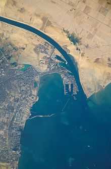
The Suez Canal (Arabic: قناة السويس Qanāt al-Suwais) is an artificial sea-level waterway in Egypt, connecting the Mediterranean Sea and the Red Sea. Opened in November 1869 after 10 years of construction, it allows ships to travel between Europe and South Asia without navigating around Africa thereby reducing the sea voyage distance between Europe and India by about 7,000 kilometres (4,300 mi). The northern terminus is Port Said; the southern terminus is Port Tewfik at the city of Suez. Ismailia is on its west bank, 3 km (1.9 mi) from the half-way point.[1] In 2012, 17,225 vessels traversed the canal (47 per day).[2]
When built, the canal was 164 km (102 mi) long and 8 m (26 ft) deep. After several enlargements, it is 193.30 km (120.11 mi) long, 24 m (79 ft) deep and 205 metres (673 ft) wide.[3] It consists of the northern access channel of 22 km (14 mi), the canal itself of 162.25 km (100.82 mi) and the southern access channel of 9 km (5.6 mi).[4]
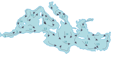
The canal is single lane with passing places in the "Ballah By-Pass" and the Great Bitter Lake.[5] It contains no locks; seawater flows freely through it. In general, the canal north of the Bitter Lakes flows north in winter and south in summer. The current south of the lakes changes with the tide at Suez.[6]
The canal is owned and maintained by the Suez Canal Authority[7] (SCA) of Egypt. Under the Convention of Constantinople, it may be used "in time of war as in time of peace, by every vessel of commerce or of war, without distinction of flag."[8]
In August 2014, construction was launched to construct a second canal for half of the route of the canal, costing $8.4 billion, to increase the canal's capacity. Funding was arranged by issuing interest-bearing investment certificates exclusively to Egyptian entities and individuals and the target amount was collected over only six working days. The expansion is expected to double the capacity of the Suez Canal from 49 to 97 ships a day. Construction of the project is expected to take a year.[9]
History

Nile–Red Sea Canal(s)
Ancient west–east canals were built to facilitate travel from the Nile river to the Red Sea.[10][11][12] One smaller canal is believed to have been constructed under the auspices of Senusret II[13] or Ramesses II.[10][11][12] Another canal, probably incorporating a portion of the first,[10][11] was constructed under the reign of Necho II, but the only fully functional canal was engineered and completed by Darius I.[10][11][12]
2nd millennium BC
The legendary Sesostris (likely either Pharaoh Senusret II or Senusret III of the Twelfth dynasty of Egypt[13][14]) is suggested to have perhaps started work on an ancient canal joining the Nile with the Red Sea (1897 BC–1839 BC). (It is said that in ancient times the Red Sea reached northward to the Bitter Lakes[10][11] and Lake Timsah.[15][16])
In his Meteorology, Aristotle wrote:
One of their kings tried to make a canal to it (for it would have been of no little advantage to them for the whole region to have become navigable; Sesostris is said to have been the first of the ancient kings to try), but he found that the sea was higher than the land. So he first, and Darius afterwards, stopped making the canal, lest the sea should mix with the river water and spoil it.[17]
Strabo wrote that Sesostris started to build a canal, and Pliny the Elder wrote:
165. Next comes the Tyro tribe and, on the Red Sea, the harbour of the Daneoi, from which Sesostris, king of Egypt, intended to carry a ship-canal to where the Nile flows into what is known as the Delta; this is a distance of over 60 miles. Later the Persian king Darius had the same idea, and yet again Ptolemy II, who made a trench 100 feet wide, 30 feet deep and about 35 miles long, as far as the Bitter Lakes.[18]
In the second half of the 19th century, French cartographers discovered the remnants of an ancient north–south canal past the east side of Lake Timsah and ending near the north end of the Great Bitter Lake.[19] This proved to be the celebrated canal made by the Persian king Darius I, as his stele commemorating its construction was found at the site. (This ancient, second canal may have followed a course along the shoreline of the Red Sea when it once extended north to Lake Timsah.[16][19]) In the 20th century the northward extension of this ancient canal was discovered, extending from Lake Timsah to the Ballah Lakes.[20] This was dated to the Middle Kingdom of Egypt by extrapolating the dates of ancient sites along its course.[20]
The reliefs of the Punt expedition under Hatshepsut 1470 BC depict seagoing vessels carrying the expeditionary force returning from Punt. This has given rise to the suggestion that a navigable link existed between the Red Sea and the Nile.[21][22] Evidence seems to indicate its existence by the 13th century BC during the time of Ramesses II.[10][23][24][25]
Canals dug by Necho, Darius I and Ptolemy
Remnants of an ancient west–east canal through the ancient Egyptian cities of Bubastis, Pi-Ramesses, and Pithom were discovered by Napoleon Bonaparte and his engineers and cartographers in 1799.[11][26][27][28][29]
According to the Histories of the Greek historian Herodotus,[30] about 600 BC, Necho II undertook to dig a west–east canal through the Wadi Tumilat between Bubastis and Heroopolis,[11] and perhaps continued it to the Heroopolite Gulf and the Red Sea.[10] Regardless, Necho is reported as having never completed his project.[10][11]
Herodotus was told that 120,000 men perished in this undertaking, but this figure is doubtlessly exaggerated.[31] According to Pliny the Elder, Necho's extension to the canal was about 57 English miles,[11] equal to the total distance between Bubastis and the Great Bitter Lake, allowing for winding through valleys that it had to pass through.[11] The length that Herodotus tells us, of over 1000 stadia (i.e., over 114 miles), must be understood to include the entire distance between the Nile and the Red Sea[11] at that time.
With Necho's death, work was discontinued. Herodotus tells us that the reason the project was abandoned was because of a warning received from an oracle that others would benefit by its successful completion.[11][32] In fact, Necho's war with Nebuchadnezzar II most probably prevented the canal's continuation.
Necho's project was completed by Darius I of Persia, who ruled over Ancient Egypt after it had been conquered by his predecessor Cambyses II.[33] We are told that by Darius's time a natural[11] waterway passage which had existed[10] between the Heroopolite Gulf and the Red Sea[34] in the vicinity of the Egyptian town of Shaluf[11] (alt. Chalouf[35] or Shaloof[16]), located just south of the Great Bitter Lake,[11][16] had become so blocked[10] with silt[11] that Darius needed to clear it out so as to allow navigation[11] once again. According to Herodotus, Darius's canal was wide enough that two triremes could pass each other with oars extended, and required four days to traverse. Darius commemorated his achievement with a number of granite stelae that he set up on the Nile bank, including one near Kabret, and a further one a few miles north of Suez. The Darius Inscriptions read:[36]
Saith King Darius: I am a Persian. Setting out from Persia, I conquered Egypt. I ordered this canal dug from the river called the Nile that flows in Egypt, to the sea that begins in Persia. When the canal had been dug as I ordered, ships went from Egypt through this canal to Persia, even as I intended.—Darius Inscription
The canal left the Nile at Bubastis. An inscription [37] on a pillar at Pithom records that in 270 or 269 BC it was again reopened, by Ptolemy II Philadelphus. In Arsinoe,[11] Ptolemy constructed a navigable lock, with sluices, at the Heroopolite Gulf of the Red Sea,[34] which allowed the passage of vessels but prevented salt water from the Red Sea from mingling with the fresh water in the canal.[38]
Receding Red Sea and the dwindling Nile
The Red Sea is believed by some historians to have gradually receded over the centuries, its coastline slowly moving southward away from Lake Timsah[15][16] and the Great Bitter Lake.[10][11] Coupled with persistent accumulations of Nile silt, maintenance and repair of Ptolemy's canal became increasingly cumbersome over each passing century.
Two hundred years after the construction of Ptolemy's canal, Cleopatra seems to have had no west–east waterway passage,[10][11] because the Pelusiac branch of the Nile, which had fed Ptolemy's west–east canal, had by that time dwindled, being choked with silt.[10][11]
Old Cairo to the Red Sea
By the 8th century, a navigable canal existed between Old Cairo and the Red Sea,[10][11] but accounts vary as to who ordered its construction—either Trajan or 'Amr ibn al-'As, or Omar the Great.[10][11] This canal reportedly linked to the River Nile at Old Cairo[11] and ended near modern Suez.[10][39] A geography treatise by Dicuil reports a conversation with an English monk, Fidelis, who had sailed on the canal from the Nile to the Red Sea during a pilgrimage to the Holy Land in the first half of the 8th century[40]
The Abbasid Caliph al-Mansur is said to have ordered this canal closed in 767 to prevent supplies from reaching Arabian detractors.[10][11]
Repair by Tāriqu l-Ḥākim
Al-Hakim bi-Amr Allah is claimed to have repaired the Cairo to Red Sea passageway,[10][11] but only briefly, circa 1000 AD,[10][11] as it soon "became choked with sand."[11] However, we are told that parts of this canal still continued to fill in during the Nile's annual inundations.[10][11]
Conception by Venice
The successful 1488 navigation of southern Africa by Bartolomeu Dias opened a direct maritime trading route to India and the spice islands, and forever changed the balance of Mediterranean trade. One of the most prominent losers in the new order, as former middlemen, was the former spice trading center of Venice.
| “ | Venetian leaders, driven to desperation, contemplated digging a waterway between the Red Sea and the Nile—anticipating the Suez Canal by almost 400 years—to bring the luxury trade flooding to their doors again. But this remained a dream. | ” |
| —Colin Thubron, Seafarers: The Venetians (1980), p. 102 | ||
Napoleon discovers an ancient canal
Napoleon Bonaparte's interest in finding the remnants of an ancient waterway passage[41] culminated in a cadre of archaeologists, scientists, cartographers and engineers scouring the area beginning in the latter months of 1798.[42] Their findings, recorded in the Description de l'Égypte, include detailed maps that depict the discovery of an ancient canal extending northward from the Red Sea and then westward toward the Nile.[41][43]
Napoleon had contemplated the construction of a north–south canal to join the Mediterranean and Red Sea, but this was abandoned after the preliminary survey erroneously concluded that the Red Sea was 10 metres (33 ft) higher than the Mediterranean, requiring locks that were too expensive and very long to construct. The error came from fragmented readings mostly done during wartime, which resulted in imprecise calculations.[44] Though by this time unnavigable,[11] the ancient route from Bubastis to the Red Sea still channeled water in spots as late as 1861[11] and as far east as Kassassin.
Mediterranean–Red Sea Canal
Interim period

Although the alleged difference in sea levels could be problematic for construction, the idea of finding a shorter route to the east remained alive. In 1830, F. R. Chesney submitted a report to the British government that stated that there was no difference in altitude and that the Suez Canal was feasible, but his report received no further attention. Lieutenant Waghorn established his 'Overland Route', which transported post and passengers to India via Egypt. Linant de Bellefonds, a French explorer of Egypt, became chief engineer of Egypt's Public Works. In addition to his normal duties, he surveyed the Isthmus of Suez and made plans for the Suez Canal. French Saint-Simonianists showed an interest in the canal and in 1833, Barthélemy Prosper Enfantin tried to draw Muhammad Ali's attention to the canal but was unsuccessful. Alois Negrelli, the Austrian railroad pioneer, became interested in the idea in 1836. In 1846, Prosper Enfantin's Société d'Études du Canal de Suez invited a number of experts, among them Robert Stephenson, Negrelli and Paul-Adrien Bourdaloue to study the feasibility of the Suez Canal (with the assistance of Linant de Bellefonds). Bourdaloue's survey of the isthmus was the first generally accepted evidence that there was no practical difference in altitude between the two seas. Britain, however, feared that a canal open to everyone might interfere with its India trade and therefore preferred a connection by train from Alexandria via Cairo to Suez, which was eventually built by Stephenson.
Construction by Suez Canal Company


In 1854 and 1856 Ferdinand de Lesseps obtained a concession from Sa'id Pasha, the Khedive of Egypt and Sudan, to create a company to construct a canal open to ships of all nations. The company was to operate the canal for 99 years from its opening. De Lesseps had used his friendly relationship with Sa'id, which he had developed while he was a French diplomat in the 1830s. As stipulated in the concessions, de Lesseps convened the International Commission for the piercing of the isthmus of Suez (Commission Internationale pour le percement de l'isthme des Suez) consisting of 13 experts from seven countries, among them John Robinson McClean, later President of the Institution of Civil Engineers in London, and again Negrelli, to examine the plans developed by Linant de Bellefonds, and to advise on the feasibility of and the best route for the canal. After surveys and analyses in Egypt and discussions in Paris on various aspects of the canal, where many of Negrelli's ideas prevailed, the commission produced a unanimous report in December 1856 containing a detailed description of the canal complete with plans and profiles.[45] The Suez Canal Company (Compagnie universelle du canal maritime de Suez) came into being on 15 December 1858 and work started on the shore of the future Port Said on 25 April 1859.
The excavation took some 10 years using forced labor (corvée) of Egyptian workers. Some sources estimate that over 30,000 people were working on the canal at any given period, that more than 1.5 million people from various countries were employed, and that thousands of laborers died.[46][47]
The British government had opposed the project from the outset to its completion. As one of the diplomatic moves against the canal, it disapproved of the use of "slave labor" of forced workers. The British Empire was the major global naval force and officially condemned the forced work and sent armed Bedouins to start a revolt among workers. Involuntary labor on the project ceased, and the viceroy condemned the corvée, halting the project.[48]
Angered by the British opportunism, de Lesseps sent a letter to the British government remarking on the British lack of remorse a few years earlier when forced workers died in similar conditions building the British railway in Egypt.
Initially international opinion was sceptical and Suez Canal Company shares did not sell well overseas. Britain, the United States, Austria, and Russia did not buy a significant number of shares.[49] All French shares were quickly sold in France. A contemporary British sceptic claimed:
| “ | One thing is sure... our local merchant community doesn't pay practical attention at all to this grand work, and it is legitimate to doubt that the canal's receipts... could ever be sufficient to recover its maintenance fee. It will never become a large ship's accessible way in any case.[50] | ” |
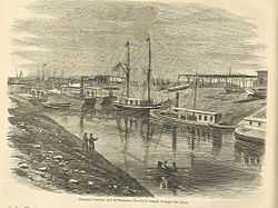

The canal opened under French control on 17 November 1869. Although numerous technical, political, and financial problems had been overcome, the final cost was more than double the original estimate. The opening was performed by Khedive Isma'il Pasha of Egypt and Sudan, and at Ismail's invitation French Empress Eugenie in the Imperial yacht Aigle piloted by Napoléon Coste, who was bestowed by the Khedive the Ottoman Order of the Medjidie. The first ship through the canal was the British P&O liner Delta.[51] Although L'Aigle was officially the first vessel through the canal, HMS Newport, captained by George Nares, passed through it first. On the night before the canal was due to open, Captain Nares navigated his vessel, in total darkness and without lights, through the mass of waiting ships until it was in front of L'Aigle. When dawn broke the French were horrified to find that the Royal Navy was first in line and that it would be impossible to pass them. Nares received both an official reprimand and an unofficial vote of thanks from the Admiralty for his actions in promoting British interests and for demonstrating such superb seamanship.[52]
After the opening the Suez Canal Company was in financial difficulties. The remaining works were completed only in 1871, and traffic was below expectations in the first two years. De Lesseps therefore tried to increase revenues by interpreting the kind of net ton referred to in the second concession (tonneau de capacité) as meaning a ship's cargo capacity and not only the theoretical net tonnage of the "Moorsom System" introduced in Britain by the Merchant Shipping Act in 1854. The ensuing commercial and diplomatic activities resulted in the International Commission of Constantinople establishing a specific kind of net tonnage and settling the question of tariffs in its protocol of 18 December 1873.[53] This was the origin of the Suez Canal Net Tonnage and the Suez Canal Special Tonnage Certificate still used.
The canal had an immediate and dramatic effect on world trade. Combined with the American transcontinental railroad completed six months earlier, it allowed the world to be circled in record time. It played an important role in increasing European colonisation of Africa. The construction of the canal was one of the reasons for the Panic of 1873, because goods from the Far East were carried in sailing vessels around the Cape of Good Hope and were stored in British warehouses. As sailing vessels were not adaptable for use through the canal, because the prevailing winds of the Mediterranean blow from west to east, British entrepôt trade suffered.[54] External debts forced Said Pasha's successor, Isma'il Pasha, to sell his country's share in the canal for £4,000,000 (about £85.9 million in 2014) to the United Kingdom in 1875, but French shareholders still held the majority. Prime Minister Benjamin Disraeli was accused by William Ewart Gladstone of undermining Britain's constitutional system, because he had not referred to, or obtained consent from Parliament when purchasing the shares with funding from the Rothschilds.[55]
The Convention of Constantinople in 1888 declared the canal a neutral zone under the protection of the British, who had occupied Egypt and Sudan at the request of Khedive Tewfiq to suppress the Urabi Revolt against his rule. The revolt went on from 1879 to 1882. As a result of British involvement on the side of Khedive Tewfiq, Britain gained control of the canal in 1882. The British defended the strategically important passage against a major Ottoman attack in 1915, during the First World War.[56] Under the Anglo-Egyptian Treaty of 1936, the UK retained control over the canal. In 1951 Egypt repudiated the treaty, and in October 1954 the UK agreed to remove its troops. Withdrawal was completed on 18 July 1956.
Suez Crisis
Because of Egyptian overtures towards the Soviet Union, the United Kingdom and the United States withdrew their pledge to support the construction of the Aswan Dam. Egyptian President Gamal Abdel Nasser responded by nationalizing the canal in 1956 and transferring it to the Suez Canal Authority, intending to finance the dam project using revenue from the canal. This led to the Suez Crisis, known in the Arab World as the "Tripartite Aggression", in which the UK, France, and Israel invaded Egypt. According to the pre-agreed war plans under the Protocol of Sèvres, the Israelis invaded the Sinai Peninsula, forcing Egypt to engage them militarily, and allowing the Anglo-French partnership to declare the resultant fighting a threat to the canal and enter the war on Israel's side.
To save the British from what he thought was a disastrous action and to stop the war from a possible escalation, Canadian Secretary of State for External Affairs Lester B. Pearson proposed the creation of the first United Nations peacekeeping force to ensure access to the canal for all and an Israeli withdrawal from the Sinai Peninsula. On 4 November 1956, a majority at the United Nations voted for Pearson's peacekeeping resolution, which mandated the UN peacekeepers to stay in Sinai unless both Egypt and Israel agreed to their withdrawal. The United States backed this proposal by putting pressure on the British government through the selling of sterling, which would cause it to depreciate. Britain then agreed to withdraw its troops. Pearson was later awarded the Nobel Peace Prize. As a result of damage and ships sunk under orders from Nasser the canal was closed until April 1957, when it was cleared with UN assistance.[57] A UN force (UNEF) was established to maintain the free navigability of the canal, and peace in the Sinai Peninsula.
According to the historian Abd aI-Azim Ramadan, Nasser's decision to nationalize the Suez Canal was his alone, made without political or military consultation. The events leading up to the nationalization of the Suez Canal Company, as other events during Nasser’s rule, showed Nasser’s inclination to solitary decision making. He considers Nasser to be far from a rational, responsible leader.[58]
Arab–Israeli wars of 1967 and 1973

In May 1967, president Gamal Abdel Nasser ordered the UN peacekeeping forces out of Sinai, including the Suez Canal area. Israel objected to the closing of the Straits of Tiran to Israeli shipping. The canal had been closed to Israeli shipping since 1949, except for a short period in 1951–1952.
After the 1967 Six Day War the canal was closed by an Egyptian blockade until 5 June 1975. As a result, 14 cargo ships known as the "Yellow Fleet" were trapped in the canal for over eight years.
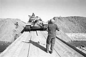
In 1973, during the Yom Kippur War, the canal was the scene of a major crossing by the Egyptian army into Israeli-occupied Sinai and a counter-crossing by the Israeli army to Egypt. Much wreckage from this conflict remains visible along the canal's edges. After the Yom Kippur War the United States initiated Operation Nimbus Moon. The amphibious assault ship USS Iwo Jima was sent to the Canal, carrying 12 RH-53D minesweeping helicopters of HM-12. These partly cleared the canal between May and December 1974. She was relieved by the LST USS Barnstable County (LST1197). The British Royal Navy initiated Operation Rheostat and Task Group 65.2 provided the minehunters HMS Maxton, HMS Bossington and HMS Wilton, and HMS Abdiel, a practice minelayer/MCMV support ship that spent two periods of 6 months in 1974 and in 1975 based at Ismailia. When the Canal Clearance Operations were completed, the canal and its lakes were considered 99% clear of mines. The canal was then reopened by Egyptian President Anwar Sadat aboard an Egyptian destroyer, which led the first convoy northbound to Port Said in 1975.[59]
The UNEF mandate expired in 1979. Despite the efforts of the United States, Israel, Egypt, and others to obtain an extension of the UN role in observing the peace between Israel and Egypt, as called for under the Egypt–Israel Peace Treaty of 1979, the mandate could not be extended because of the veto by the Soviet Union in the UN Security Council, at the request of Syria. Accordingly, negotiations for a new observer force in the Sinai produced the Multinational Force and Observers (MFO), stationed in Sinai in 1981 in coordination with a phased Israeli withdrawal. It is there under agreements between the United States, Israel, Egypt, and other nations.[60]
Canal layout and operation
Suez Canal map | ||||||||||||||||||||||||||||||||||||||||||||||||||||||||||||||||||||||||||||||||||||||||||||||||||||||||||||||||||||||||||||||||||||||||||||||||||||||||||||||||||||||||||||||||||||||||||||||||||||||||||||||||||||||||||||||||||||||||||||||||||||||||||||||||||||||||||||||||||||||||||||||||||||||||||||||||||||||||||||||||||||||||||||||||||||||||||||||||||||||||||||||||||||||||||||||||||||||||||||||||||||||
|---|---|---|---|---|---|---|---|---|---|---|---|---|---|---|---|---|---|---|---|---|---|---|---|---|---|---|---|---|---|---|---|---|---|---|---|---|---|---|---|---|---|---|---|---|---|---|---|---|---|---|---|---|---|---|---|---|---|---|---|---|---|---|---|---|---|---|---|---|---|---|---|---|---|---|---|---|---|---|---|---|---|---|---|---|---|---|---|---|---|---|---|---|---|---|---|---|---|---|---|---|---|---|---|---|---|---|---|---|---|---|---|---|---|---|---|---|---|---|---|---|---|---|---|---|---|---|---|---|---|---|---|---|---|---|---|---|---|---|---|---|---|---|---|---|---|---|---|---|---|---|---|---|---|---|---|---|---|---|---|---|---|---|---|---|---|---|---|---|---|---|---|---|---|---|---|---|---|---|---|---|---|---|---|---|---|---|---|---|---|---|---|---|---|---|---|---|---|---|---|---|---|---|---|---|---|---|---|---|---|---|---|---|---|---|---|---|---|---|---|---|---|---|---|---|---|---|---|---|---|---|---|---|---|---|---|---|---|---|---|---|---|---|---|---|---|---|---|---|---|---|---|---|---|---|---|---|---|---|---|---|---|---|---|---|---|---|---|---|---|---|---|---|---|---|---|---|---|---|---|---|---|---|---|---|---|---|---|---|---|---|---|---|---|---|---|---|---|---|---|---|---|---|---|---|---|---|---|---|---|---|---|---|---|---|---|---|---|---|---|---|---|---|---|---|---|---|---|---|---|---|---|---|---|---|---|---|---|---|---|---|---|---|---|---|---|---|---|---|---|---|---|---|---|---|---|---|---|---|---|---|---|---|---|---|---|---|---|---|---|---|---|---|---|---|---|---|---|---|---|---|---|---|---|---|---|---|---|---|---|---|---|---|---|---|---|---|---|---|---|---|---|---|---|---|---|---|
| ||||||||||||||||||||||||||||||||||||||||||||||||||||||||||||||||||||||||||||||||||||||||||||||||||||||||||||||||||||||||||||||||||||||||||||||||||||||||||||||||||||||||||||||||||||||||||||||||||||||||||||||||||||||||||||||||||||||||||||||||||||||||||||||||||||||||||||||||||||||||||||||||||||||||||||||||||||||||||||||||||||||||||||||||||||||||||||||||||||||||||||||||||||||||||||||||||||||||||||||||||||||
Capacity

The canal allows passage of ships up to 20 m (66 ft) draft or 240,000 deadweight tons and up to a height of 68 m (223 ft) above water level and a maximum beam of 77.5 m (254 ft) under certain conditions.[61][62] The canal can handle more traffic and larger ships than the Panama Canal. Some supertankers are too large to traverse the canal. Others can offload part of their cargo onto a canal-owned boat to reduce their draft, transit, and reload at the other end of the canal.
Navigation
The canal has no locks because of the flat terrain, and the minor sea level difference between each end is inconsequential for shipping. As the canal has no sea surge gates, the ports at the ends would be subject to the sudden impact of tsunamis from the Mediterranean Sea and Red Sea, according to a 2012 article in the Journal of Coastal Research.[63]
There is one shipping lane with passing areas in Ballah-Bypass near El Qantara and in the Great Bitter Lake. On a typical day, three convoys transit the canal, two southbound and one northbound. The passage takes between 11 and 16 hours at a speed of around 8 knots (15 km/h; 9 mph). The low speed helps prevent erosion of the banks by ships' wakes.
By 1955 about two-thirds of Europe's oil passed through the canal. Around 8% of world sea trade is carried via the canal. In 2008 21,415 vessels passed through the canal and the receipts totaled $5.381 billion,[61] with the average cost per ship of $251,000.
New Rules of Navigation came into force on 1 January 2008, passed by the board of directors of the Suez Canal Authority (SCA) to organise vessels' transit. The most important amendments include allowing vessels with 62-foot (19 m) draught to pass, increasing the allowed breadth from 32 metres (105 ft) to 40 metres (130 ft) (following improvement operations), and imposing a fine on vessels using divers from outside the SCA inside the canal boundaries without permission. The amendments allow vessels loaded with dangerous cargo (such as radioactive or flammable materials) to pass if they conform with the latest amendments provided by international conventions.
The SCA has the right to determine the number of tugs required to assist warships traversing the canal, to achieve the highest degree of safety during transit.[64]
Operation
The canal is too narrow for free two-way traffic, so ships pass in convoys and they use bypasses. The by-passes are 78 km (48 mi) out of 193 km (120 mi) (40%). From north to south, they are: Port Said by-pass (entrances) 36.5 km (23 mi), Ballah by-pass & anchorage, 9 km (6 mi), Timsah by-pass 5 km (3 mi), and the Deversoir by-pass (northern end of the Great Bitter Lake) 27.5 km (17 mi). The by-passes were completed in 1980.
Typically it takes a ship 12 to 16 hours to transit the canal. The canal's 24-hour capacity is about 76 standard ships.[65]
In August 2014, Egypt chose a consortium that includes the Egyptian army and global engineering firm Dar al-Handasah to develop an international industrial and logistics hub in the Suez Canal area,[66] and began the construction of a new Canal-Section combined with expansion and deep digging of the rest of the canal. This will allow navigation in both directions simultaneously. It is anticipated that these projects will be finished in August 2015.[9][67]
Convoy sailing
Since the canal does not cater for unregulated two-way traffic, all ships transit in convoys on regular times, scheduled on a 24-hour basis. Each day a single northbound convoy starts at 06.00 from Suez, getting an unhindered passage. At by-passes, the convoy uses the eastern route.[68] Interwoven in this convoy's passage are two southbound convoys. The first starts at 0.00 from Port Said, and anchors in the Great Bitter Lake to let the northbound pass; the second starts at 07.00 and anchors in the western Ballah by-pass to let the northbound convoy pass. Due to the Ballah canal dimensions, this convoy is restricted to smaller and often unloaded ships.
Canal crossings
From north to south, the crossings are:
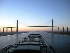
- The Suez Canal Bridge (30°49′42″N 32°19′03″E / 30.828248°N 32.317572°E), also called the Egyptian-Japanese Friendship Bridge, a high-level road bridge at El Qantara. In Arabic, al qantara means "arch". It has a 70-metre (230 ft) clearance over the canal and was built with assistance from the Japanese government and by Kajima.[69]
- El Ferdan Railway Bridge (30°39′25″N 32°20′02″E / 30.657°N 32.334°E) 20 km (12 mi) north of Ismailia (30°35′N 32°16′E / 30.583°N 32.267°E) was completed in 2001 and is the longest swing span bridge in the world, with a span of 340 m (1100 ft). The previous bridge was destroyed in 1967 during the Arab-Israeli conflict.
- Pipelines taking fresh water under the canal to Sinai, about 57 km (35 mi) north of Suez, at 30°27.3′N 32°21.0′E / 30.4550°N 32.3500°E.
- Ahmed Hamdi Tunnel (30°5′9″N 32°34′32″E / 30.08583°N 32.57556°E) south of the Great Bitter Lake (30°20′N 32°23′E / 30.333°N 32.383°E) was built in 1983. Because of leakage problems, a new water-tight tunnel[70] was built inside the old one from 1992 to 1995.
- The Suez Canal overhead powerline crossing (29°59′46″N 32°34′59″E / 29.996°N 32.583°E) was built in 1999.
A railway on the west bank runs parallel to the canal for its entire length.
Alternative routes
Cape Agulhas

The main alternative is around Cape Agulhas, the southernmost point of Africa, commonly referred as the Cape of Good Hope route. This was the only sea route before the canal was constructed, and when the canal was closed. It is still the only route for ships that are too large for the canal. In the early 21st century the long route has enjoyed increased popularity because of increasing piracy in Somalia.[71][72] Between 2008 and 2010, it is estimated that the canal lost 10% of traffic due to the threat of piracy, and another 10% due to the financial crisis. An oil tanker going from Saudi Arabia to the United States has 2,700 mi (4,345 km) longer to go when taking the route south of Africa rather than the canal.[73]
Before the canal's opening in 1869 goods were sometimes offloaded from ships and carried overland between the Mediterranean and the Red Sea.[74]
Northern Sea Route
In recent years, the shrinking Arctic sea ice has made the Northern Sea Route feasible for commercial cargo ships between Europe and East Asia during a six-to-eight-week window in the summer months, shortening the voyage by thousands of miles compared to that through the Suez Canal. According to polar climate researchers, as the extent of the Arctic summer ice pack recedes the route will become passable without the help of icebreakers for a greater period each summer.[75][76][77]
The Bremen-based Beluga Group claimed in 2009 to be the first Western company to attempt using the Northern Sea Route without assistance from icebreakers, cutting 4000 nautical miles off the journey between Ulsan, Korea and Rotterdam, the Netherlands.[78]
Negev desert railroad
Israel has declared that it will construct a railroad through the Negev desert to compete with the canal, with construction partly financed by China.[79]
Environmental impact

The opening of the canal created the first salt-water passage between the Mediterranean and the Red Sea. Although the Red Sea is about 1.2 m (4 ft) higher than the eastern Mediterranean,[80] the current between the Mediterranean and the middle of the canal at the Bitter Lakes flows north in winter and south in summer. The current south of the Bitter Lakes is tidal, varying with the tide at Suez.[6] The Bitter Lakes, which were hypersaline natural lakes, blocked the migration of Red Sea species into the Mediterranean for many decades, but as the salinity of the lakes gradually equalised with that of the Red Sea the barrier to migration was removed, and plants and animals from the Red Sea have begun to colonise the eastern Mediterranean. The Red Sea is generally saltier and more nutrient-poor than the Atlantic, so the Red Sea species have advantages over Atlantic species in the less salty and nutrient-rich eastern Mediterranean. Accordingly, most Red Sea species invade the Mediterranean biota, and only few do the opposite. This migratory phenomenon is called Lessepsian migration (after Ferdinand de Lesseps) or "Erythrean invasion". Also impacting the eastern Mediterranean, starting in 1968, was the operation of Aswan High Dam across the Nile. While providing for increased human development, the project reduced the inflow of freshwater and ended all natural nutrient-rich silt entering the eastern Mediterranean at the Nile Delta. This provided less natural dilution of Mediterranean salinity and ended the higher levels of natural turbidity, additionally making conditions more like those in the Red Sea.
Invasive species originated from the Red Sea and introduced into the Mediterranean by the canal have become a major component of the Mediterranean ecosystem and have serious impacts on the ecology, endangering many local and endemic species. About 300 species from the Red Sea have been identified in the Mediterranean, and there are probably others yet unidentified. The Egyptian government's intent to enlarge the canal has raised concerns from marine biologists, fearing that this will worsen the invasion of Red Sea species.[81]
Construction of the canal was preceded by cutting a small fresh-water canal called Sweet Water Canal from the Nile delta along Wadi Tumilat to the future canal, with a southern branch to Suez and a northern branch to Port Said. Completed in 1863, these brought fresh water to a previously arid area, initially for canal construction, and subsequently facilitating growth of agriculture and settlements along the canal.[82]
Timeline
- Circa 1799 – Napoleon Bonaparte conquers Egypt and orders a feasibility analysis. This reports a supposed 10-metre (33 ft) difference in sea levels and a high cost, so the project is put on hold.
- Circa 1840 – A second survey finds the first analysis incorrect. A direct link between the Mediterranean Sea and the Red Sea is possible and not as expensive as previously estimated.
- 30 November 1854 – The former French consul in Cairo, Ferdinand Marie de Lesseps, obtains the first license for construction and subsequent operation from the Viceroy for a period of 99 years.
- 6 January 1856 – de Lesseps is provided with a second, more detailed license.
 Container ship Hanjin Kaohsiung transiting the Suez Canal
 - 15 December 1858 – de Lesseps establishes the "Compagnie Universelle du Canal Maritime de Suez", with Said Pasha acquiring 22% of the Suez Canal Company; the majority is controlled by French private holders.
- 25 April 1859 – construction officially starts.
- 17 November 1869 – The canal is opened, owned and operated by Suez Canal Company.
- 18 December 1873 – The International Commission of Constantinople establishes the Suez Canal Net Ton and the Suez Canal Special Tonnage Certificate (as known today)
- 25 November 1875 – Britain becomes a minority share holder in the company, acquiring 44%, with the remainder being controlled by French business syndicates.
- 20 May 1882 – Britain invades Egypt, with French assistance, and begins its occupation of Egypt.
- 25 August 1882 – Britain takes control of the canal.
- 2 March 1888 – The Convention of Constantinople renews the guaranteed right of passage of all ships through the canal during war and peace; these rights were already part of the licenses awarded to de Lesseps, but are recognised as international law.
- 14 November 1936 – Following a new treaty, Britain theoretically pulls out of Egypt, but establishes the 'Suez Canal Zone' under its control.
_in_the_Suez_canal_1981.jpg) USS America (CV-66), an American aircraft carrier in the Suez Canal
USS America (CV-66), an American aircraft carrier in the Suez Canal - 13 June 1956 – Suez Canal Zone is restored to Egyptian sovereignty, following British withdrawal and years of negotiations.
- 26 July 1956 – Egypt nationalizes the company; its Egyptian assets, rights and obligations are transferred to the Suez Canal Authority, which compensates the previous owners at the established pre-nationalization price. Egypt closes the canal to Israeli shipping as part of a broader blockade involving the Straits of Tiran and the Gulf of Aqaba.
- 31 October 1956 to 24 April 1957 – the canal is blocked to shipping following the Suez Crisis, a conflict that leads to Israeli, and later French and British, occupation of the canal zone.
- 22 December 1956 – The canal zone is restored to Egyptian control, following French and British withdrawal, and the landing of UNEF troops.
- 5 June 1967 to 10 June 1975 – the canal is blocked by Egypt, following the war with Israel; it becomes the front line during the ensuing War of Attrition and the 1973 war, remaining closed to international shipping, until general agreement was near.
- 1 January 2008 – New rules of navigation passed by the Suez Canal Authority come into force.
Leadership
_-_TIMEA.jpg)
Presidents of the Suez Canal Company (1858–1956):
- Ferdinand de Lesseps (15 December 1858 – 7 December 1894)
- Jules Guichard (17 December 1892 – 17 July 1896) (acting for de Lesseps to 7 December 1894)
- Auguste-Louis-Albéric, prince d'Arenberg (3 August 1896 – 1913)
- Charles Jonnart (19 May 1913 – 1927)
- Louis de Vogüé (4 April 1927 – 1 March 1948)
- François Charles-Roux (4 April 1948 – 26 July 1956)
Chairmen of the Suez Canal Authority (1956–present):
- Doctor Mohamed Helmy Bahgat Badawy (26 July 1956 – 9 July 1957)
- Engineer Mahmoud Younis (10 July 1957 – 10 October 1965)
- Engineer Mashhour Ahmed Mashhour (14 October 1965 – 31 December 1983)
- Engineer Mohamed Ezzat Adel (1 January 1984 – December 1995)
- Admiral Ahmed Ali Fadel (22 January 1996 – Aug 2012)
- Admiral Mohab Mamish (2012 – present)
See also
References
- ↑ "Suez Canal guide". Marine Services Co. Retrieved 2 April 2010.
- ↑ "Yearly Number & Net Tone by Ship Type,Direction & Ship Status". Suez Canal. Retrieved Apr 23, 2014.
- ↑ "Canal Characteristics". Suez Canal Authority. 2010. Retrieved 2 April 2010.
- ↑ "Characteristics of the canal".
- ↑ Suez Canal Authority
- ↑ 6.0 6.1 The Red Sea Pilot. Imray Laurie Norie & Wilson. 1995. p. 266.
- ↑ "Official Web Site of the Suez Canal Authority".
- ↑ Constantinople Convention of the Suez Canal of 2 March 1888 still in force and specifically maintained in Nasser's Nationalization Act.
- ↑ 9.0 9.1 "New Suez Canal project proposed by Egypt to boost trade". Cairo News.Net. Retrieved 7 August 2014.
- ↑ 10.0 10.1 10.2 10.3 10.4 10.5 10.6 10.7 10.8 10.9 10.10 10.11 10.12 10.13 10.14 10.15 10.16 10.17 10.18 10.19 Encyclopaedia Britannica, 11th edition, s.v. "Suez Canal". Retrieved 8 August 2008.
- ↑ 11.0 11.1 11.2 11.3 11.4 11.5 11.6 11.7 11.8 11.9 11.10 11.11 11.12 11.13 11.14 11.15 11.16 11.17 11.18 11.19 11.20 11.21 11.22 11.23 11.24 11.25 11.26 11.27 11.28 11.29 11.30 Rappoport, S. (Doctor of Philosophy, Basel). History of Egypt (undated, early 20th century), Volume 12, Part B, Chapter V: "The Waterways of Egypt," pages 248–257. London: The Grolier Society.
- ↑ 12.0 12.1 12.2 Hassan, F. A. & Tassie, G. J. Site location and history (2003). Kafr Hassan Dawood On-Line, Egyptian Cultural Heritage Organization. Retrieved 8 August 2008.
- ↑ 13.0 13.1 Please refer to Sesostris#Modern research.
- ↑ J. H. Breasted attributes the ancient canal's early construction to Senusret III, up through the first cataract. Please refer to J. H. Breasted, Ancient Records of Egypt, Part One, Chicago 1906, §§642–648
- ↑ 15.0 15.1 The Columbia Encyclopedia, Sixth Edition, s.v. "Suez Canal". Retrieved 14 May 2008.
- ↑ "'''Meteorology''' (1.15)". Ebooks.adelaide.edu.au. 25 August 2010. Retrieved 24 August 2011.
- ↑ The Elder Pliny and John Healey Natural History (6.33.165) Penguin Classics; Reprint edition (5 February 2004) ISBN 978-0-14-044413-1 p.70
- ↑ 19.0 19.1 Carte hydrographique de l'Basse Egypte et d'une partie de l'Isthme de Suez (1855, 1882). Volume 87, page 803. Paris. See .
- ↑ 20.0 20.1 Shea, William H. "A Date for the Recently Discovered Eastern Canal of Egypt," in Bulletin of the American Schools of Oriental Research, No. 226 (April 1977), pp. 31–38.
- ↑ Sanford (1938), p.72; Garrison (1999), p.36.
- ↑ Recent excavations in Wadi Gawasis appear to indicate that Egypt's maritime trade started from the Red Sea and did not require a canal.
- ↑ Hess, Richard S. Rev. of Israel in Egypt: The Evidence for the Authenticity of the Exodus Tradition, by James K. Hoffmeier. The Denver Journal 1 (1 January 1998). Retrieved 14 May 2008.
- ↑ Hassan, Fekri A. Kafr Hassan Dawood On-line, 17 August 2003. Retrieved 14 May 2008.
- ↑ (Spanish) Martínez Babon, Javier. "Consideraciones sobre la Marinay la Guerra durante el Egipto Faraónico". Retrieved 14 May 2008.
- ↑ Descriptions de l'Égypte, Volume 11 (État Moderne), containing Mémoire sur la communication de la mer des Indes à la Méditerranée par la mer Rouge et l'Isthme de Sueys, par M. J.M. Le Père, ingénieur en chef, inspecteur divisionnaire au corps impérial des ponts et chaussées, membre de l'Institut d'Égypte, pp. 21–186
- ↑ Their reports were published in Description de l'Égypte
- ↑ Montet, Pierre. Everyday Life in the Days of Ramesses The Great (1981), page 184. Philadelphia: University of Pennsylvania Press.
- ↑ Silver, Morris. Ancient Economies II (6 April 1998), "5c. Evidence for Earlier Canals." ANCIENT ECONOMIES II. Retrieved 8 August 2008. Economics Department, City College of New York.
- ↑ Herodotus ii.158.
- ↑ "The figure ‘120,000’ is doubtless exaggerated. Mehemet Ali lost only 10,000 in making the Mahmûdieh Canal (from the Nile to Alexandria)." remarked W. W. How and J. Wells, A Commentary on Herodotus.
- ↑ According to Herodotus, work on the project was "stayed by a prophetic utterance that he [Necho] was toiling beforehand for the barbarian. The Egyptians call all men of other languages barbarians." (Herodotus, eo. loc..)
- ↑ Cambyses II (king of Persia) - Encyclopedia Britannica
- ↑ 34.0 34.1 Apparently, Ptolemy considered the Great Bitter Lake as a northern extension of the Red Sea, whereas Darius had not, because Arsinoe is located north of Shaluf. (See Naville, "Map of the Wadi Tumilat," referenced above.)
- ↑ Please refer to Darius the Great's Suez Inscriptions.
- ↑ Jona Lendering. "Darius' Suez Inscriptions". Livius.org. Retrieved 24 August 2011.
- ↑ Pithom Stele - translation of inscription
- ↑ R.E.Gmirkin, "Berossus and Genesis, Manetho and Exodus: Hellenistic Histories and the Date of the Pentateuch", p.236
- ↑ Petermann, A. Karte Der Bai Von Súes (1856). Nach der Engl. Aufnahme v. Comm. Mansell.
- ↑ Tuchman, Barbara Bible and Sword: How the British came to Palestine MacMillan, London (1987) ISBN 0-333-33414-0
- ↑ 41.0 41.1 Linda Hall Library, Kansas City, Missouri. The Search for the Ancient Suez Canal, accessed 20 August 2008.
- ↑ Please refer to Description de l'Égypte.
- ↑ Descriptions de l'Égypte, Volume 11 (État Moderne), containing Mémoire sur la communication de la mer des Indes à la Méditerranée par la mer Rouge et l'Isthme de Sueys, par M. J.M. Le Père, ingénieur en chef, inspecteur divisionnaire au corps impérial des ponts et chaussées, membre de l'Institut d'Égypte, pp. 21–186
- ↑ Wilson, The Suez Canal
- ↑ Percement de l'isthme de Suez. Rapport et Projet de la Commission Internationale. Documents Publiés par M. Ferdinand de Lesseps. Troisième série. Paris aux bureaux de l'Isthme de Suez, Journal de l'Union des deux Mers, et chez Henri Plon, Éditeur, 1856. On Google Books (french)
- ↑ Arnold. T. Wilson, The Suez Canal
- ↑ "Le canal de Suez – ARTE". Arte.tv. 13 August 2006. Retrieved 24 August 2011.
- ↑ Oster (2006)
- ↑ There are differing informations on the exact amounts
- ↑ (reported by German historian Uwe A. Oster)
- ↑ "The Suez Canal". Russojapanesewar.com. Retrieved 24 August 2011.
- ↑ "The People: Captain Nares". HMS Challenger. University of California, San Diego. Retrieved 30 May 2013.
- ↑ Protocol of the Commission (in french)
- ↑ The economic development of the American nation, p. 356, Reginald Charles McGrane, Ginn & Co., Boston 1950.
- ↑ Stephen J. Lee, Gladstone and Disraeli. Routledge, 107
- ↑ First World War – Willmott, H.P. Dorling Kindersley, 2003, Page 87
- ↑ The Other Side of Suez (documentary) – 2003
- ↑ Elie Podeh; Onn Winckler (1 December 2004). Rethinking Nasserism: Revolution and Historical Memory in Modern Egypt. University Press of Florida. pp. 105, 106. ISBN 978-0-8130-3137-8.
the prominent historian and commentator Abd al-Azim Ramadan, In a series of articles published in AlWafd, subsequently compiled in a hook published in 2000, Ramadan criticized the Nasser cult, …. The events leading up to the nationalization of the Suez Canal Company, as other events during Nasser’s rule, Ramadan wrote, showed Nasser to be far from a rational, responsible leader. … His decision to nationalize the Suez Canal was his alone, made without political or military consultation. … The source of all this evil. Ramadan noted, was Nasser’s inclination to solitary decision making… the revolutionary regime led by the same individual—Nasser— repeated its mistakes when it decided to expel the international peacekeeping force from the Sinai Peninsula and close the Straits of Tiran in 1967. Both decisions led to a state of war with Israel, despite the lack of military preparedness
- ↑ http://www.history.navy.mil/nan/backissues/1970s/1974/sep74.pdf
- ↑ (Multinational Force and Observers)
- ↑ 61.0 61.1 Suez Canal Authority http://www.suezcanal.gov.eg
- ↑ "Canal Characteristics". Suez Canal Authority. 2010. Retrieved 14 April 2010.
- ↑ Finkl, Charles W.; Pelinovsky, Efim; Cathcart, Richard B. (2012). "A Review of Potential Tsunami Impacts to the Suez Canal". Journal of Coastal Research 283: 745–759. doi:10.2112/JCOASTRES-D-12A-00002.1. ISSN 0749-0208.
- ↑ SC News
- ↑ "Traffic system". Egyptian Maritime Data Bank (EMDB). Retrieved 8 February 2013.
- ↑ http://ca.reuters.com/article/topNews/idCAKBN0G30HY20140803
- ↑ http://www.theguardian.com/world/2014/aug/05/egypt-build-new-suez-canal
- ↑ "Navigation, Convoy System". Suez Canal Authority. Retrieved 17 February 2013.
- ↑ "Kajima History". Kajima. Retrieved 23 March 2014.
- ↑ "Salt-Corroded Tunnel Undergoes Major Renovation". Kajima.co.jp. Retrieved 24 August 2011.
- ↑ Economic Impact of Piracy Hits Home – The New American
- ↑ Arab countries meet to tackle Somali pirate threat – The Christian Science Monitor
- ↑ Bowden, Anna et al. The Economic Cost of Maritime Piracy page 13. One Earth Future, December 2010. Retrieved 26 February 2011.
- ↑ Overland Mail by Thomas Fletcher Waghorn, Railway Alexandria – Cairo – Suez built by Robert Stephenson
- ↑ "The Final Frontier: The Northern Sea Route".
- ↑ "Bye pirates, hello Northeast Passage". AsianCorrespondent.com. 3 January 2010. Retrieved 29 May 2011.
- ↑ "Melting ice cap opens up Northeast Passage to British ships". Daily Mail. 12 September 2009. Retrieved 29 May 2011.
- ↑ "German vessels ready for the Northern Sea Route". BarentsObserver.com. 5 August 2009. Retrieved 21 September 2009.
- ↑ "(In Estonian) Israel builds a railroad between the Mediterranean and the Red sea". E24.ee. 5 February 2012.
- ↑ Madl, Pierre (1999). Essay about the phenomenon of Lessepsian Migration, Colloquial Meeting of Marine Biology I, Salzburg, April 1999 (revised in Nov. 2001).
- ↑ Galil and Zenetos (2002)
- ↑ Britannica (2007)
Sources
- Britannica (2007) "Suez Canal", in: The new Encyclopædia Britannica, 15th ed., 28, Chicago, Ill. ; London : Encyclopædia Britannica, ISBN 1-59339-292-3
- Galil, B.S. and Zenetos, A. (2002). "A sea change: exotics in the eastern Mediterranean Sea", in: Leppäkoski, E., Gollasch, S. and Olenin, S. (eds), Invasive aquatic species of Europe : distribution, impacts, and management, Dordrecht ; Boston : Kluwer Academic, ISBN 1-4020-0837-6, p. 325–336
- Garrison, Ervan G. (1999) A history of engineering and technology : artful methods, 2nd ed., Boca Raton, Fla. ; London : CRC Press, ISBN 0-8493-9810-X
- Karabell, Zachary (2003) Parting the Desert: The Creation of the Suez Canal, Knopf, ISBN 978-0-375-40883-0
- Oster, Uwe (2006) Le fabuleux destin des inventions : le canal de Suez, TV documentary produced by ZDF and directed by Axel Engstfeld (Germany)
- Rathbone, William (1882). Great Britain and the Suez Canal. London: Chapman and Hall, Limited.
- Sanford, Eva Matthews (1938) The Mediterranean world in ancient times, Ronald series in history, New York : The Ronald Press Company, 618 p.
- Pudney, John. Suez; De Lesseps' Canal. New York: Praeger, 1969. Print.
- Thomas, Hugh. Suez. [1st U.S ed.]. New York: Harper & Row, 1967. Print.
- Arrow, Sir Frederick. "A fortnight in Egypt at the opening of the Suez Canal", London : Smith and Ebbs, 1869.
External links
| Wikimedia Commons has media related to Suez Canal. |
- Suez Canal Authority website
- Plan of the Suez Canal — 1882
- Howstuffworks.com: Suez Canal article
- Panoramio.com: Suez Canal Photos
- Darius the Great's Suez Inscriptions
- Constantinople Convention of the Suez Canal, 1888
- Encyclopedia of the Orient: Suez Canal
- Entrance of the Suez Canal — 1882
- Suez Canal Container Terminal at Port Said
- Opening of the Suez Canal, 1869
- Bibliography on Water Resources and International Law Peace Palace Library
Coordinates: 30°42′18″N 32°20′39″E / 30.70500°N 32.34417°E
| ||||||||||||||||||||||||||||||||||||