Subdivisions of Nigeria
Main articles:
States of Nigeria, Local Government Areas of Nigeria and
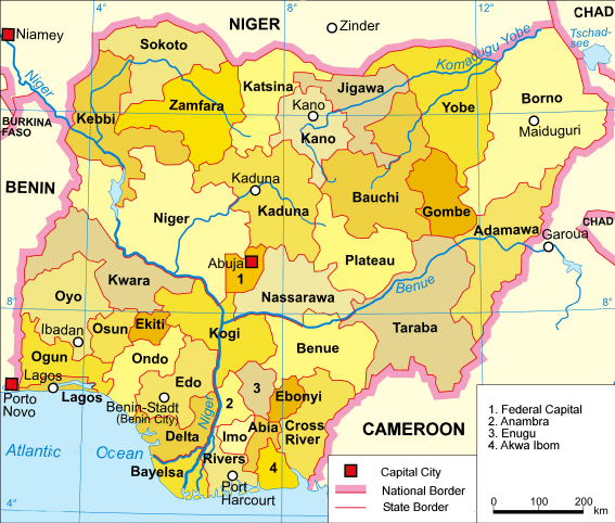
List of cities in NigeriaNigeria is divided into thirty-six states and one Federal Capital Territory, which are further sub-divided into 774 Local Government Areas (LGAs). The plethora of states, of which there were only three at independence, reflect the country's tumultuous history and the difficulties of managing such a heterogeneous national entity at all levels of government.
|
A clickable map of Nigeria exhibiting its 36 states and the federal capital territory.
|
References
Administrative divisions of Africa |
|---|
| | Sovereign states |
- Algeria
- Angola
- Benin
- Botswana
- Burkina Faso
- Burundi
- Cameroon
- Cape Verde
- Central African Republic
- Chad
- Comoros
- Democratic Republic of the Congo
- Republic of the Congo
- Djibouti
- Egypt
- Equatorial Guinea
- Eritrea
- Ethiopia
- Gabon
- The Gambia
- Ghana
- Guinea
- Guinea-Bissau
- Ivory Coast (Côte d'Ivoire)
- Kenya
- Lesotho
- Liberia
- Libya
- Madagascar
- Malawi
- Mali
- Mauritania
- Mauritius
- Morocco
- Mozambique
- Namibia
- Niger
- Nigeria
- Rwanda
- São Tomé and Príncipe
- Senegal
- Seychelles
- Sierra Leone
- Somalia
- South Africa
- South Sudan
- Sudan
- Swaziland
- Tanzania
- Togo
- Tunisia
- Uganda
- Zambia
- Zimbabwe
|
|---|
| |
- Sahrawi Arab Democratic Republic
- Somaliland
|
|---|
| |
- Canary Islands / Ceuta / Melilla / Plazas de soberanía (Spain)
- Madeira (Portugal)
- Mayotte / Réunion (France)
- Saint Helena / Ascension Island / Tristan da Cunha (United Kingdom)
- Western Sahara
|
|---|
|