Suðuroy
|
Location within Faroe Islands | |
| Geography | |
|---|---|
| Location | Faroe Islands |
| Coordinates | 61°32′N 6°51′W / 61.533°N 6.850°WCoordinates: 61°32′N 6°51′W / 61.533°N 6.850°W |
| Area | 163.7 km2 (63.2 sq mi) |
| Highest elevation | 610 m (2,000 ft) |
| Country | |
|
Kingdom of Denmark | |
| Constituent country | Faroe Islands |
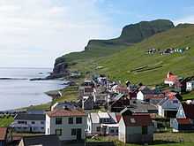
| Largest settlement | Tvøroyri |
| Demographics | |
| Population | 4678 (as of 2012) |


Suðuroy (literally South Island, Danish: Suderø) is the southernmost of the Faroe Islands. The island covers 163.7 square kilometres (63.2 sq mi). In 2012 there were 4,678 inhabitants, but there has been a gradual decline in the population numbers ever since the 1950s. In 2005 the population had been 5,036.
These are the settlements of Suðuroy (listed from north to south): Sandvík (re-established as a settlement in the early 19th century) Hvalba, Froðba, Tvøroyri, Trongisvágur, Øravík, Fámjin, Hov, Porkeri, Vágur, Fámara (re-established in 2010), Akrar, Lopra and Sumba.
One ancient settlement, Víkarbyrgi was abandoned late in the 1990s. Another settlement, Akraberg was abandoned around 1350 because of the black death; the people who lived there at that time came from Friesland, and legend has it that people in Hørg (in Sumba) can trace their ancestry back to this settlement, which was situated on the southernmost point of the island.
Two more settlements were started in the early and mid-20th century: Botni, north west of Vágur, and Tjaldavík, in a bay south east of Øravík. Both sites have been abandoned again.
Geography
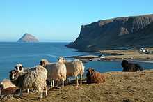
The highest point of Suðuroy is the mountain Gluggarnir (610 metres or 2,001 feet),[1] but the most famous peak is definitely the mountain of Beinisvørð north-west of the village of Sumba. The Beinisvørð and its scenery have been praised by the local poet Poul F. Joensen (1898–1970), as well as other Faroese poets. Suðuroy is the island which has the most islets and skerries. Suðuroy and the islets and skerries near the island number 263, including the island itself.[2] Suðuroy is also the only island of the 18 islands of the Faroes which has coalmines. One of them is still active. It is located in Hvalba, near the tunnel. There have been other coalmines in other places in Suðuroy as well: in Rangabotnur in Trongisvágur (on the south side of Trongisvágsfjørður) and in Fámjin.
Important Bird Area
The western side of the island has been identified as an Important Bird Area by BirdLife International because of its significance as a breeding site for seabirds, especially Northern Fulmars (100,000 pairs), European Storm Petrels (2500 pairs), European Shags (200 pairs), Black-legged Kittiwakes (39,000 pairs), Atlantic Puffins (20,000 pairs), Common Guillemots (31,900 individuals) and Black Guillemots (400 pairs).[3]
Tourism
Visitors to Suðuroy travel by the ferry MS Smyril from Tórshavn. The trip takes two hours. There are scenic views of nine of the total of eighteen islands that make up the Faroese archipelago. They are in the following order from north to south: Streymoy, Nólsoy, Hestur, Koltur, Sandoy, Skúvoy, Stóra Dímun, Lítla Dímun and Suðuroy.
As one travels past the two Dimun islands, the coastline of Suðuroy is in the background.
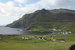
It is possible to go by bus from the harbour of Krambatangi. There are two bus lines; Line 701 goes towards north to Tvøroyri, Hvalba and Sandvík and to the west side of the island to Fámjin. The other buss line is line 700, which goes towards south to Vágur and all the other villages in the southern part of the island, Sumba being the southernmost and the terminus of route 700. The other villages, which line 700 passes by or through are: Øravík, Hov (just after the tunnel), Porkeri, Vágur, Lopra and finally Sumba.
From Tvøroyri there is an attractive walk across the mountains to a valley called Hvannhagi. There is a view over the valley and to Lítla Dímun and Stóra Dímun and the sea from above the valley. No roads lead to this valley.
By car, people can drive from Tvøroyri and follow the coast street over the mountains to Øravík and then there are three options. One can turn right to Fámjin, or one can continue straight ahead and take the tunnel to Hov, or take the old mountain road to Hov. After either of these two options, travel to Hov, and from there continue to the villages of Porkeri, Nes, Vágur, Lopra, Akrar and from Lopra, either take the road tunnel to Sumba or take the old curvy mountain road, which passes by the sea cliff Beinisvørð (400 meters above sea level), then continue to Akraberg with the lighthouse and to the southernmost village Sumba.
Vágseiði, Eggjarnar and Lopranseiði

From Vágur, there is the main road which continues towards west to Vágseiði, a scenic place with 200-metre-high (660 ft) cliffs towards south, but the road is only a few meters above sea level, and visitors can walk down a path, which used to be a boat harbour, and from there watch the sea, which often is a bit rough, and the cliff Skúvanes, the scerries Heltnarnar and the cliff Múlatangi. But it is worth a visit. From Vágur, visitors can also drive or walk along a road which is called Eggjarvegur, which leads to Eggjarnar, then find the road on the southern side of the fjord, shortly after a Magn petrol station to the right. In most places the road only has one lane and meeting spaces along the road. The road goes up the mountain, it has white painted stones along the road, so it is easy to spot on a distance. When visitors arrive up where the road ends, they will be only 25 m (82 ft) from the edge, and stand 200 m (660 ft) on a vertical cliff with a view towards Beinisvørð in the south and to Vágseiði in the north. On Eggjarnar, visitors can find two concrete bunkers which were view points during the World War II. There is also an abandoned former Loran-C station, as it closed down in the mid-1970s. Visitors can walk around on Eggjarnar and then drive back again, or if on foot, can continue towards the south, if it is not too foggy, to the isthmus of Lopra, Lopranseiði, which is not quite as high above the sea as Eggjarnar, only around 50 metres (160 ft) or so. Here visitors can see an islet called Lopranshólmur. Visitors will also see vertical cliffs here and a view to Beinisvørð. Between Lopranseiði and Beinisvørð there are some scerries, where the Dutch ship SS Westerbeek went shipwreck in 1742. Eighty-four men were on board, three died when the ship crashed, one fell down while trying to climb the cliff, but eighty men survived. They had to climb up the vertical cliff in order to survive, they found a place on the cliff where they could stand, they climbed from the ship to the cliff by the broken mast.
Fámjin

As mentioned above, one can also turn right from the village Øravík and follow the road over the mountain to the little village Fámjin, which is one of two villages on the west coast of Suðuroy, Sumba is the other one. All the other villages are located on the east coast. Fámjin is a charming village with a special reef in the middle of the bay, which close the bay at low tide, except for a sailing channel made by men in order for fishing boats to be able to go fishing. The small fishing harbour is inside this reef. There is a lake just above the village, called Kirkjuvatn, the path starts near the church. Another attraction in Fámjin are the cliffs and gorge west of the village, called Prestgjógv (Priest Gorge). The main attraction of Fámjin however is the original Faroese flag, Merkið, which is hanging inside of the church. It was made in 1919, by some Faroese students who studied in Copenhagen. One of them was Jens Oliver Lisberg from Fámjin. The flag was not recognized as the official flag of the Faroe Islands until World War II, when the Faroes were occupied by the British and Denmark by Germany, and therefor the islands needed their own flag during that period, but since then, the Merkið has been the official flag of the Faroe Islands. Inside the church of Fámjin is also the Fámjin stone, a Runestone with runic inscriptions.
The road between Øravík and Hov
There is a road tunnel between Øravík and Hov, as mentioned above, it opened in 2007. If visitors are in a hurry they can take the tunnel, but the road over the mountain is a beautiful trip, especially on the way back again to the ferry, with a nice view over the fjords Tjaldavík with Tjaldavíksholmur and Trongisvágsfjørður with the villages/towns Froðba, Tvøroyri and Trongisvágur lying around it.
Jóansøka - The Midsummer Festival of Suðuroy
Tvøroyri and Vágur take turns in hosting an annual civic-festival called Jóansøka. It can be described as a smaller version of the Ólavsøka held in Tórshavn. It runs in late June, in the last weekend of June, the rowing competition is always on Saturday of the Jóansøka weekend.
Sports in Suðuroy


Football in Suðuroy
The oldest sports club in the Faroe Islands, the football club Tvøroyrar Bóltfelag (TB) was founded in Tvøroyri on May 13, 1892, and is thereby the 9th oldest football club in the Danish Kingdom. There were three other football clubs in Suðuroy: Vágs Bóltfelag, (VB), Royn from Hvalba and the football club from Sumba, but VB Vágur and Sumba merged in 2005 to VB/Sumba (a similar merger under the name Sumba/VB had been attempted in the 1995 season but it lasted only this one season). On January 1, 2010 a new football club has been founded in Suðuroy, it is called FC Suðuroy and currently consists of the prior VB/Sumba.
TB Tvøroyri currently (2013) competes in the best Faroese football division; FC Suðuroy plays in the second best division. Both TB Tvøroyri and VB Vágur have won the Faroese National Championship (TB seven times, the last being in 1987, and VB once in the year 2000); but since the success is lacking in recent years, there is a growing debate about merging the four teams into one, (VB and Sumba have, as mentioned above, already joined forces since 2005). Royn Hvalba is playing in 3rd division in 2013.
Swimming in Suðuroy
Suðuroy has recently had good results in international swimming competitions. The two swimming clubs in Suðuroy "Vágs Svimjifelag" and "Tvøroyrar Svimjifelag" joined forces 6 September 2007 and founded Susvim, which is for the whole island. A young man from Vágur has had the best results until now. Pál Joensen won triple gold in the 2008 European Junior Swimming Championships on the short course in the men's 400 M, 800 M and 1500 M Freestyle. Two years later he won silver in the Men's 1500 M Freestyle at the 2010 European Aquatics Championships.[4] Other swimmers from Susvim have also had good results in Faroe Islands and in Denmark and other countries and at the Island Games competitions.
Rowing in Suðuroy
There are two active rowing clubs in Suðuroy, Vágs Kappróðrarfelag from Vágur and Froðbiar Sóknar Róðrarfelag from Tvøroyri and the villages around Trongisvágsfjørður (fjord). There are also rowing clubs in Sumba and in Hvalba. In Sumba they had a boat which was called Broddur, but they have not been active for some years now. In Hvalba they had a boat which was named Snopprikkur after a well-known man from the history of Suðuroy (Suðuroyar Sagnir). Vágs Kappróðrarfelag has these boats: Royndin Fríða, which is a so-called 5-mannafar, Smyril, which is a 6-mannafar, and Toftaregin, which is an 8-mannafar and Vágbingur, which is a 10-mannafar. Froðbiar Sóknar Róðrarfelag has the boats Firvaldur, which is a 5-mannafar (Firvaldur means Butterfly), Firildur and Hulda are also 5-mannafar, Tvørábáturin is a 6-mannafar, Suðringur and another Tvørábáturin are 10-mannafar (there are two boats which are called Tvørábáturin, which means the boat from Tvøroyri).[5]
Gallery
-

Stamp with Erik Christensens photo Lighthouse Akraberg.
-

Lighthouse Akraberg build 1909.
-

North of Akraberg
-

The westcoast between Beinisvørð and Vágur
-

Hov with Borgaknappur in the background.
-

Tvøroyri
-
Hvalba and Lítla Dímun
-

Glyvrabergsgjógv, west of Sandvík
-

Ásmundarstakkur west of Sandvík
-

M/F Smyril, the ferry between Suðuroy and Torshavn.


Notes
- ↑ us.fo
- ↑ US.fo
- ↑ BirdLife International. (2012). Important Bird Areas factsheet: Suduroy. Downloaded from http://www.birdlife.org on 2012-02-24.
- ↑ Swimmingworldmagazine.com
- ↑ Drekin.fo
Sources
- Hagstova.fo, Faroe Islands Statistics
- Susvim
External links
| Wikimedia Commons has media related to Suðuroy. |
- Visitsuduroy.fo, General travel information about Suðuroy
- Sudurras.com, Suðurrás The News Portal of Suðuroy
- SSL.fo, Time schedule of Smyril the Suðuroy ferry and busses
- Smyril - The ferry to Suðuroy
- Painting Courses in Suðuroy
- Art Gallery Oyggin
- Ruth Smith Art Museum
- Photos on Flickr tagged with Suðuroy.
| Look up Suðuroy in Wiktionary, the free dictionary. |
| ||||||||