Sturge Island
 Sturge Island is the southernmost of the Balleny Islands | |
 Location in Antarctica | |
| Geography | |
|---|---|
| Location | Antarctica |
| Coordinates | 67°25′S 164°44′E / 67.417°S 164.733°ECoordinates: 67°25′S 164°44′E / 67.417°S 164.733°E |
| Archipelago | Balleny Islands |
| Length | 37 km (23 mi) |
| Width | 9 km (5.6 mi) |
| Highest elevation | 1,705 m (5,594 ft) |
| Highest point | Brown Peak[1][2] |
| Country | |
|
None | |
| Demographics | |
| Population | 0 |
| Additional information | |
| Administered under the Antarctic Treaty System | |
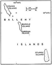
Sturge Island (67°25′S 164°44′E / 67.417°S 164.733°E) is one of the three main islands in the uninhabited Balleny Islands group located in the Southern Ocean. It lies 25 kilometres (16 mi) southeast of Buckle Island and 95 kilometres (59 mi) northeast of Belousov Point on the Antarctic mainland. The islands were discovered by John Balleny in 1839.
The island is roughly a parallelogram in shape, with long east and west coasts and shorter coasts facing northwest and southeast. It is approximately 5 nautical miles (5.8 mi) in width, and its maximum length is 20 nautical miles (23 mi),[3] between Cape Freeman in the north and Cape Smyth in the south.
The island's highest point reaches 1,705 m (5,594 ft)[1] or 1,524 m (5,000 ft)[2] (the unclimbed Brown Peak). This is the highest point in the Balleny chain.
The island forms part of the Ross Dependency, claimed by New Zealand (see claims on Antarctica).
See also
- Composite Antarctic Gazetteer
- List of Antarctic and sub-Antarctic islands
References
- LeMasurier, W. E.; Thomson, J. W. (eds.) (1990). Volcanoes of the Antarctic Plate and Southern Oceans. American Geophysical Union. pp. 512 pp. ISBN 0-87590-172-7.
- ↑ 1.0 1.1 Brown Peak, Composite Gazetteer of Antarctica, Scientific Committee on Antarctic Research. US source.
- ↑ 2.0 2.1 Brown Peak, Composite Gazetteer of Antarctica, Scientific Committee on Antarctic Research. NZ source.
- ↑ U.S. Geological Survey Geographic Names Information System: Sturge Island
![]() Media related to Balleny Islands at Wikimedia Commons
Media related to Balleny Islands at Wikimedia Commons