Stubai Alps
| Stubai Alps | |
|---|---|
|
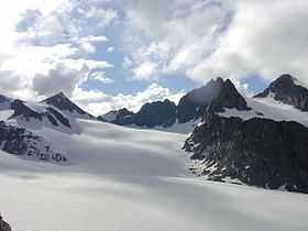
Lisenser FernerKogel, Rotgratspitze and Lisenser Spitze in July | |
| Highest point | |
| Peak | Zuckerhütl |
| Elevation | 3,507 m (11,506 ft) |
| Coordinates | 46°57′42″N 11°9′13″E / 46.96167°N 11.15361°E |
| Geography | |
| Countries | Austria and Italy |
| States | Tyrol and South Tyrol |
| Range coordinates | 47°05′N 11°10′E / 47.08°N 11.17°ECoordinates: 47°05′N 11°10′E / 47.08°N 11.17°E |
| Parent range | Central Eastern Alps |
The Stubai Alps (in German Stubaier Alpen; in Italian Alpi dello Stubai) is a mountain range in the Central Eastern Alps of Europe. It is named after the Stubaital valley to its east. It is located southwest of Innsbruck, Austria, and several summits of the range form part of Austria's border with Italy. The range is bounded by the Inn River valley to the north; the Sill River valley (Wipptal) and the Brenner Pass to the east (separating it from the Zillertal Alps); the Ötztal and Timmelsjoch to the west (separating it from the Ötztal Alps), and to the south by tributaries of the Passer River and Eisack.
Peaks
The ten highest peaks in the Stubai Alps are:
- Zuckerhütl, 3,507 m
- Schrankogel, 3,497 m
- Pfaffenschneide, 3,498 m
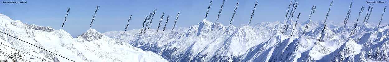
- Ruderhofspitze, 3,474 m
- Sonklarspitze, 3,463 m
- Wilder Pfaff, 3,456 m
- Wilder Freiger, 3,418 m
- Östliche Seespitze, 3,416 m
- Schrandele, 3,393 m
- Hohes Eis, 3,388 m
There is a total of just under 500 named and surveyed mountains in the Stubai Alps. Amongst the better known are (in order of height and excluding the top ten above):
- Wilde Leck, 3,361 m
- Stubaier Wildspitze, 3,341 m
- Schaufelspitze, 3,332 m
- Lüsener Fernerkogel, 3,298 m
- Breiter Grießkogel, 3,287 m
- Habicht, 3,277 m
- Östlicher Feuerstein, 3,268 m
- Schneespitze, 3,178 m
- Pflerscher Tribulaun, 3,097 m
- Hohe Villerspitze, 3,087 m
- Weißwandspitze, 3,017 m
- Sulzkogel, 3,016 m
- Hochreichkopf, 3,010 m
- Zischgeles, 3,004 m
- Roter Kogel, 2,832 m
- Gamskogel, 2,813 m
- Schlicker Seespitze, 2,804 m
- Serles, 2,717 m
- Hoher Burgstall, 2,611 m
- Lämpermahdspitze 2,595 m
- Elferspitze, 2,505 m
- Gargglerin, 2,470 m
- Saile (Nockspitze), 2,404 m
Passes
The main mountain passes of the Stubai Alps are:
| Mountain pass | location | type | elevation (m/ft) | |
|---|---|---|---|---|
| Sonklarscharte | Sölden to Sterzing | snow | 3327 | 10,916 |
| Bildstockljoch | Sölden to Ranalt | snow | 3138 | 10,296 |
| Timmelsjoch (Passo del Rombo) | Sölden to Meran | road | 2509 | 8232 |
| Jaufen Pass/Passo di Monte Giovo | Sterzing to Meran | road | 2094 | 6870 |
| Brenner Pass | Innsbruck to Verona | highway, railway | 1370 | 4495 |
External links
![]() Media related to Stubai Alps at Wikimedia Commons
Media related to Stubai Alps at Wikimedia Commons
| ||||||||
