Strona di Postua
| Strona di Postua | |
|---|---|
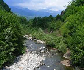 The Strona between Guardabosone and Crevacuore | |
 | |
| Origin | Monte Talamone |
| Mouth | Sessera |
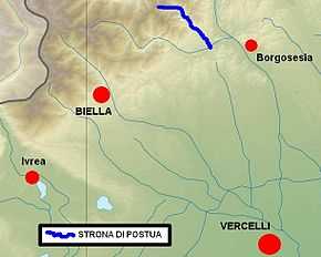
| Basin countries | Italy: province of Biella and province of Vercelli |
| Length | 14.1 km[1] |
| Source elevation | around 1800 m |
| Mouth elevation | 374[2] |
| Avg. discharge | (mouth) 1.67 m3/s[3] |
| Basin area | 37.8 [3] |
| Left tributaries | rio Brugarola |
| Right tributaries | rio Cicognana, rio Canale di Strona, rio Forcioula |
The Strona di Postua (Piemontese: Stron-a ëd Pòstua) is a 14.1 kilometres (8.8 mi) long torrent in the Piedmont region - NW Italy.
Etymology
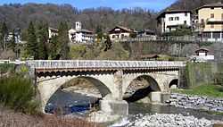
The old Postua stone bridge across the Strona.
The name Strona should come from storn or strom, celtic roots for flowing watres or river.[4] Postua is a comune located in the valley formed by the Strona.
Geography
The Strona di Postua starts in the Biellese Alps with two branches which meet at Alpe Aigra. It then flows from NW to SE reaching the village of Roncole and the inhabited part of its valley. After flanking Postua and Guardabosone it enters into the Valsessera and flows into the river Sessera near Crevacuore.[2]
See also
- Alpi Biellesi
References
- ↑ AA.VV. (2004). "Elaborato I.c/5". Piano di Tutela delle Acque - Revisione del 1º luglio 2004; Caratterizzazione bacini Idrografici. Regione Piemonte. Retrieved 2012-06-09.
- ↑ 2.0 2.1 Carta Tecnica Regionale raster 1:10.000 (vers.3.0) of Regione Piemonte - 2007
- ↑ 3.0 3.1 AA.VV. (2004). "Elaborato I.c/7". Piano di Tutela delle Acque - Revisione del 1º luglio 2004; Caratterizzazione bacini Idrografici. Regione Piemonte. Retrieved 2012-06-09.
- ↑ Comuni della Provincia di Biella, page 140; AA.VV, Nerosubianco edizioni, Cuneo 2005
Other projects
![]() Media related to Strona di Postua at Wikimedia Commons
Media related to Strona di Postua at Wikimedia Commons