Stromeferry railway station
| Stromeferry | |
|---|---|
 | |
| Location | |
| Place | Stromeferry |
| Local authority | Highland |
| Coordinates | 57°21′08″N 5°33′03″W / 57.3523°N 5.5509°WCoordinates: 57°21′08″N 5°33′03″W / 57.3523°N 5.5509°W |
| Grid reference | NG865346 |
| Operations | |
| Station code | STF |
| Managed by | ScotRail |
| Number of platforms | 1 |
|
Live arrivals/departures, station information and onward connections from National Rail Enquiries | |
| Annual rail passenger usage* | |
| 2004/05 | 1,035 |
| 2005/06 |
|
| 2006/07 |
|
| 2007/08 |
|
| 2008/09 |
|
| 2009/10 |
|
| 2010/11 |
|
| 2011/12 |
|
| 2012/13 |
|
| 2013/14 |
|
| History | |
| 19 August 1870[1] | Opened |
| National Rail – UK railway stations | |
| * Annual estimated passenger usage based on sales of tickets in stated financial year(s) which end or originate at Stromeferry from Office of Rail Regulation statistics. Methodology may vary year on year. | |
| UK Railways portal | |
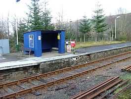
Stromeferry railway station is a station on the Kyle of Lochalsh Line, serving the village of Stromeferry in the Highlands, northern Scotland. Stromeferry lies on the southern shore of Loch Carron, across from the ruined Strome Castle, near the west coast.
For the first 27 years of its existence it was the line's terminus, bringing prosperity to the village. Steamer services linked to Portree on Skye, and Stornoway on Lewis. With the opening of the extension to Kyle of Lochalsh, steamer services were transferred there.
In the 1970s, Stromeferry became the railhead for the Kishorn Yard. Construction material was brought in by train, then transferred by ship.
| Preceding station | |
Following station | ||
|---|---|---|---|---|
| Attadale | ScotRail Kyle of Lochalsh Line |
Duncraig | ||
References
Sources
- Butt, R. V. J. (1995). The Directory of Railway Stations: details every public and private passenger station, halt, platform and stopping place, past and present (1st ed.). Sparkford: Patrick Stephens Ltd. ISBN 1-8526-0508-1. OCLC 60251199.
External links
![]() Media related to Stromeferry railway station at Wikimedia Commons
Media related to Stromeferry railway station at Wikimedia Commons