Stratford, London
| Stratford | |
 Stratford Old Town Hall |
|
 Stratford |
|
| OS grid reference | TQ385845 |
|---|---|
| – Charing Cross | 6 mi (9.7 km) WSW |
| London borough | Newham |
| Ceremonial county | Greater London |
| Region | London |
| Country | England |
| Sovereign state | United Kingdom |
| Post town | LONDON |
| Postcode district | E15, E20 |
| Dialling code | 020 |
| Police | Metropolitan |
| Fire | London |
| Ambulance | London |
| EU Parliament | London |
| UK Parliament | West Ham |
| London Assembly | City and East |
Coordinates: 51°32′32″N 0°00′09″W / 51.5423°N 0.00256°W
Stratford is a town and district in East London, England, in the London Borough of Newham. It is located 6 miles (9.7 km) east northeast of Charing Cross and is one of the major centres identified in the London Plan.[1] It was historically an agrarian settlement in the ancient parish of West Ham in the county of Essex, which transformed into an industrial suburb following the introduction of the railway in 1839. As part of the growth of London in the late 19th century, Stratford significantly expanded and increased in population, becoming the centre of administration of the Borough of West Ham in 1886 and it has formed part of Greater London since 1965. The more recent economic history is underpinned by a move away from railway works and heavy industry towards becoming a significant commercial and cultural centre. Stratford is the location of the London Olympic Park and is currently experiencing regeneration and expansion linked to the 2012 Summer Olympics.
History
Toponymy
The name is first recorded in 1067 as Strætforda and means 'ford on a Roman road'.[2] It is formed from Old English 'stræt' and 'ford'. The crossing is that of the London to Colchester road over one of the many branches of the River Lea to the west of the settlement.[2] The nearby settlement of Bow — over the River Lea and now in Tower Hamlets — was also known as Stratford and a variety of suffixes were used to distinguish the two.[2] The settlement to the east of the Lea was also known as Estratford referring to the location east of the other Stratford, Statford Hamme alluding to the location within the parish of West Ham, Abbei Stratford, referring to the presence of Stratford Langthorne Abbey[2] and Stretford Langthorne.
Economic development
Stratford was originally an agricultural community, whose proximity to London provided a ready market for its produce. By the 18th century, the area around Stratford was noted for potato growing, a business that continued into the mid-1800s.[3] Stratford also became a desirable country retreat for wealthy merchants and financiers, within an easy ride of the City. When Daniel Defoe visited Stratford in 1722, he reported that it had "...increased in buildings to a strange degree, within the compass of about 20 or 30 years past at the most". He continues that "...this increase is, generally speaking, of hansom large houses... being chiefly for the habitations of the richest citizens, such as either are able to keep two houses, one in the country, and one in the city; or for such citizens as being rich, and having left off trade, live altogether in these neighbouring villages, for the pleasure and health of the latter part of their days".[4]
An early industrial undertaking at Stratford was the Bow porcelain factory, which despite the name, was on the Essex side of the River Lea. Using a process that was patented in 1744, Edward Heylin and Thomas Frye operated a factory near Bow Bridge called "New Canton" to produce some of the first soft-paste porcelain to be made in the country.[5] The site of the factory was to the north of Stratford High Street near the modern Bow Flyover; it was the subject of archaeological excavations in 1921 and 1969.[6]
By the early 19th century, Stratford was an important transport hub, with omnibuses and coaches running into London four times every hour and coaches from East Anglia passing through hourly. The route into London was plied by Walter Hancock's steam coaches for a period during the 1830s.[7]
A small dock and a number of wharves were operating on the River Lea at Stratford by the 1820s, serving the needs of local industries. However, the opening of the nearby Royal Victoria Dock in 1855 and the subsequent construction of the Royal Group of Docks (at one time the largest area of impounded water in the world), increased Stratford's importance as a transport and manufacturing centre.[8]

In 1839, the Great Eastern Railway built a railway station at Stratford, which was the point at which their two main routes diverged; one going from London to Cambridge and the other to Colchester. A railway works and depot for engines and rolling stock was established by Great Eastern in 1847 to the north of Stratford. At its peak, the works employed over 2,500 many of whom had homes, along with other rail workers, in the town that developed nearby. It was originally called Hudson Town, after George Hudson, the "Railway King;", but after his involvement in bribery and fraud was revealed in 1849, the settlement quickly became better known as Stratford New Town, which by 1862 had a population of 20,000.[9] During the lifetime of the Stratford works, 1,682 locomotives, 5,500 passenger coaches and 33,000 goods wagons were built. The last part of the works closed in March 1991.[10]
Local government

Stratford was one of three ancient wards in the large parish of West Ham, in the Becontree hundred of Essex. It came within the Metropolitan Police District in 1840.[11] Despite forming part of the built up area of London the parish remained outside the statutory metropolitan area established in 1855 and the County of London established in 1889. Instead, administrative reform was undertaken in the area in much the same way as a large provincial town. A local board was formed in 1856 under the Public Health Act 1848 and subsequently the parish was incorporated as a municipal borough in 1886. In 1889 the borough was large enough in terms of population to become a county borough and was outside the area of responsibility of Essex County Council. Stratford formed the centre of administration of the county borough and was the location of the town hall.
Geography
Stratford borders to the west with Hackney Wick in the London Borough of Hackney and the London Borough of Tower Hamlets and Bow in the London Borough of Tower Hamlets, and to the north with Leyton in London Borough of Waltham Forest. Within Newham, Forest Gate is the east, West Ham to the southeast and Plaistow to the south. The River Lea and the complex network of Bow Back Rivers mark the western limits of the area. The Royal Mail has given the postcode E20 to the Olympic Park and Stratford City developments; this was only used by the BBC TV soap EastEnders for the fictional suburb of Walford.[12]
To the west, immediately adjacent to the site of a Tesco store at Bromley-by-Bow, is the 26 acres (11 ha) "Strand East" development area, where construction of new housing and other premises is being led by Ikea.[13]
Nearest places:
- Bow
- West Ham
- Victoria Park
- River Lea
- Old Ford
- Leyton
- Leytonstone
- Hackney Wick
Economy

Both of Stratford's shopping centres: The Stratford Centre and the recently opened (2011) Westfield Stratford City are located on either side of Stratford station. Westfield Stratford City, home to 350 stores, is one of the largest shopping centres in Europe. The older centre has a range of accessibly-priced stores, its indoor and outdoor market stalls, and the 'inshops' network of small retail outlets. The centre occupies much of the 'island site' created in the 1960s by the surrounding gyratory traffic system.


Redevelopment
Stratford has been a focus of regeneration for some years, and is the location of a number of major projects.
Complete developments:
- Westfield Stratford City is a multi-billion pound scheme to regenerate the 73-hectare brownfield railway lands to the north of the existing town centre. The vast shopping centre reported to be bigger in size than Bluewater was opened in September 2011. It has anchor stores for John Lewis, Waitrose and Marks and Spencer, in addition to other household names like Apple and Primark. The centre boasts a range of restaurant outlets, a cinema and casino, making it a leisure destination in itself, as well as its shopping facilities. Nearby will be a new purpose-built community of 5,000 homes, offices, schools, public spaces, municipal and other facilities destined to become a major metropolitan centre for East London, all to coincide with the opening of the Olympics in July 2012.
- The 2012 Olympic and Paralympic Games had their main base at the Olympic Park, which contained a significant number of venues including the Olympic Stadium, Aquatics Centre, and London Velopark. What was the athletes' Olympic Village is to be restructured as the new East Village development, providing 3,500 homes, half affordable and half private. The post- Olympics legacy plans include the largest new urban park in Europe for over a century, and the new Chobham Academy.
- Improving Stratford station with new platforms, walkways and entrances.
- 150 High Street, Stratford, a 41-storey 133 m (436 ft) high residential tower.
Current Olympic Park developments:
- Construction of East Wick & Sweetwater neighbourhoods will see up to 1,500 homes built[14]
- Olympicopolis; A plan in the Olympic Park to see the Victoria & Albert Museum and University College London to have facilities by 2018.[15]
- International Quarter; will see 13 Office and 2 residential buildings as well as a hotel.[16]
- iCity; a technology development will Loughborough University will establish a tech campus. Other companies are yet to be announced.
Other current developments:
- Stratford Centre is proposing to re-develop its site, with a 26 story residential building for students and to have additional parking and shops in the shopping centre.[17]
- Stratford Plaza building
- Broadway Chambers development with 39 story and 20 story buildings with 388 apartments[18]
- Olympian Tower; a 26 Story building.[19]
- Strand East; will see 1,200 homes as well as space for technology businesses and amenities[20][21]
- Rebuilding of Pudding Mill Lane DLR station as part of the Crossrail project[22]
Transport

Stratford is a significant transport hub, well served by bus routes, and with five railway stations.
- Stratford Regional
Stratford Regional is located on the National Rail Great Eastern Main Line, North London Line as well as the Lea Valley Lines. National Rail services: Abellio Greater Anglia and London Overground regularly serve the station to and from London Liverpool Street, Romford, the East of England, Stansted and Southend airports, and other parts of north London. London Underground's Central and Jubilee lines both serve the regional station and link Stratford to Oxford Street, Wembley Stadium, Epping and Canary Wharf. The Jubilee line was extended to Stratford in 1999.
The Docklands Light Railway (DLR) was extended to Stratford in 1987, and to Stratford International in 2011, with services to Poplar, Canary Wharf, Lewisham, London City Airport, the Excel Centre, Beckton and Woolwich Arsenal. A bus station is located adjacent to Stratford Regional with London Buses and National Express coach routes towards central, northeast London and Stansted Airport.[23]
- Stratford International and Stratford High Street
Stratford International, located to the northwest, is on the HS1 line from St Pancras International to Kent, and is served by Southeastern domestic high speed services; so far, no decision has been made for international Eurostar services to call. The International and Regional stations are linked by a branch of the Docklands Light Railway – opened in August 2011 – which also serves a new DLR only station at Stratford High Street to the south of Stratford, situated on the site of the former Stratford Market railway station.
- Maryland
The eastern part of Stratford is served by Maryland railway station. The Liverpool Street to Shenfield via Ilford and Romford service known as the Shenfield Metro service and runs every 10 minutes. This service also calls at Stratford and is planned to be incorporated into the Crossrail service by 2017.
- Pudding Mill Lane
Pudding Mill Lane is in the south of the Olympic Park (though it closed during the Olympics for safety reasons due to its size), and normally provides transport to the local factories. Served by the Docklands Light Railway to Stratford, Poplar and Canary Wharf, it is planned to be re-sited south as part of the Crossrail project.
Landmarks

Church of St John the Evangelist
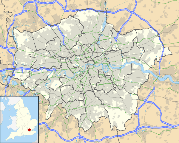
Stratford Broadway, the main thoroughfare, is dominated by the Anglican parish church. It was built between 1832 and 1834 by Edward Blore in the Early English style using grey brick. The most notable feature is a three-stage tower, surmounted by a spire which is supported with flying buttresses. It is a Grade II Listed building.[24] It was built as a chapel of ease to save worshippers the journey to the ancient parish church of All Saint's West Ham; St John's Stratford became a separate ecclesiastical parish in 1844.[25] The poet Gerard Manley Hopkins was baptised in the church as an infant in August 1844. The naturalist and social reformer Antonio Brady is buried in the churchyard; an extension to the chancel of the church was constructed in his memory in 1884.[26] In World War II, the church crypt served as an air raid shelter for local people, despite bomb damage to the building itself. A new extension was added in 1998.[27] The site was previously home to a "Forest Prison" that incarcarated those who committed offences against the Royal Forest of Waltham, which is now known as Epping Forest. The gaol was built around 1620 and the building remained until 1827.[28]
Martyr's Memorial
Within the churchyard of St John's is a memorial to the Stratford Martyrs, who were burned at the stake in 1556 during the reign of Queen Mary. The memorial itself is octagonal with terracotta plaques on each face, surmounted by a twelve sided spire. It was unveiled in 1878.[29]
Gurney Memorial Drinking Fountain
Directly to the south of the churchyard stands a 12.80 metre tall granite obelisk, which was erected in 1861 as a memorial to the Quaker philanthropist and abolitionist, Samuel Gurney (1766 to 1856). The plinth carries two brass drinking fountain heads on opposite sides, and the inscription; IN REMEMBRANCE OF SAMUEL GURNEY / WHO DIED THE 5TH OF JUNE 1856 / ERECTED BY HIS FELLOW PARISHIONERS AND FRIENDS / 1861 / "When the ear heard him then it blessed him"[30] (a paraphrase from the Book of Job, Chapter 29 verse 11).
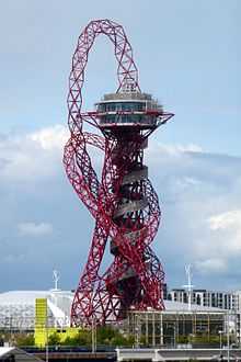
Old Town Hall
Designed by Lewis Angell and John Giles in the Italianate style with a 100-foot (30.5 metre) tall domed tower, it opened in 1869 as the public offices for the West Ham Local Board of Health. It later became the town hall for the county borough and was enlarged in 1881 to accommodate a courthouse and cells.[31] On 26 June 1982, the main part of the building was badly damaged by fire; after a painstaking reconstruction of the original features and refurbishment as a conference centre, it was reopened by the Queen in July 1986. It is a Grade II Listed Building.[32]
King Edward VII public house
Opposite St John's Church stands an early 19th-century pub, the King Edward VII with original pedimented doors and early 19th-century bay windows. It was originally called "The King of Prussia", either in honour of Frederick the Great or else after King Frederick William IV who visited the area in 1842 to meet Elizabeth Fry, the prison reformer. However, the name was changed at the start of World War I in 1914 for patriotic reasons.[33] It is a Grade II Listed Building.[34]
"Robert" the tank engine
A 38 tonne 0-6-0 saddle-tank steam locomotive named "Robert" is displayed in Meridian Square, the forecourt of Stratford Station. It was built in 1933 by the Avonside Engine Company of Bristol for use at the Lamport Ironstone mines railway near Brixworth, Northamptonshire. It was previously an exhibit at the North Woolwich Old Station Museum, but moved to Stratford in 1999. In 2008, it was removed to the East Anglia Railway Museum at Chappel and Wakes Colne railway station near Colchester; there it was cleaned and repainted at the expense of the Olympic Delivery Authority and returned to Stratford in 2011.[35]
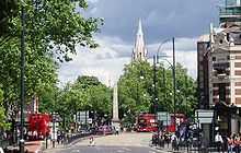
ArcelorMittal Orbit
A 114-metre-tall (374 ft) sculpture and observation tower in the Queen Elizabeth Olympic Park. It is Britain's largest piece of public art, and is intended to be a permanent legacy of the 2012 Summer Olympics. It closed after the end of the Games, but was re-opened to the public in April 2014.[36]

Abbey Mills Pumping Station
Built in 1868 as part of the new London sewerage system by Sir Joseph Bazalgette, the building originally housed steam pumps and is a notable example of Italian style Gothic Revival architecture. It is opened to the public on an occasional basis, when the "flamboyant interior of enriched cast ironwork" can be seen. It was used to portray a lunatic asylum in the 2005 film Batman Begins, and is a Grade II* listed building.[37]
Culture

Stratford's Cultural Quarter, adjacent to the shopping centre, is home to several arts venues, bars and cafes:
- Theatre Royal Stratford East – NB: 'Stratford East' is not a location; the 'East' is used to differentiate between Stratford (east London) and Stratford-upon-Avon
- Stratford Circus
- The Discover Children's Story Centre is a partner in the Cultural Quarter
Stratford has been the location for numerous films, notably Sparrows Can't Sing (1963) and Bronco Bullfrog (1970). The promotional film for the Beatles' "Penny Lane" single was filmed in and around the southern part of Angel Lane, demolished in the late 1960s to build the Stratford Centre.
Education
The University of East London (UEL) has a major campus in Stratford, whose main building, University House, is a historic listed building dating from the 19th Century. The adjacent Passmore Edwards Building is also one of the area's most historic and beautiful buildings, with colourful frescoes and domed roof. In addition, Birkbeck College, part of the University of London, has launched courses in the area, initially using space provided by UEL, with a view to constructing its own campus in Stratford. A new university is planned on the Olympic Park following the 2012 Olympic Games.
People from Stratford
- See Category:People from Stratford, London
See also
- Stratford City
- Stratford Martyrs
- Maryland, London
- List of people from Newham
- List of schools in Newham
References
- ↑ Mayor of London (February 2008). "London Plan (Consolidated with Alterations since 2004)" (PDF). Greater London Authority.
- ↑ 2.0 2.1 2.2 2.3 Mills, D. (2000). Oxford Dictionary of London Place Names. Oxford.
- ↑ W R Powell (editor), A History of the County of Essex: Volume 5, Victoria County History 1966, Metropolitan Essex since 1850: Population growth and the built-up area (pp. 2-9)
- ↑ Defoe, Daniel (1722), A tour thro' the whole island of Great Britain, divided into circuits or journies (Volume I, Letter I)
- ↑ Victoria County History - A History of the County of Middlesex: Volume 2 (1911), Industries: Pottery - Bow Porcelain (pp. 146-150)
- ↑ The Newham Story - Image Gallery - Stratford E15 - Bow Porcelain - 34
- ↑ Victoria County History, A History of the County of Essex: Volume 6 (1973): West Ham - Transport and Postal Services (pp.61-63)
- ↑ Victoria County History, A History of the County of Essex: Volume 6 (1973): West Ham - Wharfs and Docks (p.61)
- ↑ Edward Walford, Old and New London: Volume 5, 1878 (pp. 570-576)
- ↑ The Newham Story - Image Gallery - Stratford E15 - Stratford Railway Works - General Offices Building
- ↑ West Ham - Local government and public services | A History of the County of Essex: Volume 6 (pp. 96-112). British-history.ac.uk. Retrieved on 2013-07-17.
- ↑ BBC News: London - Olympic Park to share EastEnders' Walford E20 postcode Accessed 19 March 2011
- ↑ Beanland, Chris (4 October 2012). "London's newest development: The rise of the Ikea city". The Independent. Retrieved 5 October 2012.
- ↑ London Legacy Development Corp. East Wick & Sweetwater Accessed 31 December 2013
- ↑ London Evening Standard: 'Olympicopolis': Multi-million pound cultural hub planned for Olympic Park Accessed 31 December 2013
- ↑ The International Quarter: Plots and Areas Accessed 31 December 2013
- ↑ Stratford Centre: Development Accessed 31 December 2013
- ↑ Stratford Renaissance: Broadway Chambers Accessed 31 December 2013
- ↑ Stratford Renaissance: Olympian Tower Accessed 31 December 2013
- ↑ Strand East: About 31 December 2013
- ↑ LLDC: Developments around the park 31 December 2013
- ↑ Crossrail: REPLACEMENT DLR STATION AT PUDDING MILL LANE APPROVED AND WILL ENABLE CROSSRAIL TUNNELS TO PROCEED Accessed 31 December 2013
- ↑ http://www.tfl.gov.uk/tfl/gettingaround/maps/buses/pdf/stratford-2242.pdf
- ↑ British Listed Buildings: Church of St John the Evangelist, Stratford
- ↑ Victoria County History, A History of the County of Essex: Volume 6 (1973): West Ham - Churches (pp.114-123)
- ↑ St John's Church, Stratford E15: A Brief History Of The Parish - The 19th Century
- ↑ St John's Church, Stratford E15: A Brief History Of The Parish - The 20th Century
- ↑ http://www.british-history.ac.uk/report.aspx?compid=42757
- ↑ British Listed Buildings: Martyrs' Memorial, Stratford
- ↑ Visual Arts Data Service - Public Monuments & Sculpture Association: Samuel Gurney Memorial
- ↑ "1869 – Public Office & Vestry Hall, Stratford, London". archiseek.com. Retrieved 25 October 2014.
- ↑ "The Old Town Hall Stratford". http://www.stratfordlondon.info/''. Stratford Renaissance Partnership. Retrieved 25 October 2014.
- ↑ EXPLORING EAST LONDON - STRATFORD, WEST HAM: King Edward VII
- ↑ British Listed Buildings: King Edward Vii Public House 47, Stratford
- ↑ 2012 Media centre - Press release, 5 April 2011: "Landmark steam locomotive Robert the Engine back home"
- ↑ "ArcelorMittal Orbit". queenelizabetholympicpark.co.uk. London Legacy Development Corporation. Retrieved 6 March 2014.
- ↑ British Listed Buildings - Abbey Mills Pumping Station, Newham
External links
| Wikimedia Commons has media related to Stratford, London. |
- Description of Stratford in 1876
- Archaeology at the Olympic site
- History of Stratford site with links to historic Post Office directories
- A Brief History Of The Parish Of Stratford
- Local guide to and blog about contemporary Stratford
| ||||||||||||||||||||||||||||||||||||
