Strandfontein, West Coast District
Not to be confused with Strandfontein, Cape Town.
| Strandfontein | |
|---|---|
|
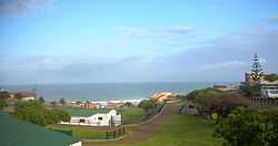
Strandfontein camp site | |
 Strandfontein
| |
| Coordinates: 31°45′20″S 18°13′38″E / 31.75556°S 18.22722°ECoordinates: 31°45′20″S 18°13′38″E / 31.75556°S 18.22722°E | |
| Country | South Africa |
| Province | Western Cape |
| District | West Coast |
| Municipality | Matzikama |
| Area[1] | |
| • Total | 4.18 km2 (1.61 sq mi) |
| Population (2011)[1] | |
| • Total | 431 |
| • Density | 100/km2 (270/sq mi) |
| Racial makeup (2011)[1] | |
| • Black African | 50.6% |
| • Coloured | 14.8% |
| • Indian/Asian | 0.9% |
| • White | 33.2% |
| • Other | 0.5% |
| First languages (2011)[1] | |
| • Afrikaans | 69.4% |
| • Xhosa | 22.6% |
| • English | 3.2% |
| • Sotho | 2.7% |
| • Other | 2.2% |
| Postal code (street) | 7798 |
| PO box | 7788 |
Strandfontein is a settlement in West Coast District Municipality in the Western Cape province of South Africa.
Seaside resort in the former Vredendal district, south of the Olifants River Mouth. The name is Afrikaans for ‘beach spring’.[2]
Located a few km north up the coast by the mouth of the Olifants River.[3]
References
- ↑ 1.0 1.1 1.2 1.3 "Main Place Strandfontein". Census 2011.
- ↑ "Dictionary of Southern African Place Names (Public Domain)". Human Science Research Council. p. 419.
- ↑ Cornel Truter, West Coast tourist guide, University of Cape Town Press, ISBN 9781919713243
| |||||||||||||||||||||||||||||
.svg.png)