Strömsholm Canal
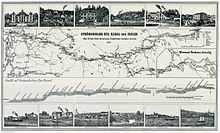
Map from 1867.
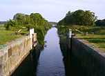
The Strömsholm Canal (Swedish: Strömsholms kanal) runs from Smedjebacken to Lake Mälaren near Strömsholm. It is 62 miles long with 26 locks. It consists of a string of lakes connected by short manmade cuts.
The canal took 18 years to build, between 1772 and 1795, to plans laid out by Johan Ullström. The main reason for it was the transport of iron produced by the many steelworks sited along the length of the waterway. The opening of the Stockholm Wästerås-Bergslagen railway marked the beginning of its decline and today the restored canal is only used by pleasure craft.
Gallery
-
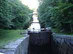
Lock Konung Gustav III
-
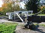
Lock Landshövding af Ugglas
-
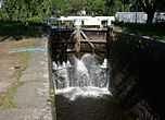
Lock Kronprinsessan Victoria
-
Lock Konung Karl XV
Bibliography
- McKnight, Hugh, The Guinness Guide to Waterways of Western Europe, Guinness (1978)
External links
| Wikimedia Commons has media related to Strömsholm Canal. |
- Strömsholm canal - Official site