Storseisundet Bridge
| Storseisundet Bridge Storseisundbrua | |
|---|---|
|
View of the bridge | |
| Coordinates | 63°01′00″N 7°21′11″E / 63.0166°N 7.3530°ECoordinates: 63°01′00″N 7°21′11″E / 63.0166°N 7.3530°E |
| Carries | 64 |
| Crosses | Storseisund |
| Locale | Eide & Averøy, Norway |
| Characteristics | |
| Design | Cantilever bridge |
| Total length | 260 metres (850 ft) |
| Longest span | 130 metres (430 ft) |
| Clearance below | 23 metres (75 ft) |
| History | |
| Opened | 7 July 1989 |
| Statistics | |
| Toll | until 1999 |
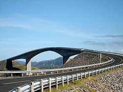
The Storseisundet Bridge (Norwegian: Storseisundetbrua) is the longest of the eight bridges that make up the Atlanterhavsveien ("The Atlantic Road"), the road connection from the mainland Romsdal peninsula to the island of Averøya in Møre og Romsdal county, Norway. This bridge sits on the border between Eide Municipality and Averøy Municipality.
Storseisundet Bridge is a cantilever bridge that is 260 metres (850 ft) long and with a maximum clearance to the sea of 23 metres (75 ft). It was opened on 7 July 1989, and it was a toll road until June 1999.[1][2]
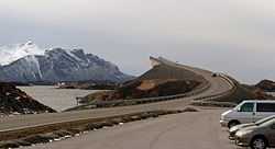
Storseisundet Bridge, "The road to nowhere"[3]
The bridge was described as "The road to nowhere" by the Daily Mail in 2011.[3][4]
See also
References
- ↑ "Road Viaducts & Bridges in Norway (499–200 m)". Retrieved 2010-11-18.
- ↑ "Technical information". Atlanterhavsveien AS. Retrieved 2010-11-18.
- ↑ 3.0 3.1 White, James (3 November 2011). "The road to nowhere! Norwegian bridge gives motorists a fright (but don't worry, it's just an optical illusion)". Daily Mail. Retrieved 19 January 2015.
- ↑ Denne norske brua fenger britiske lesere in Nettavisen, 3 November 2011
External links
| Wikimedia Commons has media related to Storseisundet bru. |
- Atlanterhavsveien – official website
- Photo of the bridge in a storm