Stoney Indian Peaks
| Stoney Indian Peaks | |
|---|---|
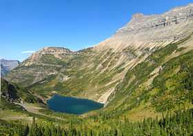 Stoney Indian Peaks at right above Stoney Indian Lake | |
| Elevation | 9,350 ft (2,850 m)[1] |
| Prominence | 830 ft (250 m)[1] |
| Location | |
| Location | Glacier County, Montana, U.S. |
| Range | Lewis Range |
| Coordinates | 48°53′55″N 113°51′30″W / 48.89861°N 113.85833°WCoordinates: 48°53′55″N 113°51′30″W / 48.89861°N 113.85833°W[2] |
| Topo map | USGS Mount Cleveland, MT |
Stoney Indian Peaks (9,350 feet (2,850 m)) is located in the Lewis Range, Glacier National Park in the U.S. state of Montana.[1][2] Consisting of several summits, the mountain is in the northeastern region of Glacier National Park, less than 2 miles (3.2 km) south of Mount Cleveland.[1] Stoney Indian Lake is south of the peaks.
See also
- Mountains and mountain ranges of Glacier National Park (U.S.)
References
- ↑ 1.0 1.1 1.2 1.3 "Stoney Indian Peaks, Montana". Peakbagger.com. Retrieved 2010-07-11.
- ↑ 2.0 2.1 "Stoney Indian Peaks". Geographic Names Information System. United States Geological Survey. Retrieved 2010-07-11.