Steinfeld, South Australia
| Steinfeld South Australia | |||||||||||||
|---|---|---|---|---|---|---|---|---|---|---|---|---|---|
|
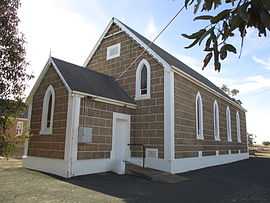
St Stephen's Lutheran Church, Stonefield | |||||||||||||
 Steinfeld | |||||||||||||
| Coordinates | 34°20′50″S 139°18′07″E / 34.34728°S 139.301960°ECoordinates: 34°20′50″S 139°18′07″E / 34.34728°S 139.301960°E | ||||||||||||
| Postcode(s) | 5356 | ||||||||||||
| LGA(s) | Mid Murray Council and Regional Council of Goyder | ||||||||||||
| State electorate(s) | Stuart | ||||||||||||
| Federal Division(s) | Barker | ||||||||||||
| |||||||||||||
Steinfeld (formerly Stonefield) is a locality in South Australia east of the Mount Lofty Ranges. The village of Steinfeld was established in the 19th century. It was renamed to Stonefield in 1918 as many places with German or German-sounding names were changed around World War 1. The name reverted to Steinfeld in 1986.[1]
The main part of the bounded locality now known as Steinfeld, including the original village, is in the Mid Murray Council. The northwestern corner of the locality is in the Regional Council of Goyder. That corner is also in the federal Division of Grey, rather than the Division of Barker like the rest of the locality.
The Barossa Valley Gliding Club and Adelaide University Gliding club share an airfield at Steinfeld.
References
| Wikimedia Commons has media related to Steinfeld, South Australia. |
- ↑ "Placename Details: Steinfeld". Property Location Browser. 9 August 2006. SA0063130. Retrieved 3 March 2015.
| ||||||
| ||||||