Stehekin, Washington
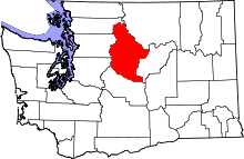
Coordinates: 48°18′34″N 120°39′19″W / 48.30944°N 120.65528°W Stehekin /stəˈhiːkən/[1] is a small unincorporated community in Chelan County, Washington. It is part of Wenatchee–East Wenatchee Metropolitan Statistical Area. Located at the northwest end of Lake Chelan, it lies just south of the North Cascades National Park. It is within Lake Chelan National Recreation Area, a unit administered by the National Park Service. Stehekin has about 75 permanent residents,[2] though its population swells during the summer with vacationers and seasonal workers. The name "Stehekin" comes from a Native American word meaning "the way through."[2]
Sights in Stehekin include the Buckner Homestead Historic District, The Golden West Visitor Center, Stehekin Pastry Company, the one-room Stehekin School, the 312' Rainbow Falls, and Harlequin Bridge. Stehekin is visited by hikers and bikers in the summer, and snowshoers and skiers in the winter, as well as photographers year-round.
There is no road access to Stehekin, though roughly 22 miles of road exist there. It is reachable by passenger ferry (the Lady of the Lake), by foot over the Cascade Pass, by private boat from Chelan, or by floatplane. The vehicles in Stehekin have been barged there on Lake Chelan.
In addition to access by Lake Chelan, visitors come to Stehekin by horseback, hiking, and flying into Stehekin State Airport (Identifier 6S9). The airport is only open July, August, and September, and is noted by Washington State as being one of the state's most challenging airports. While only 1,230 ft (370 m) msl, there are mountains on the sides and trees at each end of the 2,630 ft (800 m) runway. The airport is often a base for firefighting, at which times it is closed to public use. The Harlequin campground is located next to the airport. Trout and sockeye salmon are popular targets for fishing in Stehekin.
In 2003, much of the upper (northern) half of the Stehekin Valley Road was washed out by the nearby Stehekin River. Thus, access via Cascade Pass has become more difficult, adding as much as 10 miles (16 km) to the already strenuous trek.
Another town with a similarly small population and similar access is Holden Village, surrounded by the Glacier Peak Wilderness and located 12 miles (19 km) up the Railroad Creek Valley from Lucerne, a boat landing on Lake Chelan.
Climate
| Climate data for Stehekin, Washington (1985 - 2014 normals) | |||||||||||||
|---|---|---|---|---|---|---|---|---|---|---|---|---|---|
| Month | Jan | Feb | Mar | Apr | May | Jun | Jul | Aug | Sep | Oct | Nov | Dec | Year |
| Record high °F (°C) | 55 (13) |
59 (15) |
70 (21) |
88 (31) |
101 (38) |
103 (39) |
107 (42) |
105 (41) |
98 (37) |
84 (29) |
67 (19) |
62 (17) |
107 (42) |
| Average high °F (°C) | 33.5 (0.8) |
38.7 (3.7) |
47.7 (8.7) |
58.8 (14.9) |
68.7 (20.4) |
75.7 (24.3) |
85.3 (29.6) |
84.2 (29) |
74.1 (23.4) |
57.5 (14.2) |
41.2 (5.1) |
33.1 (0.6) |
58.21 (14.56) |
| Average low °F (°C) | 18.6 (−7.4) |
21.7 (−5.7) |
30.4 (−0.9) |
38.0 (3.3) |
44.1 (6.7) |
51.2 (10.7) |
58.7 (14.8) |
58.1 (14.5) |
50.5 (10.3) |
36.4 (2.4) |
26.8 (−2.9) |
19.3 (−7.1) |
37.82 (3.22) |
| Record low °F (°C) | −18 (−28) |
−16 (−27) |
−5 (−21) |
19 (−7) |
25 (−4) |
30 (−1) |
36 (2) |
30 (−1) |
22 (−6) |
16 (−9) |
0 (−18) |
−11 (−24) |
−18 (−28) |
| Average precipitation inches (mm) | 6.43 (163.3) |
3.67 (93.2) |
2.98 (75.7) |
1.63 (41.4) |
1.13 (28.7) |
0.79 (20.1) |
0.55 (14) |
0.63 (16) |
0.98 (24.9) |
3.46 (87.9) |
6.80 (172.7) |
6.45 (163.8) |
35.5 (901.7) |
| Average snowfall inches (cm) | 41.3 (104.9) |
19.7 (50) |
8.4 (21.3) |
0.2 (0.5) |
0 (0) |
0 (0) |
0 (0) |
0 (0) |
0 (0) |
0.0 (0) |
10.9 (27.7) |
42.0 (106.7) |
122.5 (311.1) |
| Source: NOAA[3] | |||||||||||||
Telephone Service
Between March 15 and 28 of 2007, WeavTel, a telecommunications company based in Chelan (at the head of the lake) began normal operations of standard-delivery residential and business telephone service. Stehekin, previously served only by highly expensive satellite and radio telephones, finally joined the Washington Telephone Grid after decades of isolation. The move was not widely accepted amongst residents; however, business owners agreed that there is a benefit to having normal telephone service.[4] The service is currently limited to the Lower Stehekin Valley, around Stehekin Landing and the village proper, but WeavTel is applying for permits to extend the service into the Upper Valley using underground fiber-optic cables. The move was made possible under Federal and State grants that provide support for any telecommunications company willing to extend service to rural areas. Although most other areas of North Central Washington have standard service, most of the areas outside of Wenatchee benefit from the grants as well. One of the first calls, a test call, was placed from Stehekin's Silver Bay Resort.[5]
References
- ↑ "A Northwest Pronunciation Guide". Retrieved 18 April 2013.
- ↑ 2.0 2.1 Gulick, Bill (1996). A Traveler's History of Washington. Caldwell, Idaho: Caxton Press. p. 345. ISBN 0-87004-371-4.
- ↑ "NowData – NOAA Online Weather Data". National Oceanic and Atmospheric Administration. Retrieved January 17, 2015.
- ↑ "Park Service: Phones will do little to change Stehekin's 'social fabric'". The Wenatchee World. Retrieved 2006-06-17.
- ↑ "A first for Stehekin ... a dial tone". The Wenatchee World. Retrieved 2007-04-06.
External links
| |||||||||||||||||||||||||||||
