Statts Mills, West Virginia
| Statts Mills, West Virginia | |
|---|---|
| Unincorporated community | |
 Statts Mills, West Virginia | |
| Coordinates: 38°44′15″N 81°37′20″W / 38.73750°N 81.62222°WCoordinates: 38°44′15″N 81°37′20″W / 38.73750°N 81.62222°W | |
| Country | United States |
| State | West Virginia |
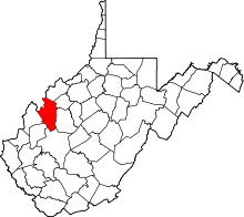
| County | Jackson |
| Elevation | 646 ft (197 m) |
| Time zone | Eastern (EST) (UTC-5) |
| • Summer (DST) | EDT (UTC-4) |
| Area code(s) | 304 & 681 |
| GNIS feature ID | 1549939[1] |
Statts Mills is an unincorporated community in Jackson County, West Virginia, United States. Statts Mills is located on the Tug Fork and County Route 36 7.5 miles (12.1 km) southeast of Ripley.[2] Statts Mills had a post office, which closed on July 30, 2005.[3]
References
- ↑ U.S. Geological Survey Geographic Names Information System: Statts Mills, West Virginia
- ↑ Jackson County, West Virginia General Highway Map (Map). West Virginia Department of Transportation. 2011. p. 3. Retrieved October 12, 2011.
- ↑ "Postmaster Finder - Post Offices by ZIP Code". United States Postal Service. Retrieved October 12, 2011.
| |||||||||||||||||||||||||