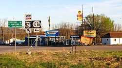
Static, Kentucky and Tennessee
| Static | |
|---|---|
| Unincorporated community | |
 | |
 Static Location within the state of Kentucky | |
| Coordinates: 36°37′19″N 85°5′6″W / 36.62194°N 85.08500°WCoordinates: 36°37′19″N 85°5′6″W / 36.62194°N 85.08500°W | |
| Country | United States |
| State | Kentucky, Tennessee |
| Counties | Clinton, KY and Pickett, TN |
| Elevation | 1,004 ft (306 m) |
| Time zone | Central (CST) (UTC-6) |
| GNIS feature ID | 504285[1] |
| GNIS feature ID | 1271280[2] |
Static is an unincorporated community in Clinton County, Kentucky, and Pickett County, Tennessee, in the southeastern United States. It is located on the Tennessee–Kentucky state-line south of Albany, Kentucky, northwest of Jamestown, Tennessee and north of Byrdstown, Tennessee.
Static has been noted for its unusual place name.[3][4]
Geography
Static is located at a crossroads intersection involving U.S. Route 127 (US 127), Tennessee State Route 111 (TN 111) (formerly Tennessee State Route 42), and Kentucky Route 1076. Its coordinates are 36°37′19″N latitude, and 85°5′6″W longitude. Using US 127, Jamestown, Tennessee, is 21 miles (33.8 km) southeast, and Albany, Kentucky, is six miles north. Byrdstown, Tennessee, however, is 6 miles (9.65 km) southwest via TN 111.
The town is located due east of the Dale Hollow Lake area.
Education
In terms of public schools, the Kentucky side of the Static area attends Clinton County Schools based in Albany, while students on the Tennessee side attend the small Pickett County Public Schools system.
Sites of interest
There is a reason why Static is a rather unusual place due to its location on the state line. The convenience store on the Kentucky side of the state line is a typical gas station offering snacks and lottery tickets. Businesses on the Tennessee side, however, have beer and fireworks available, although fireworks are only sold during the summer.
Halfway between Static and Jamestown, Tennessee on US 127 sits the Sgt. Alvin C. York Historic State Park in Pall Mall.
References
- ↑ U.S. Geological Survey Geographic Names Information System: Static, Kentucky and Tennessee
- ↑ U.S. Geological Survey Geographic Names Information System: Static, Kentucky and Tennessee
- ↑ Petras, Kathryn; Petras, Ross (18 December 2007). Unusually Stupid Americans: A Compendium of All-American Stupidity. Random House Publishing Group. p. 246. ISBN 978-0-307-41761-9.
- ↑ Static Ky. H.B. Elkins' MillenniumHwy.net. Retrieved October 15, 2014.
| |||||||||||||||||||||
| |||||||||||||||||||||
