States and union territories of India
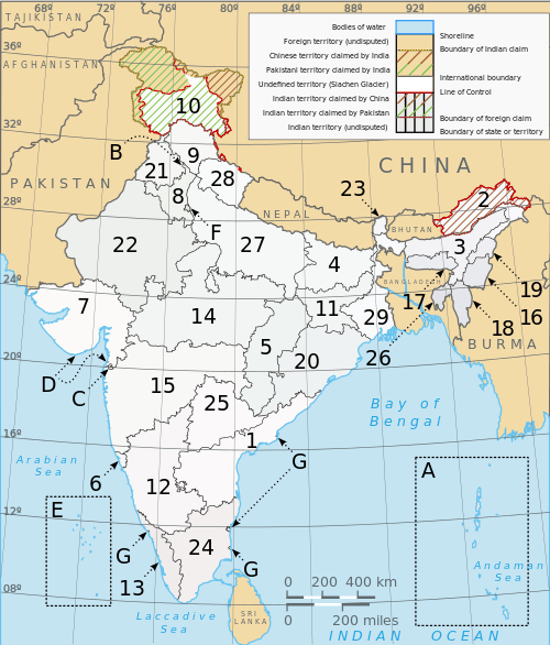
India is a federal union of states comprising twenty-nine states and seven union territories. The states and union territories are further subdivided into districts and further into smaller administrative divisions.
Responsibilities and authorities
The Constitution of India distributes the sovereign powers exercisable with respect to the territory of any State between the Union and that State. "Article 73 broadly stated, provides that the executive power of the Union shall extend to the matters with respect to which Parliament has power to make laws. Article 162 similarly provides that the executive power of a State shall extend to the matters with respect to which the Legislature of a State has power to make laws. The Supreme Court has reiterated this position when it ruled in the Ramanaiah case that the executive power of the Union or of the State broadly speaking, is coextensive and coterminous with its respective legislative power." (italics in original)[1]
History

Pre-1956
The Indian Subcontinent has been ruled by many different ethnic groups throughout its history, each instituting their own policies of administrative division in the region.[2][3][4][5][6][7][8][9][10][11] During the British Raj, the original administrative structure was mostly kept, and India was divided into provinces that were directly governed by the British and princely states which were nominally controlled by a local prince or raja loyal to the British Empire, who held de facto sovereignty (suzerainty) over the princely states.
Post-1956
Several new states and union territories have been created out of existing states since 1956. Bombay State was split into the linguistic states of Gujarat and Maharashtra on 1 May 1960[12] by the Bombay Reorganisation Act. Nagaland was made a state on 1 December 1963.[13] The Punjab Reorganisation Act of 1966 divided the Punjab along linguistic lines, creating a new Hindi-speaking state of Haryana on 1 November,[14] transferring the northern districts of Punjab to Himachal Pradesh, and designating Chandigarh, the shared capital of Punjab and Haryana, a union territory.[15]
Statehood was conferred upon Himachal Pradesh[16] on 25 January 1971, Manipur, Meghalaya and Tripura[17] on 21 January 1972. The Kingdom of Sikkim joined the Indian Union as a state on 26 April 1975.[18] In 1987, Arunachal Pradesh and Mizoram became states on 20 February, followed by Goa on 30 May, while Goa's northern exclaves of Daman and Diu became a separate union territory.[19]
In 2000 three new states were created; Chhattisgarh (1 November 2000) was created out of eastern Madhya Pradesh,[20] Uttaranchal (9 November 2000), which was renamed Uttarakhand in 2007,[21] was created out of the Hilly regions of northwest Uttar Pradesh,[22] and Jharkhand (15 November 2000) was created out of the southern districts of Bihar.[23]
In 2014, the new state of Telangana was carved out from the North-Western regions of the state of Andhra Pradesh. Hyderabad became the joint capital of the two states for the period not exceeding 10 years.
Current proposals
See List of proposed states and territories of India
List of states and territories
States
| Map | Name | ISO 3166-2 code[24][25] | Date of formation | Population | Area (km2) |
Official language(s)[26] |
Administrative capital |
Largest city (if not the capital) |
Population density (per km2) |
Literacy Rate (%) | % of total population that is urban |
|---|---|---|---|---|---|---|---|---|---|---|---|
| 1 | Andhra Pradesh | AP | 1 November 1956 | 49,506,799 | 160,205 | Telugu | HyderabadNote 1 | Visakhapatnam | 308 | 67.41%[27] | 29.6 |
| 2 | Arunachal Pradesh | AR | 20 February 1987 | 1,382,611 | 83,743 | English | Itanagar | 17 | 66.95 | 20.8 | |
| 3 | Assam | AS | 26 January 1950 | 31,169,272 | 78,550 | Assamese, Bengali, Bodo | Dispur | Guwahati | 397 | 73.18 | 12.9 |
| 4 | Bihar | BR | 26 January 1950 | 103,804,637 | 99,200 | Hindi, Bhojpuri, Magadhi, Maithili, Urdu | Patna | 1,102 | 63.82 | 10.5 | |
| 5 | Chhattisgarh | CT | 1 November 2000 | 25,540,196 | 135,194 | Chattisgarhi, Hindi | Raipur (interim)[28] | 189 | 71.04 | 20.1 | |
| 6 | Goa | GA | 30 May 1987 | 1,457,723 | 3,702 | Konkani | Panaji | 394 | 87.40 | 62.2 | |
| 7 | Gujarat | GJ | 1 May 1960 | 60,383,628 | 196,024 | Gujarati, Hindi | Gandhinagar | Ahmedabad | 308 | 79.31 | 37.4 |
| 8 | Haryana | HR | 1 November 1966 | 25,353,081 | 44,212 | Hindi, Punjabi | Chandigarh (shared, Union Territory) |
Faridabad | 573 | 76.64 | 28.9 |
| 9 | Himachal Pradesh | HP | 25 January 1971 | 6,856,509 | 55,673 | Hindi | Shimla | 123 | 83.78 | 9.8 | |
| 10 | Jammu and Kashmir | JK | 26 January 1957 | 12,548,926 | 222,236 | Dogri, Kashmiri, Ladakhi, Urdu[29] | Srinagar (summer) Jammu (winter) |
124 | 68.74 | 24.8 | |
| 11 | Jharkhand | JH | 15 November 2000 | 32,966,238 | 74,677 | Hindi | Ranchi | Jamshedpur | 414 | 67.63 | 22.2 |
| 12 | Karnataka | KA | 26 January 1950 (As Mysore State) |
61,130,704 | 191,791 | Kannada | Bangalore | 319 | 75.60 | 34.0 | |
| 13 | Kerala | KL | 1 November 1956 | 33,387,677 | 38,863 | Malayalam | Thiruvananthapuram | 859 | 93.91 | 26.0 | |
| 14 | Madhya Pradesh | MP | 1 November 1956 | 72,597,565 | 308,252 | Hindi | Bhopal | Indore | 236 | 70.63 | 26.5 |
| 15 | Maharashtra | MH | 26 January 1950 (As Bombay State) |
112,372,972 | 307,713 | Marathi | Mumbai | 365 | 82.91 | 42.4 | |
| 16 | Manipur | MN | 21 January 1972 | 2,721,756 | 22,347 | Manipuri | Imphal | 122 | 79.85 | 25.1 | |
| 17 | Meghalaya | ML | 21 January 1972 | 2,964,007 | 22,720 | English, Garo, Hindi, Khasi, Pnar | Shillong | 132 | 75.48 | 19.6 | |
| 18 | Mizoram | MZ | 20 February 1987 | 1,091,014 | 21,081 | Mizo | Aizawl | 52 | 91.58 | 49.6 | |
| 19 | Nagaland | NL | 1 December 1963 | 1,980,602 | 16,579 | English | Kohima | Dimapur | 119 | 80.11 | 17.2 |
| 20 | Odisha[30] | OR | 26 January 1950 | 41,947,358 | 155,820 | Oriya | Bhubaneswar | 269 | 73.45 | 15.0 | |
| 21 | Punjab | PB | 26 January 1950 | 27,704,236 | 50,362 | Punjabi | Chandigarh (shared, Union Territory) |
Ludhiana | 550 | 76.68 | 33.9 |
| 22 | Rajasthan | RJ | 26 January 1950 | 68,621,012 | 342,269 | Hindi | Jaipur | 201 | 67.06 | 23.4 | |
| 23 | Sikkim | SK | 16 May 1975 | 607,688 | 7,096 | Nepali, Bhutia, Gurung, Lepcha, Limbu, Manggar, Newari, Sherpa, Sunwar, Tamang | Gangtok | 86 | 82.20 | 11.1 | |
| 24 | Tamil Nadu | TN | 26 January 1950 (As Madras State) |
72,138,958 | 130,058 | Tamil | Chennai | 480 | 80.33 | 44.0 | |
| 25 | Telangana | TG | 2 June 2014 | 35,193,978[31] | 114,840[31] | Telugu, Urdu | HyderabadNote 1 | 307 [32] | 66.50% [32] | N/A | |
| 26 | Tripura | TR | 21 January 1972 | 3,671,032 | 10,492 | Bengali, Tripuri | Agartala | 350 | 87.75 | 17.1 | |
| 27 | Uttar Pradesh | UP | 26 January 1950 | 199,581,477 | 243,286 | Hindi, Urdu[33] | Lucknow | Kanpur | 828 | 69.72 | 20.8 |
| 28 | Uttarakhand | UT | 9 November 2000 | 10,116,752 | 53,483 | Hindi, Sanskrit | Dehradun (interim) | 189 | 79.63 | 25.7 | |
| 29 | West Bengal | WB | 26 January 1950 | 91,347,736 | 88,752 | Bengali, English, Nepali[34] | Kolkata | 1,029 | 77.08 | 28.0 | |
- ^Note 1 Andhra Pradesh was divided into two states, Telangana and a residual Andhra Pradesh on 2 June 2014.[35][36][37] Hyderabad, located entirely within the borders of Telangana, is to serve as joint capital for both states for a period of time not exceeding ten years.[38]
Union territories
| Map | Name | ISO 3166-2 code[24][25] | Population | Official language |
Capital | Population density (per km2) |
Literacy Rate(%) | % of Total Population that is Urban |
|---|---|---|---|---|---|---|---|---|
| A | Andaman and Nicobar Islands | AN | 379,944 | English, Hindi | Port Blair | 46 | 86.27 | 32.6 |
| B | Chandigarh | CH | 1,054,686 | English, Hindi, Punjabi | Chandigarh | 9,252 | 86.43 | 89.8 |
| C | Dadra and Nagar Haveli | DN | 342,853 | English, Gujarati, Hindi Marathi | Silvassa | 698 | 77.65 | 22.9 |
| D | Daman and Diu | DD | 242,911 | English, Gujarati, Hindi, Marathi | Daman | 2169 | 87.07 | 36.2 |
| E | Lakshadweep | LD | 64,429 | English, Malayalam | Kavaratti | 2013 | 92.28 | 44.5 |
| F | National Capital Territory of Delhi | DL | 11,007,835 | English, Hindi, Punjabi, Urdu | New Delhi | 11,297 | 86.34 | 93.2 |
| G | Puducherry | PY | 1,244,464 | Malayalam, Tamil, Telugu [39] | Pondicherry | 2,598 | 86.55 | 66.6 |
See also
- Adjectivals and demonyms for states and territories of India
- Autonomous regions of India
- Emblems of Indian States
- ISO 3166-2:IN
- List of states and union territories of India by population
- List of states in India by past population
- Subdivisions of India
References
- ↑ Territoriality of executive powers of states in India, Balwant Singh Malik, Constitutional Law, 1998
- ↑ Krishna Reddy (2003). Indian History. New Delhi: Tata McGraw Hill. ISBN 0-07-048369-8.
- ↑ Ramesh Chandra Majumdar (1977). Ancient India. Motilal Banarsidass Publishers. ISBN 81-208-0436-8.
- ↑ Romila Thapar. A History of India: Part 1.
- ↑ G. Bongard-Levin. A History of India: Volume 1.
- ↑ Gupta Dynasty - MSN Encarta. Archived from the original on 31 October 2009.
- ↑ "India - Historical Setting - The Classical Age - Gupta and Harsha". Historymedren.about.com. 2 November 2009. Retrieved 16 May 2010.
- ↑ Nilakanta Sastri, K.A. (2002) [1955]. A history of South India from prehistoric times to the fall of Vijayanagar. New Delhi: Indian Branch, Oxford University Press. p. 239. ISBN 0-19-560686-8.
- ↑ Chandra, Satish. Medieval India: From Sultanate To The Mughals. p. 202.
- ↑ "Regional states, c. 1700–1850". Encyclopædia Britannica, Inc.
- ↑ Grewal, J. S. (1990). "Chapter 6: The Sikh empire (1799–1849)". The Sikh empire (1799–1849). The New Cambridge History of India. The Sikhs of the Punjab. Cambridge University Press.
- ↑ J.C. Aggarwal and S.P. Agrawal, editors, Uttarakhand: Past, Present, and Future (New Delhi: Concept Publishing, 1995), p89-90
- ↑ Nagaland History & Geography-Source india.gov.in
- ↑ The Punjab Reorganisation Act 1966
- ↑ "State map of India". Travel India guide. Retrieved 17 June 2013.
- ↑ "Himachal Pradesh Tenth Five Year Plan" (PDF). Retrieved 17 June 2013.
- ↑ Snapshot of North Eastern States
- ↑ Bhargava, S. C. Bhatt, Gopal K. (2006). Land and People of Indian States and Union Territories: In 36 Volumes. Sikkim. Gyan Publishing House. p. 13. ISBN 9788178353807. Retrieved 27 March 2014.
- ↑ Goa Chronology
- ↑ "Chhattisgarh state - History". Cg.gov.in. 19 December 1979. Retrieved 17 June 2013.
- ↑ Chopra, Jasi Kiran (2 January 2007). "Uttaranchal is Uttarakhand, BJP cries foul". TNN. The Time of India. Retrieved 22 January 2013.
- ↑ "About Us: Uttarakhand Government Portal, India". Uk.gov.in. 9 November 2000. Retrieved 17 June 2013.
- ↑ "Official Website of Government of Jharkhand". Jharkhand.gov.in. Retrieved 17 June 2013.
- ↑ 24.0 24.1 "ISO Online Browsing Platform". ISO. Retrieved 4 November 2014.
- ↑ 25.0 25.1 "Code List: 3229". UN/EDIFACT. GEFEG. Retrieved 25 December 2012.
- ↑ "Report of the Commissioner for linguistic minorities: 50th report (July 2012 to June 2013)" (PDF). Commissioner for Linguistic Minorities, Ministry of Minority Affairs, Government of India. Retrieved 14 January 2015.
- ↑ "Literacy of AP (Census 2011)" (PDF). AP govt. portal. p. 43. Retrieved 11 June 2014.
- ↑ http://timesofindia.indiatimes.com/city/raipur/Half-marathon-in-Naya-Raipur/articleshow/17401264.cms?referral=PM
- ↑ "Official and Regional Languages of India". Mapsofindia.com. Retrieved 17 June 2013.
- ↑ "Orissa's new name is Odisha". The Times Of India. 24 March 2011.
- ↑ 31.0 31.1 "Telangana State Profile" (PDF). Telangana government portal. p. 34. Retrieved 11 June 2014.
- ↑ 32.0 32.1 "Population of Telangana" (PDF). Telangana government portal. p. 34. Retrieved 11 June 2014.
- ↑ "Uttar Pradesh Legislature". Uplegassembly.nic.in. Retrieved 17 June 2013.
- ↑ "Report of the Commissioner for linguistic minorities: 47th report (July 2008 to June 2010)" (PDF). Commissioner for Linguistic Minorities, Ministry of Minority Affairs, Government of India. pp. 122–126 {Nepali is the official language in three subdivisions of Darjeeling district.}. Retrieved 24 September 2014.
- ↑ "Bifurcated into Telangana State and residual Andhra Pradesh State". The Times Of India. 2 June 2014.
- ↑ "The Gazette of India : The Andhra Pradesh Reorganization Act, 2014" (PDF). Ministry of Law and Justice. Government of India. 1 March 2014. Retrieved 23 April 2014.
- ↑ "The Gazette of India : The Andhra Pradesh Reorganization Act, 2014 Sub-section" (PDF). 4 March 2014. Retrieved 23 April 2014.
- ↑ Sanchari Bhattacharya (June 1, 2014). Andhra Pradesh Minus Telangana: 10 Facts "Andhra Pradesh Minus Telangana: 10 Facts". NDTV.
- ↑ http://sabt.org.in/npmb-india/downloads/travel-info.pdf
External links
- Maps of the Historical Territorial Evolution of the States of India
- Official Government of India website: States and Union Territories
| |||||||||||||||||
| ||||||||||||||||||||||||||