Stanwick St John

Coordinates: 54°30′20″N 1°42′24″W / 54.505659°N 1.706614°W

Stanwick St John is a village and civil parish in the Richmondshire district of North Yorkshire, England. It is situated between the towns of Darlington and Richmond, close to Scotch Corner and the remains of the Roman fort and bridge at Piercebridge.
The name 'Stanwick' is thought to be derived from the Old Norse word 'steinvegges', meaning stone ways. It has been established that in 1225, Stanwick was known as 'Steinweg' ; a contemporary document concerning a dispute over church revenue, which led to the church being attacked and the vicar barricading himself inside, refers to 'murder, fire and sacrilege within the church at Steinweg'.
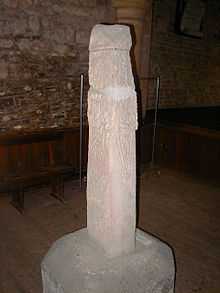
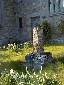
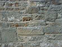
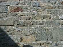
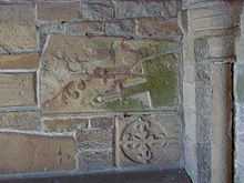
Not much remains of the once thriving settlement at Stanwick except the parish church, the Church of St John The Baptist. The present church dates from the 13th century , although large sections of it were rebuilt during architect Anthony Salvin's major restoration of the building in 1867-8, which was executed under the auspices of the Dowager Duchess of Northumberland who lived at, the now demolished, Stanwick Park. The remains of a 9th centurycross-shaft in the tower and a number of carved stones set into the walls suggest an earlier building may have occupied the site . Its location in an unusual circular churchyard also hints at a possible pre-Norman conquest burial ground. The church has not held regular services since 1990, although it remains consecrated.
Completely surrounding the village of Stanwick St John are Stanwick Iron Age Fortifications, a huge Iron Age hill fort comprising six miles (10 km) of ditches and ramparts enclosing over 700 acres (2.8 km2) of land.
Some archaeologists and historians believe that these massive fortifications enclosed the ancient fort of Rigodunum, the capital of Brigantia, possibly occupied by Cartimandua, Queen of the Brigantes, or her rival and ex-husband, Venutius .
History
Early Period
Traces of the early human occupation of the ancient site now known as Stanwick Camp are everywhere about: the snaking dykes enclose a roughly triangular area of 300 hectares (740 acres) with an internal defensible sector, now a meadow known as the Tofts south of the church. Excavations in 1951 (Wheeler) and during the 1980s (Haselgrove) have revealed traces of round houses both within the Tofts and outside the larger enclosed area suggesting that from about 200BC agrarian settlers began to establish what became the largest oppidum in the north of England. Traces of Samian and other rich goods in one of the round-house remains suggest that Cartimandua, Queen of the Brigantes (who, thanks to a short mention in Tacitus’ history, is known to have made a pact with the rapidly advancing Romans under Petillius Cerealis) may have made it her (temporary) residence. Rigodonum, a Brigantian fort of unknown location mentioned by Tacitus, has been proposed by Mortimer Wheeler as a likely candidate for the location now known as Stanwick. There are here no signs of battle in the archaeological record; the Romans established stations at Catterick to the south and Piercebridge at the river crossing to the north but at about the same time (ca 70AD) building activity seems to have stopped at Stanwick. Another contemporary walled ditch called Scots Dyke running from Stanwick as far south as the river Swale at Richmond (and possibly also north over the Tees at Gainford) may have formed part of a general defensive mechanism for the hill peoples in the area. An English Heritage visitor site just outside the village of Forcett contains a section of the defences rebuilt by Sir Mortimer Wheeler showing how the ditch was at this point actually cut down into the native sandstone and this used for a wall on the inner side. However, the very length of the perimeter of the site (more than 6 km) suggests that defence against a strong attack would hardly have been an option.
(A leaflet ‘Stanwick Camp’ is available from North Yorkshire County Council, countryside@northyorks.gov.uk Articles from the ‘Stanwick Hoard’ discovered nearby in 1854 are to be seen in the British Museum in London, and archaeological reports of digs in the 1980s can be read in the Archaeological Journal 147 (1990), Haselgrove et al.)
Post-Roman
While Stanwick was never an important settlement after the Romans built and marched up what is now called Dere Street, from Catterick fort towards their river crossing at Piercebridge, it seems that the centre of the area below the Tofts, with its watermeadows, stream and pasture, which became built up into the circular, sacred island-like site visible today provided a place for Christian worship and a burial ground as early as 500 AD. Traces of a small Iron Age village have been identified a little to the north-east of the church, and particularly in wet conditions early cultivation patterns are clearly visible in all the surrounding fields. Some very early carved stones with Viking ornamentation are to be seen built into the walls of the chancel and the porch, and an Anglo-Saxon cross-shaft with Celtic scrollwork is in the church.
After the Conquest
As early as 1066 ‘one Tor held 3 carucates of land here at Stanwegge’. (A carucate is a notional area to do with the rate of oxen ploughing, probably around 150 acres). It became Stanwigs and then Stanwick, probably derived from ‘stone walls’. By 1275 the Templars and then by 1348 the Knights Hospitallers took over the settlement, but within the next fifty years it was transferred into the hands of the Catherick family (the village of Catterick lies, with its Roman remains, some five miles (8 km) to the south). They built the Old Hall, still in use, opposite the church where an Elizabeth Catherick is remembered with a brass plate dated 1591.
They finally sold the house and estate to Hugh Smithson, successful ‘citizen and haberdasher’ of London, in 1638, for £4000. His grandfather had lived at Stanwick, so he was coming home. The hamlet was then 600 acres (about 250 hectares) with four dwelling houses and six cottages. By 1750 his great grandson Hugh married Elizabeth Seymour, the daughter of the Earl of Northumberland. The Earl had no male offspring, but quickly changing his name from Smithson to Percy - at a stroke the problem was solved. He qualified for the title of the fourth Baronet - and subsequently became Duke of Northumberland. By 1763 the Royal Arms had been painted above the Chancel (at a cost of £5), the church floor had been flagged, and new pews and a gallery under the tower built.
Despite the fact that the official seat of the Northumberlands was at Alnwick, sixty miles to the north, family ties were important and he moved to build a splendid new Stanwick Hall half a mile to the south which he would use as a country retreat. The beck was bridged and an approach drive constructed to link with the neighbouring village of Aldbrough, Dere Street and the outside world. The new Hall, complete with splendid summerhouse and deer park, was painted upon its completion by George Cuitt the Elder (1743-1818), who was born at nearby Moulton; the picture is to be seen at Syon House, London, to this day.
Soon a new century had arrived, and the gardens were being built – an Italian style sunken garden with fountain immediately south of the entrance; a splendid 1-acre (4,000 m2) walled French Garden (designed allegedly by an émigré French priest – escaping the Revolution?) and a 2-acre (8,100 m2) walled kitchen garden further to the east. Soon the seventh duke was in charge, Algernon, who married Eleanor Grosvenor in 1842, and more alterations began at Stanwick Hall. Perhaps that was when the icehouse was sunk in the Tofts to the SW of the church, with a handsome ornamental ‘Deer Shelter’ on top. He was a naval officer, explorer and social innovator, expanding enormously his estates with the revenue from the coal industry and the railways; he was buried with some pomp in Westminster Abbey, in 1864, leaving the estate ‘for her lifetime’ to his distraught and childless widow.
She did not pause; soon the church was rebuilt (by Anthony Salvin) from its parlous condition, many of the historical stones from the older buildings and tombs being set in its walls and porch. A new Vicarage was built to the north (and presented with a portrait of the late Duke); lodges and stout residences for her Butler and Head Gardener were added. Later, in 1891, she commissioned a new church (St Paul’s) to be built in Aldbrough St John nearby. (That village - itself of ancient foundation - was already largely the property of the Northumberlands. and always had been the source of workers and services for the estate.) An interesting record of the Hall and its land was made in 1900, when Country Life Illustrated's edition of February 17 featured a well-illustrated article entitled 'Stanwick Park, Yorkshire - the seat of Eleanor, Duchess of Northumberland". This included seven photographs of the house and gardens and associated statuary and ironwork. In only one of the published pictures is a living person -Mr William Higgie, her Head Gardener, employed in 1866 and discharged only following her death in 1911.
The Dowager Duchess Eleanor lived on to the age of 90, spending about half the year in residence and seeing to the spiritual needs of the community, reducing the number of pubs to one, supporting the school and dispensing charity to the deserving.
After her death the house was less and less used by the family, and was briefly a hospital for wounded from the First World War. With the severe imposition of death duties after that war the upkeep of the house and grounds became uneconomic and in 1923 the Northumberland family sold all its farms and land in the area; the house failed to find a buyer and was demolished. Most of the associated buildings were successfully sold – the large kitchen garden became a commercial enterprise and the cottages and outbuildings were taken up and converted to modern dwellings. The result was a small nuclear village of some ten properties which has since expanded slightly but still remains within the original estate boundaries. Googling the place still clearly reveals the plan of the estate (minus the house itself).
The neighbouring estate of Carlton, half a mile to the north-east, had been subsumed by Stanwick Hall early in the nineteenth century and was the residence of the overall estate manager, stables and kennels and associated estate staff accommodation. Its fate echoed that of Stanwick: the Hall was demolished and it is now also a group of refurbished estate walls and buildings, including an icehouse and traces of walled gardens.
External links
| Wikimedia Commons has media related to Stanwick St John. |