Stanley, New Brunswick
| Village of Stanley | |
|---|---|
| Village | |
|
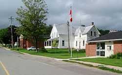
View of Stanley | |
 Stanley Location of Stanley in New Brunswick | |
| Coordinates: 46°27′7.9″N 66°59′2.9″W / 46.452194°N 66.984139°WCoordinates: 46°27′7.9″N 66°59′2.9″W / 46.452194°N 66.984139°W | |
| Country |
|
| Province |
|
| County | York County |
| Parish | Stanley Parish |
| Government | |
| • Type | Village council |
| Area | |
| • Land | 5.74 km2 (2.22 sq mi) |
| Population (2011) | |
| • Total | 419 |
| • Density | 203.3/km2 (527/sq mi) |
| • Change 2006-11 |
|
| Time zone | Atlantic (UTC-4) |
| • Summer (DST) | Atlantic (UTC-3) |
| Area code(s) | Area code 506 |
| Website |
www |
Stanley (2011 population: 419) is a village in York County, in the Canadian province of New Brunswick.
History
Straddling the Nashwaak River 30 km north of Fredericton at the intersection of Route 107 and Route 620. The village is home to the annual Stanley Fair, the longest continuously running agricultural fair in Canada.
The area was colonized in 1833 when a group of London Merchants became interested in the area.
In 1846, 798 square miles (2,070 km2) were established as the Parish of Stanley. By 1951, there were 130 residences, and 149 stores and barns.
There were schools in Tay Creek, North Tay, Fredericksburg, Currieburg, Limekiln, Red Rock, English Settlement, Tay Falls, Tay Valley, Giants Glen, Ward Settlement, Cross Creek, Green Hill, Maple Grove, Williamsburg, and Napadogan.
The first sawmill was constructed at the bottom of Stanley hill in 1856, by the New Brunswick and Nova Scotia Land Company.
Stanley is also home to the Country Market.
Notable people
- Matthew Wuest: Sports reporter and founder of CapGeek