Standhope Peak
| Standhope Peak | |
|---|---|
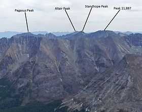 Standhope Peak viewed from Hyndman Peak | |
| Elevation | 11,878 ft (3,620 m)[1] |
| Prominence | 468 ft (143 m)[1] |
| Location | |
 Standhope Peak Custer County, Idaho, U.S. | |
| Range | Pioneer Mountains |
| Coordinates | 43°47′05″N 114°01′30″W / 43.7846305°N 114.0250393°WCoordinates: 43°47′05″N 114°01′30″W / 43.7846305°N 114.0250393°W[2] |
| Topo map | USGS Standhope Peak |
| Climbing | |
| Easiest route | Scramble, class 3 |
Standhope Peak, at 11,878 feet (3,620 m) above sea level is the fourth highest peak in the Pioneer Mountains of Idaho. The peak is located in Salmon-Challis National Forest and Custer County. It is the 20th highest peak in Idaho and about 0.75 mi (1.21 km) northeast of Peak 11,887 and 1 mi (1.6 km) southwest of Altair Peak.[3][4][5]
References
- ↑ 1.0 1.1 "Standhope Peak, Idaho". Peakbagger.com. Retrieved January 1, 2013.
- ↑ "Standhope Peak". Geographic Names Information System. United States Geological Survey. Retrieved January 1, 2013.
- ↑ "The 100 Highest Peaks". Idaho: A Climbing Guide. Retrieved January 1, 2013.
- ↑ Sawtooth National Forest (Map) (1998 ed.). Sawtooth National Forest, U.S. Forest Service.
- ↑ "Standhope Peak". SummitPost.org. Retrieved January 1, 2013.