Stampers Creek Township, Orange County, Indiana
| Stampers Creek Township | |
|---|---|
| Township | |
|
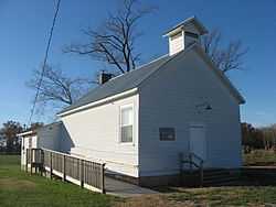
The Lynd School, a historic site in the township | |
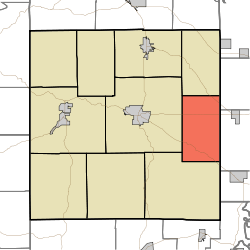 Location in Orange County | |
| Coordinates: 38°32′20″N 86°20′59″W / 38.53889°N 86.34972°WCoordinates: 38°32′20″N 86°20′59″W / 38.53889°N 86.34972°W | |
| Country |
|
| State |
|
| County | Orange |
| Government | |
| • Type | Indiana township |
| Area | |
| • Total | 28.51 sq mi (73.8 km2) |
| • Land | 28.45 sq mi (73.7 km2) |
| • Water | 0.05 sq mi (0.1 km2) 0.18% |
| Elevation | 778 ft (237 m) |
| Population (2010) | |
| • Total | 954 |
| • Density | 33.5/sq mi (12.9/km2) |
| ZIP codes | 47125, 47452, 47454 |
| GNIS feature ID | 0453870 |
Stampers Creek Township is one of ten townships in Orange County, Indiana, United States. As of the 2010 census, its population was 954 and it contained 386 housing units.[1]
History
Stampers Creek Township was named after Stampers Creek, which in turn was named for an obscure area pioneer named Stamper.[2]
Geography
According to the 2010 census, the township has a total area of 28.51 square miles (73.8 km2), of which 28.45 square miles (73.7 km2) (or 99.79%) is land and 0.05 square miles (0.13 km2) (or 0.18%) is water.[1]
Unincorporated towns
- Mahan Crossing at 38°33′26″N 86°21′52″W / 38.557278°N 86.364429°W
- Millersburg at 38°33′26″N 86°20′08″W / 38.557279°N 86.33554°W
- Trotter Crossing at 38°30′41″N 86°21′56″W / 38.511446°N 86.36554°W
(This list is based on USGS data and may include former settlements.)
Cemeteries
The township contains these two cemeteries: Copelin and Danners.
Major highways
School districts
- Paoli Community School Corporation
Political districts
- Indiana's 9th congressional district
- State House District 62
- State Senate District 44
References
- "Stampers Creek Township, Orange County, Indiana". Geographic Names Information System. United States Geological Survey. Retrieved 2009-10-17.
- United States Census Bureau 2008 TIGER/Line Shapefiles
- IndianaMap
- ↑ 1.0 1.1 "Population, Housing Units, Area, and Density: 2010 - County -- County Subdivision and Place -- 2010 Census Summary File 1". United States Census. Retrieved 2013-05-10.
- ↑ History of Lawrence, Orange, and Washington Counties, Indiana: From the Earliest Time to the Present. Higginson Book Company. 1884. p. 405.
External links
- Indiana Township Association
- United Township Association of Indiana
- City-Data.com page for Stampers Creek Township
 |
Northeast Township | Vernon Township, Washington County | | |
| Paoli Township | |
Madison Township, Washington County | ||
| ||||
| | ||||
| Southeast Township | |
| |||||||||||||||||||||