Stamna, Greece
| Stamna Σταμνά | |
|---|---|
 | |
 Stamna | |
|
Location within the region | |
| Coordinates: 38°31′N 21°17′E / 38.517°N 21.283°ECoordinates: 38°31′N 21°17′E / 38.517°N 21.283°E | |
| Country | Greece |
| Administrative region | West Greece |
| Regional unit | Aetolia-Acarnania |
| Municipality | Missolonghi |
| Municipal unit | Aitoliko |
| Elevation | 104 m (341 ft) |
| Population (2001)[1] | |
| • Rural | 939 |
| Time zone | EET (UTC+2) |
| • Summer (DST) | EEST (UTC+3) |
| Postal code | 304 00 |
| Area code(s) | 26320 |
| Vehicle registration | ΜΕ |
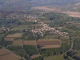
Stamna (Greek: Σταμνά) is a village and a community in the municipal unit of Aitoliko in the southern part of Aetolia-Acarnania, Greece. It is located on a chain of low hills that separate the river Acheloos to the west from the bay of Aitoliko to the southeast. It is 6 km south of Angelokastro, 11 km northwest of Aitoliko, 17 km southwest of Agrinio and 21 km northwest of Missolonghi. The Ionia Odos motorway (Missolonghi - Amfilochia) passes east of the village. The community Stamna consists of the villages Stamna, Stathmos Stamnas (1.5 km east, near the former railway station) and Kefalovrysos (4 km southeast, at the bay). Stamna had a train station on the former railway from Missolonghi to Agrinio.
Historical population
| Year | Village population | Community population |
|---|---|---|
| 1981 | - | 1,321 |
| 1991 | 991 | - |
| 2001 | 939 | 1,156 |
See also
References
- ↑ De Facto Population of Greece Population and Housing Census of March 18th, 2001 (PDF 39 MB). National Statistical Service of Greece. 2003.
External links
| ||||||||||||||