Stab, Kentucky
| Stab | |
|---|---|
| Unincorporated community | |
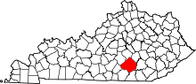
 Stab Location within the state of Kentucky | |
| Coordinates: 37°9′5″N 84°26′13″W / 37.15139°N 84.43694°WCoordinates: 37°9′5″N 84°26′13″W / 37.15139°N 84.43694°W | |
| Country | United States |
| State | Kentucky |
| County | Pulaski |
| Elevation | 837 ft (255 m) |
| Time zone | Central (CST) (UTC-6) |
| • Summer (DST) | CST (UTC-5) |
| ZIP codes | 42557 |
| GNIS feature ID | 515642[1] |
Stab is an unincorporated community in Pulaski County, Kentucky, United States.
History
A post office called Stab was established in 1922, and remained in operation until it was discontinued in 1994.[2] The name Stab was chosed in part for its brevity; the first choice had been rejected as too long by postal authorities.[3]
References
- ↑ U.S. Geological Survey Geographic Names Information System: Stab, Kentucky
- ↑ "Pulaski County". Jim Forte Postal History. Retrieved 27 April 2015.
- ↑ "World's shortest creek in Stab". The Telegraph. May 8, 1980. p. 21. Retrieved 27 April 2015.
| |||||||||||||||||||||||||