St Mary's, Southampton
| St. Mary's | |
 St Mary's Fire Station |
|
 St. Mary's |
|
| Unitary authority | Southampton |
|---|---|
| Ceremonial county | Hampshire |
| Region | South East |
| Country | England |
| Sovereign state | United Kingdom |
| Post town | SOUTHAMPTON |
| Postcode district | SO14 |
| Dialling code | 023 |
| Police | Hampshire |
| Fire | Hampshire |
| Ambulance | South Central |
| EU Parliament | South East England |
| UK Parliament | Southampton Itchen |
Coordinates: 50°54′20″N 1°23′47″W / 50.9056°N 1.3965°W
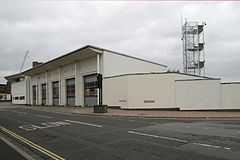
St Mary's is an area of Southampton in England. It consists of two areas separated by Six Dials junction. The northern section of the district is literally St Mary's Road and some streets to the west - the area to the east is Nicholstown-Newtown. The northern section is home to the fire station.
The majority of St Mary's is in the southern portion, to the east of St Mary Street. This is where St Mary's church is located, from which the suburb's name originates. The southern section is also home to the Golden Grove area. It is bordered on the east by the rail lines (the other side of these lines is the district of Chapel). It gives its name to St Mary's Stadium, where Southampton Football Club play, although the stadium itself is in the neighbouring suburb of Northam. St Mary's Church one of two Christian Churches in the area the other being St Michael's 1000 years old Saxon church are members of the local parochial council which serves many Christians in the area as well as many West African people.The church has peels of bells which ring on a Monday night bell practice. Famed for the bells of St Mary's sang by Bing Crosby.
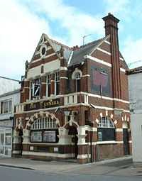
The area also includes the Joiners Arms at 141 St Mary's Street, one of Southampton's main music venues.
References
| ||||||||||||||||||||||||||||||||||