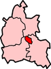
St John Street area
| St John Street area | |
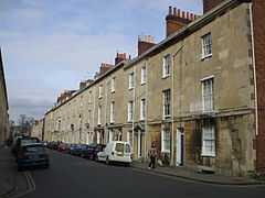 Looking north along St John Street |
|
 St John Street area |
|
| OS grid reference | SP510065 |
|---|---|
| Civil parish | unparished |
| District | Oxford |
| Shire county | Oxfordshire |
| Region | South East |
| Country | England |
| Sovereign state | United Kingdom |
| Post town | Oxford |
| Postcode district | OX1 |
| Dialling code | 01865 |
| Police | Thames Valley |
| Fire | Oxfordshire |
| Ambulance | South Central |
| EU Parliament | South East England |
| UK Parliament | Oxford West and Abingdon |
| Website | Oxford City Council |
|
|
Coordinates: 51°45′22″N 1°15′43″W / 51.756°N 1.262°W
The St John Street area is a residential area close to the city centre in Oxford, England. It consists of two streets, St John Street and Beaumont Buildings. Wellington Square is to the north, Pusey Street to the east, and Beaumont Street to the south.
It is an area of terraced houses developed in about 1830 as part of the same scheme as Beaumont Street.[1][2]
References
Sources and further reading
- Crossley, Alan; Elrington, C.R. (eds.); Eleanor Chance, Christina Colvin, Janet Cooper, C.J. Day, T.G. Hassall, Nesta Selwyn (1979). Victoria County History: A History of the County of Oxford, Volume 4.
- Sherwood, Jennifer; Pevsner, Nikolaus (1974). The Buildings of England: Oxfordshire. Harmondsworth: Penguin Books. p. 324. ISBN 0-14-071045-0.
- Tyack, Geoffrey (1998). Oxford An Architectural Guide. Oxford & New York: Oxford University Press. p. 204. ISBN 0-19-817423-3.
| ||||||||||||||||||||||||||||||