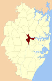
St John Parish, Cumberland
| St John New South Wales | |||||||||||||
|---|---|---|---|---|---|---|---|---|---|---|---|---|---|
|
Location of the parish within Cumberland | |||||||||||||
| Established | 1835 | ||||||||||||
| LGA(s) | City of Parramatta | ||||||||||||
| County | Cumberland | ||||||||||||
| Hundred (former) | Parramatta | ||||||||||||
| |||||||||||||
St John Parish is one of the 57 parishes of Cumberland County, New South Wales, a cadastral unit for use on land titles. It is named after St John's[1] Anglican church in Parramatta, which opened in 1803. The parish is shaped like a "T", with the northern part stretching from Toongabbie to near Homebush Bay. The southern end is at Prospect Creek near Yennora. Woodville Road and Parramatta Road form the boundaries to the south-east. The Old Prospect Road is part of the boundary in the west. It includes the suburbs of Merrylands, Parramatta, Silverwater, Westmead, Fairfield East and Guildford.
Coordinates: 33°49′54″S 151°03′04″E / 33.83167°S 151.05111°E
References
- "St John". Geographical Names Register (GNR) of NSW. Geographical Names Board of New South Wales.
