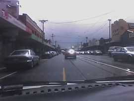
St Georges Road, Melbourne
| St Georges Road Victoria | |
|---|---|
 | |
| St Georges Road | |
| General information | |
| Type | Road |
| Length | 6 km (4 mi) |
| Route number(s) |
|
| Major junctions | |
| North end |
Murray Road, Preston, Melbourne |
| |
| South end |
|
| Location(s) | |
| Major suburbs | Thornbury, Northcote |
St Georges Road is a main road in the inner northern suburbs of Melbourne, which passes through the suburbs of Fitzroy North, Northcote, Thornbury and Preston. The road is designated State Route 45 for its entire length, although carries State Route 38 for approximately 500 metres as it crosses Merri Creek.
The southern end commences at the intersection of York Street and Nicholson Street in Fitzroy North. Branching diagonally from Nicholson Street, the street proceeds in a roughly north-north-east direction, crossing Brunswick Street at Watkins Street. Here, it becomes a major thoroughfare and the 112 tram route enters the street. It continues in the same direction until it crosses Merri Creek. Just after crossing Merri Creek there is an intersection with Merri Parade and Charles Street. St Georges Road then continues more directly north as a divided road until it terminates at Murray Road, Preston, where it joins Spring Street.[1] The local council, the City of Yarra, has planted trees between Merri Bridge and Holden Street.
Northcote High School is situated on St Georges Road. Located nearby is Merri Creek Primary School. Some small shopping areas are located along the road.
Until the middle of 2009 there was a large roundabout at the intersection of St Georges Road, Merri Parade and Charles Street which has now been replaced by traffic lights.
- Images
-

-

-

See also
Australian roads portal
References
- ↑ Melway (Edition 33, 2006) maps 18 and 30. ISBN 0-909439-14-1