St. Peter's Island
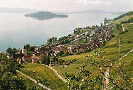 St. Peter’s Island as seen from Twann | |
 Location in Switzerland | |
| Geography | |
|---|---|
| Location | Lake Biel |
| Highest elevation | 474 m (1,555 ft) |
| Country | |
| Canton | Bern |
| Districts |
Biel/Bienne Seeland |
St. Peter’s Island (German: St. Petersinsel, French: Île de St-Pierre) is a peninsula and former island situated in Lake Biel in the canton of Bern, Switzerland. It has a length of about 5 kilometres and a maximum width of 800 metres. Its highest point is 474 metres above sea level or 45 metres above lake level (429 m). It was formed in the last Ice Age (see Pleistocene), when the Rhône Glacier reached as far as the Jura mountains. It is a promontory of the Jolimont, above Erlach. Politically the island is split between the municipalities of Erlach and Twann-Tüscherz, the largest part belonging to the latter municipality.
In the late nineteenth century following the engineering works of the Jura water correction, the water-level of the three lakes of the Seeland have dropped enough to clear the until then hidden isthmus, linking Erlach to St. Peter’s Island, which has eversince become a peninsula, although separated from the shore by a canal.
Monks of the Cluniac order were the first inhabitants of the island, and built a monastery here in 1127.
Before his expulsion, Jean-Jacques Rousseau, spent two months on the island in 1765 calling it the "happiest time of his life".[1]
References
| Wikimedia Commons has media related to St. Peter's Island. |
- ↑ "Rousseau's Expulsion from the Ile Saint-Pierre" Edward D. Seeber M.L.N., Vol. 79, No. 5, (December 1964), pp. 539-543
- Swisstopo topographic maps
External links
Coordinates: 47°04′15″N 7°08′33″E / 47.07083°N 7.14250°E