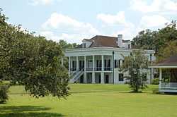
St. Emma Plantation
|
St. Emma | |
 | |
 | |
| Nearest city | Donaldsonville, Louisiana |
|---|---|
| Coordinates | 30°5′2″N 91°1′50″W / 30.08389°N 91.03056°WCoordinates: 30°5′2″N 91°1′50″W / 30.08389°N 91.03056°W |
| Area | 0.5 acres (0.20 ha) |
| Built | 1850 |
| Architectural style | Greek Revival, Other, Raised plantation house |
| Governing body | Private |
| NRHP Reference # | 80001695[1] |
| Added to NRHP | June 30, 1980 |
St. Emma Plantation is a 13,000-acre (5,300 ha) former sugar plantation and house near Donaldsonville, Louisiana, United States.[2]
Listed on National Register of Historic Places in 1980. Scene of Civil War skirmish in fall of 1862. C 1850[3] Greek Revival plantation house owned 1854-1869 by Charles A. Kock, a prominent sugar planter.[4]
References
- ↑ "National Register Information System". National Register of Historic Places. National Park Service. 2010-07-09.
- ↑ Martinez, Raymond J.; Jack D.L. Holmes (1969). New Orleans: Facts & Legends. Pelican Publishing. p. 136.
- ↑ Daspit, Fred (2006). Louisiana architecture, 1840-1860. University of Louisiana at Lafayette. p. 263. ISBN 9781887366748.
- ↑ http://www.waymarking.com/waymarks/WM4BKE_St_Emma_Plantation Louisiana State Historical Marker, located in front of plantation.
| ||||||||||||||||||||||||||