Squaw Creek National Wildlife Refuge
| Squaw Creek National Wildlife Refuge | |
|---|---|
|
IUCN category IV (habitat/species management area) | |
|
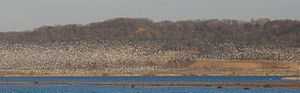
Snow Geese against the Loess Hills | |
 Map of the United States | |
| Location | Holt County, Missouri, USA |
| Nearest city | Mound City, Missouri |
| Coordinates | 40°04′08″N 95°13′34″W / 40.068778°N 95.226102°WCoordinates: 40°04′08″N 95°13′34″W / 40.068778°N 95.226102°W |
| Area | 3,400 acres (14 km2) |
| Established | 1935 |
| Governing body | U.S. Fish and Wildlife Service |

Squaw Creek National Wildlife Refuge is a National Wildlife Refuge in northwestern Missouri, USA, established in 1935 by President Franklin D. Roosevelt as a refuge and breeding ground for migratory birds and other wildlife.
The refuge comprises 7,350 acres (30 km2) along the eastern edge of the Missouri River floodplain south of Mound City, Missouri in Holt County, Missouri.
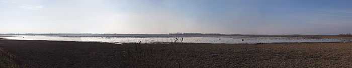
The refuge is bounded by the Loess Hills on the east with a trail going to the top built originally by the Civilian Conservation Corps. The most dramatic moments occur during spring and fall migrations, when the refuge serves as a chokepoint for hundreds of thousands of ducks and geese (particularly snow geese) on the Central Flyway. As many as 475 bald eagles have been sighted on the refuge in the winter. The refuge annually celebrates the eagle visits with "Eagle Days" celebrations. In February 2013, over one million snow geese were counted.[1]
The refuge derives its name from Squaw Creek, a stream originating about 30 miles (48 km) north in Nodaway County, Missouri that is dammed to form the reservoirs. The creek is the larger of the two main creeks that feed the refuge and parallels the road on the west. Davis Creek, the next biggest creek, parallels the east side road. They merge with the Little Tarkio Creek just south of the refuge in a man made ditch leading five miles (8 km) to the Missouri River.
The land which had always been wetlands used by migratory foul had earlier been used as a private hunting preserve. Today ducks and geese are protected at the refuge but several hunting preserves are just outside its boundaries.[2]
Among the construction at the refuge were 15 impoundments totaling 3,400 acres (14 km2), construction of 14 miles (23 km) of dikes and levees and 11 miles (18 km) of ditches.
The headquarters area includes a 100-seat auditorium and 875 square feet (81 m2) of exhibit space (the University of Missouri also has Squaw Creek exhibits as does the St. Joseph Museum in St. Joseph, Missouri, which has a Squaw Creek diorama). A 0.25-mile (0.40 km) trail built by the Civilian Conservation Corps climbs 200 feet (60 m) vertically to a refuge overlook from which you can see Missouri, Kansas, and Nebraska.
A one-way 10-mile (16 km) gravel road (the "Wild Goose Tour Loup") travels around the edge of the refuge. The refuge reports that 134,245 visited in 2001 with 41,683 at the headquarters.
Changing the name of Squaw which was toyed with at one time is not an active point of contention with Native Americans. The Iowa (tribe) who operate the Casino White Cloud on a reservation in neighboring White Cloud, Kansas in 2004 re-opened the Squaw Creek Truck Plaza, which was a landmark at the refuge exit on Interstate 29 that had been shuttered for several years.[3]
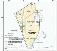 Map of the refuge |
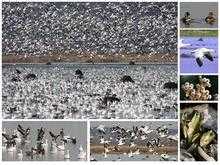 Squaw Creek Scenes 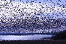 Snow geese at Bluff Pool. The refuge is a chokepoint for Central Flyway migration. |
References
- ↑ Squaw Creek Waterfowl Count by the U.S. Fish & Wildlife Service; 11 February 2013 count for 1,003,600 snow geese
- ↑ Squaw Creek National Wildlife Refuge Comprehensive Conservation Plan
- ↑ Missouri Department of Natural Resources Permit MO-0103683
External links
| Wikimedia Commons has media related to Squaw Creek National Wildlife Refuge. |