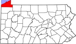
Springfield Township, Erie County, Pennsylvania
| Springfield Township | |
|---|---|
| Township | |
|
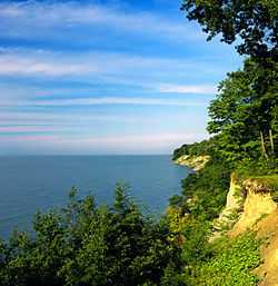
Lake Erie bluffs as seen from the David M. Roderick Wildlife Reserve | |
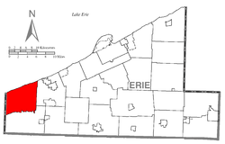 Location of Springfield Township in Erie County | |
| Country | United States |
| State | Pennsylvania |
| County | Erie |
| Area | |
| • Total | 37.7 sq mi (98 km2) |
| • Land | 37.4 sq mi (97 km2) |
| • Water | 0.3 sq mi (0.8 km2) |
| Population (2010) | |
| • Total | 3,425 |
| • Density | 91/sq mi (35/km2) |
| Time zone | EST (UTC-4) |
| • Summer (DST) | EDT (UTC-5) |
| Area code(s) | 814 |
Springfield Township is a township in Erie County, Pennsylvania, United States. The population was 3,425 at the 2010 census.
Geography
According to the United States Census Bureau, the township has a total area of 37.7 square miles (97.5 km²), of which, 37.4 square miles (96.8 km²) of it is land and 0.3 square miles (0.7 km²) of it (0.24%) is water.
History
Springfield's early history and development was tied to the construction of the Erie Canal in the early 19th century and the commerce that resulted from it. A notable example of its past is passage through Springfield for work related to the canal of James Hutchinson Woodworth, a former farmer and teacher from Onondaga County, New York, who was making his way West to Chicago where he finally settled and eventually become Mayor. William Blakely Holliday of Springfield, PA also made a major impact on how the township was formed. He purchased land off of the Native Americans in 1806 A.D. William Holiday owned most all of East and North Springfield. The Holliday family still resides in North Springfield today.
Demographics
As of the census[1] of 2000, there were 3,378 people, 1,253 households, and 943 families residing in the township. The population density was 89.6 people per square mile (34.6/km²). There were 1,462 housing units at an average density of 38.8/sq mi (15.0/km²). The racial makeup of the township was 97.87% White, 0.62% African American, 0.21% Native American, 0.27% Asian, 0.27% from other races, and 0.77% from two or more races. Hispanic or Latino of any race were 0.56% of the population.
There were 1,253 households out of which 34.3% had children under the age of 18 living with them, 59.9% were married couples living together, 10.6% had a female householder with no husband present, and 24.7% were non-families. 20.7% of all households were made up of individuals and 8.0% had someone living alone who was 65 years of age or older. The average household size was 2.70 and the average family size was 3.11.
In the township the population was spread out with 26.7% under the age of 18, 7.0% from 18 to 24, 29.3% from 25 to 44, 24.8% from 45 to 64, and 12.1% who were 65 years of age or older. The median age was 37 years. For every 100 females there were 101.8 males. For every 100 females age 18 and over, there were 102.6 males.
The median income for a household in the township was $39,872, and the median income for a family was $42,352. Males had a median income of $36,491 versus $21,786 for females. The per capita income for the township was $17,389. About 6.6% of families and 9.3% of the population were below the poverty line, including 9.9% of those under age 18 and 11.1% of those age 65 or over.
References
- ↑ "American FactFinder". United States Census Bureau. Retrieved 2008-01-31.
| |||||||||||||||||||||||||||||
Coordinates: 41°58′00″N 80°30′29″W / 41.96667°N 80.50806°W