Springfield, Louisiana
| Town of Springfield | |
| Town | |
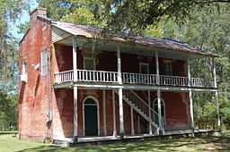 Old Livingston Parish Courthouse in Springfield | |
| Country | United States |
|---|---|
| State | Louisiana |
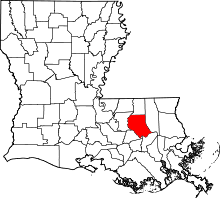
| Parish | Livingston |
| Elevation | 16 ft (4.9 m) |
| Coordinates | 30°25′45″N 90°32′53″W / 30.42917°N 90.54806°WCoordinates: 30°25′45″N 90°32′53″W / 30.42917°N 90.54806°W |
| Area | 1.40 sq mi (3.6 km2) |
| - land | 1.40 sq mi (4 km2) |
| - water | 0.00 sq mi (0 km2), 0% |
| Population | 487 (2010) |
| Density | 347.1 / sq mi (134 / km2) |
| Timezone | CST (UTC-6) |
| - summer (DST) | CDT (UTC-5) |
| Area code | 225 |
 Location of Springfield in Louisiana
| |
 Location of Louisiana in the United States
| |
Springfield is a town in Livingston Parish, Louisiana, United States. The population was 487 at the 2010 census. It is part of the Baton Rouge Metropolitan Statistical Area.
Geography
Springfield is located at 30°25′45″N 90°32′53″W / 30.42917°N 90.54806°W (30.429173, -90.548065).[1]
According to the United States Census Bureau, the town has a total area of 1.4 square miles (3.6 km²), all of it land.
The town's name comes from the numerous artesian springs in the area.
The ZIP Code of Springfield is 70462.
History
Springfield began in the 17th century at one of the northernmost points considered to be navigable on the Natalbany River. Between Springfield and Lake Maurepas, Ponchatoula Creek joins the Natalbany and increases its flow.
Via the Natalbany, Lake Maurepas, Lake Ponchartrain, and Bayou Saint John, Springfield had access to New Orleans by water. Similarly, at the time (prior to the damming of the channel by levees) along the Amite River and Mississippi River, Bayou Manchac provided shallow-water access between Springfield and Baton Rouge. By 1810 Springfield was one of the areas of interest in the rebellion against Spain, which produced the short-lived Republic of West Florida. Bricks from an old Spanish fort can still be found roughly 200 yards in front of the current post office.
Springfield was the seat of Livingston Parish on the incorporation of the Republic of West Florida into the State of Louisiana in 1810. A post office was listed in Springfield, Livingston County (Parish) on October 1, 1846, with Jacob P. Randolph as the postmaster.[2]
In the early part of the 19th century, Peter av Hammerdal (Peter Hammond), eponym of Hammond, Louisiana, came to do business of transporting merchandise to oceangoing vessels in New Orleans. The Springfield city fathers, fearing a lawless element, declined to allow a railway track to be laid from New Orleans through Springfield and then north. This decision gave birth to Ponchatoula, Hammond, Amite, and other towns, as the train line bypassed Springfield. The 1854 completion of the New Orleans, Jackson & Great Northern Railroad (now the Canadian National Railway)—which went through Hammond, Ponchatoula, and Manchac—bypassed Springfield and deprived it of a logistical role.
When Tangipahoa Parish was formed partly from Livingston Parish in 1868, Springfield was no longer a central location in Livingston Parish. It sat along the new boundary between Livingston and Tangipahoa Parishes.
Current
As of November 2012, the old courthouse still stands, a two-story building in Springfield's southeast quadrant.
Demographics
As of the census[3] of 2000, there were 395 people, 162 households, and 115 families residing in the town. The population density was 282.4 people per square mile (108.9/km²). There were 185 housing units at an average density of 132.3 per square mile (51.0/km²). The racial makeup of the town was 96.20% White, 2.03% African American, 0.25% Asian, and 1.52% from two or more races.
There were 162 households out of which 27.8% had children under the age of 18 living with them, 51.9% were married couples living together, 12.3% had a female householder with no husband present, and 28.4% were non-families. 25.9% of all households were made up of individuals and 11.1% had someone living alone who was 65 years of age or older. The average household size was 2.44 and the average family size was 2.90.
In the town the population was spread out with 23.5% under the age of 18, 8.1% from 18 to 24, 24.1% from 25 to 44, 28.4% from 45 to 64, and 15.9% who were 65 years of age or older. The median age was 41 years. For every 100 females there were 101.5 males. For every 100 females age 18 and over, there were 89.9 males.
The median income for a household in the town was $28,125, and the median income for a family was $48,750. Males had a median income of $35,536 versus $21,667 for females. The per capita income for the town was $17,075. About 19.0% of families and 20.8% of the population were below the poverty line, including 35.2% of those under age 18 and 15.6% of those age 65 or over.
Education
Springfield is within the Livingston Parish Public Schools system.
Springfield is served by:
- Springfield Elementary School
- Springfield Junior High School
- Springfield High School
External links
| Wikimedia Commons has media related to Springfield, Louisiana. |
| |||||||||||||||||||||||||||||
References
- ↑ "US Gazetteer files: 2010, 2000, and 1990". United States Census Bureau. 2011-02-12. Retrieved 2011-04-23.
- ↑ "Table of Post Offices in the United States (1846)". Public domain, Google books (http://books.google.com)''. John T. Tower (Printer, US Government). 1846. p. 208. Retrieved June 29, 2014.
- ↑ "American FactFinder". United States Census Bureau. Retrieved 2008-01-31.