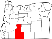
Sprague River, Oregon
| Sprague River | |
|---|---|
| Unincorporated community | |
 Sprague River Location within the state of Oregon | |
| Coordinates: 42°27′20″N 121°30′11″W / 42.45556°N 121.50306°WCoordinates: 42°27′20″N 121°30′11″W / 42.45556°N 121.50306°W | |
| Country | United States |
| State | Oregon |
| County | Klamath |
| Elevation[1] | 4,354 ft (1,327 m) |
| Time zone | Pacific (PST) (UTC-8) |
| • Summer (DST) | PDT (UTC-7) |
| GNIS feature ID | 1150145 |
Sprague River is an unincorporated community in Klamath County, Oregon, United States.[1] It is located about 45 miles (72 km) northeast of Klamath Falls near the Sprague River, northwest of Oregon Route 140.
History
The Sprague River was named for Captain Franklin B. Sprague, who participated in the Snake and Paiute Indian wars, and was in command of Fort Klamath in 1866.[2] His name was applied to the river by 1864, and perhaps earlier.[2] The Klamath name for the stream was Plai or Plaikni Koke.[2] Koke was the generic word for "river" and plai meant the river came from upper or higher country.[2] Sprague River post office, named after the stream, was established September 14, 1923, with Benjamin E. Wolford as the first postmaster.[2] There was an earlier post office named Sprague River much farther east and upstream of the current community.[2] The Oregon, California and Eastern Railway had a station nearby.[2] The former rail line is now the OC&E Woods Line State Trail.
At one time there was a sawmill and a box factory in the community.[3]
References
- ↑ 1.0 1.1 "Sprague River". Geographic Names Information System. United States Geological Survey. November 28, 1980. Retrieved July 15, 2011.
- ↑ 2.0 2.1 2.2 2.3 2.4 2.5 2.6 McArthur, Lewis A.; McArthur, Lewis L. (2003) [First published 1928]. Oregon Geographic Names (7th ed.). Portland, Oregon: Oregon Historical Society Press. p. 904. ISBN 9780875952772. OCLC 53075956.
- ↑ Lamm, W.E. (c. 1944), Lumbering in Klamath (Pamphlet), p. 20
External links
- Sprague River Online (community Website)
| |||||||||||||||||||||
