Spišské Podhradie
| Spišské Podhradie | ||
| Town | ||
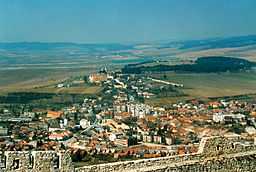 View on Spišské Podhradie from Spiš Castle | ||
|
||
| Country | Slovakia | |
|---|---|---|
| Region | Prešov | |
| District | Levoča | |
| Elevation | 430 m (1,411 ft) | |
| Coordinates | 49°00′00″N 20°45′06″E / 49.00000°N 20.75167°ECoordinates: 49°00′00″N 20°45′06″E / 49.00000°N 20.75167°E | |
| Area | 24.94 km2 (9.63 sq mi) | |
| Population | 3,826 (2006) | |
| Density | 153 / km2 (396 / sq mi) | |
| First mentioned | 1249 | |
| Mayor | Mgr. Jozef Bača | |
| Postal code | 05301 | |
| Area code | +421-53 | |
| Car plate | LE | |
  Location of Spišské Podhradie in Slovakia
| ||
_-_background_map.png) _-_outline_map.svg.png) Location of Spišské Podhradie in the Eastern part of the Prešov Region
| ||
| Wikimedia Commons: Spišské Podhradie | ||
| Statistics: MOŠ/MIS | ||
| Website: www.spisskepodhradie.sk | ||

Spišské Podhradie (German: Kirchdorf; Hungarian: Szepesváralja) is a town in Spiš in the Prešov Region of Slovakia. Its population is 3,826.
Spišské Podhradie is situated at the foot of the hill of Spiš Castle. It had a Zipser German settlement, with its own church and priest, in 1174. Just above, and adjacent to, the town is the ecclesiastical settlement of Spišská Kapitula (hence the town's German name of Kirchdorf, meaning "church town"). The town contains a number of Renaissance merchants' houses. It also has one of the few remaining synagogue buildings (now disused) in the region.
Twin towns — Sister cities
Spišské Podhradie is twinned with:
-
 Głogów Małopolski, Poland
 -
 Pinetop-Lakeside, Arizona, United States
 - Show Low, Arizona, United States
-
 Vrbové, Slovakia
Pictures
-
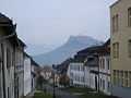
Town center with Spiš Castle above
-
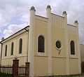
Synagogue at Spišské Podhradie
-
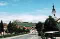
Town center and Spiš Castle above