Spencer Street, Melbourne
| Spencer Street Victoria | |
|---|---|
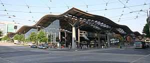 | |
| The intersection of Spencer and Collins Street, looking North West toward Southern Cross Station | |
| General information | |
| Type | Street |
| Length | 2 km (1 mi) |
| Route number(s) |
|
| Major junctions | |
| NW end | Dynon Road and Dryburgh Street, West Melbourne |
| SE end | Whiteman Street and Normanby Road, Southbank |
| Location(s) | |
| Suburb(s) | Melbourne CBD |
Spencer Street is a major street in the central business district of Melbourne, Victoria, Australia. It is named for John Spencer, 3rd Earl Spencer, Chancellor of the Exchequer under Lord Melbourne, the Prime Minister of the United Kingdom.
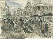
Spencer Street was the site of the first permanent buildings in the settlement now called Melbourne. The home of John Batman was built on nearby Batman's Hill where he lived until his death and the early camps of Captain William Lonsdale and Charles La Trobe were located along the street.[1]
Important buildings on Spencer Street include Southern Cross Station (formerly Spencer Street Station), the offices of The Age newspaper, the former Mail Exchange, Grand Hotel (former Victorian Railways administration offices[2]), the former Sir Charles Hotham Hotel and the HM Melbourne Assessment Prison.
History
The street was once considered an unfashionable and unattractive end of town, but with the construction of Melbourne Docklands, Southern Cross Station and a shopping complex (formerly DFO), and demolition of eyesores such as the power station, several high rise apartment buildings have been built since the late 1990s.
The street was also home to the 1890 era Spencer Street Power Station which has been abandoned since 1982. The power station was asbestos-ridden, with demolition beginning in 2006.
Geography
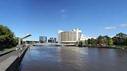
Running roughly from north to south, Spencer Street forms the western edge of the Hoddle Grid. To the north Spencer Street becomes Dynon Road, and to the south it becomes Clarendon Street after crossing the Spencer Street Bridge over the Yarra River.
See also
Australian roads portal
References
- ↑ Spencer Street City of Melbourne
- ↑ Geoff Peterson (February 1993). "67 Spencer Street". Newsrail (Australian Railway Historical Society (Victorian Division)): pages 44–45.
| ||||||||||||||||||