Spaulding Turnpike
| |
|---|---|
|
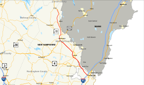
Map of eastern New Hampshire with Spaulding Turnpike highlighted in red | |
| Route information | |
| Maintained by New Hampshire DOT | |
| Length: | 33.2 mi[1] (53.4 km) |
| Existed: | ca. 1956 – present |
| Major junctions | |
| South end: |
|
|
| |
| North end: |
|
| Location | |
| Counties: | Rockingham, Strafford |
| Highway system | |

.jpg)
The Spaulding Turnpike is a toll road in New Hampshire, USA, running 33 miles (53 km) from Interstate 95 in Portsmouth northwest to Milton. The turnpike roughly parallels the Maine border, and in the mid-1990s New Hampshire Route 16 was re-signed onto the turnpike. There are two toll plazas on the turnpike, in Dover and Rochester.
The turnpike is part of the New Hampshire Turnpike System operated by the New Hampshire Department of Transportation Bureau of Turnpikes. It is a 4-lane divided highway from Portsmouth to Rochester. Widening of the turnpike to four lanes between exit 12 at NH Route 125 south of Rochester to north of exit 16 at US 202 north of Rochester was completed in the fall of 2012. The remainder of the highway north to its terminus in Milton is a two-lane freeway. Route 16 continues as an all-access highway north of Milton.
Exit 1, on the border between Portsmouth and Newington, was previously an at-grade crossing with traffic lights, most likely due to the proximity of the entrance to Pease Air Force Base. After the base's closure, it was converted into a diamond interchange.
Concurrent routings
Southern terminus
Signage on I-95 suggests that the Spaulding Turnpike, Route 16, and U.S. Route 4 all begin at the same point. However:
- Milepost readings indicate that the Spaulding Turnpike begins on the Exit 4 northbound offramp from I-95, approximately 1/4 mile north of the junction, and runs by itself for approximately 0.8 miles before joining Route 16. Southbound ground signage also indicates that the Spaulding Turnpike continues at the right-hand split for I-95 South, ending approximately 1/4 mile shy of the merge with I-95 southbound.
- Signage at the Portsmouth Circle for the freeway now reads (Route 16 North TO Spaulding Turnpike and US-4). This implies that Route 16 begins at the circle and approaches the turnpike from the right. Southbound ground signage indicates Route 16 continues at the left-hand split for I-95 North and US-1 Bypass, ending at the traffic circle. No end signage or milepost is present.
- The first westbound signage for U.S. Route 4 is where the Spaulding Turnpike and Route 16 join up; presumably this is where US-4 West begins. The last eastbound signage is before the split for I-95. No end signage is present; presumably US-4 East ends at the point where the split occurs.
Concurrent routes
- U.S. Route 4 runs along the Turnpike from the I-95 split northward for a distance of approximately 6 miles. US-4 departs the Turnpike at Exit 6W northbound (and joins at Exit 6 southbound), near the Dover barrier toll.
- U.S. Route 202 runs along the Turnpike for approximately 2.5 miles, between Exits 13 and 16.
- Route 11 runs along the Turnpike (also concurrent with US-202) for approximately 3/4 mile, between Exits 15 and 16.
Exit list
| County | Location | mi | km | Old exit[2][3] | New exit | Destinations | Notes |
|---|---|---|---|---|---|---|---|
| Rockingham | Portsmouth | 0.00– 0.77 | 0.00– 1.24 | — | Portsmouth Traffic Circle; southern terminus of US 4 concurrency | ||
| 0.92 | 1.48 | — | Brady Drive | Northbound exit and entrance only | |||
| Newington | 1.59 | 2.56 | 1 | Gosling Road – Pease International Tradeport | |||
| 2.38 | 3.83 | 2 | Fox Run Road | Northbound exit and entrance only | |||
| 2.86 | 4.60 | 3 | Woodbury Avenue | Left exit; Southbound exit and northbound entrance only | |||
| 3.45 | 5.55 | 4 | Newington Village | ||||
| Strafford | Dover | 4.39 | 7.07 | 5 | Hilton Park | No southbound exit | |
| 4.76– 5.01 | 7.66– 8.06 | 3 | 6 | Northern terminus of US 4 concurrency; signed as exits 6N (Dover) and 6W (US 4); originally exit 2 | |||
| Dover toll plaza | |||||||
| 9.14 | 14.71 | 4 | 7 | ||||
| 9.45 | 15.21 | 5 | 8 | Signed as exits 8E (east) and 8W (west) | |||
| 12.24 | 19.70 | 6 | 9 | ||||
| Rochester | Rochester toll plaza | ||||||
| 18.20 | 29.29 | 11 | Old Dover Road – Rochester | Northbound exit only | |||
| 18.45 | 29.69 | 7 | 12 | ||||
| 19.66 | 31.64 | 8 | 13 | Southern terminus of US 202 concurrency | |||
| 20.76 | 33.41 | 9 | 14 | Ten Rod Road – Rochester | |||
| 21.26 | 34.21 | 10 | 15 | Southern terminus of NH 11 concurrency | |||
| 22.02 | 35.44 | 16 | Northern terminus of US 202 / NH 11 concurrency | ||||
| Milton | 27.40 | 44.10 | 17 | ||||
| 33.11 | 53.29 | 18 | |||||
| Continuation beyond exit 18 | |||||||
1.000 mi = 1.609 km; 1.000 km = 0.621 mi
| |||||||
See also
References
Route map: Bing