Spafaryev Islands
| Spafaryev Islands Остров Спарафьева | |
|---|---|
| Island group | |
|
Spafaryev and Talan Islands | |
 Location of the Spafaryev Islands in the Sea of Okhotsk. | |
| Country | Russian Federation |
| Federal subject | Far Eastern Federal District |
| Oblast | Magadan Oblast |
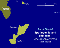
The Spafaryev Islands, or Spafaryev Island (Остров Спарафьева; Ostrov Spafar’yeva), a relatively large double island, are located in the Sea of Okhotsk. It lies 7 km east of the Antamlan Peninsula (also known as Khmitevsky), the southernmost peninsula enclosing the Taui Bay (Тауйская губа; Tauyskaya Guba) from its western side.
Administratively these islands belong to the Magadan Oblast of the Russian Federation.
Etymology
The Spafaryev Islands were named after Major General knight Leontiy Spafaryev (1765–1847) of the Imperial Russian Navy. Spafaryev was Director of the Lighthouse Administration and cartographer of the Russian Admiralty.[1]
Geography
The Spafaryev Islands are composed of two islands joined by a narrow landspit, less than 750 m wide.
- The northern “island”, Ryabokon Island (Ostrov Ryabokon’), is roughly triangular in shape. It is the larger of the two, being 9 km long and having a maximum width of 5 km.
- Spafaryev Island proper is located at the southern end. It is roughly shovel-shaped and is 7 km long and has a maximum width of 4.5 km.[2]
- Talan Island (Остров Талан) 59°18′N 149°05′E / 59.300°N 149.083°E, is a small roundish island, which lies 11 km to the north of Spafaryev's northern tip. It is 2 km across.[3][4][5]
References
External links
Coordinates: 59°10′N 149°03′E / 59.167°N 149.050°E