Southgate Road
Coordinates: 51°32′37″N 0°05′03″W / 51.543508°N 0.084237°W

Southgate Road is a street in London, England, that runs from Baring Street in the south to the junction with Mildmay Park and Ball's Pond Road in the north. The street forms a part of the B102 road, leading from Newington Green to The City. The west side of Southgate Road is in the London Borough of Islington; and the east side is in the London Borough of Hackney. Southgate Road lies north of the Regent's Canal, west of De Beauvoir Town and east of Essex Road.
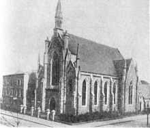
Joseph Stalin, Vladimir Lenin and Leon Trotsky visited Southgate Road for the 5th Congress of the Russian Social Democratic Labour Party in 1907, which was held at the Brotherhood Church which once stood on the corner of Southgate Road and Balmes Road. The site is now occupied by a mixed-use residential and business building, with the exact site of the church now a Tesco Express shop.
Today, a number of new developments are assisting in the regeneration of the area.
Transport
Southgate Road has three main bus routes that provide residents direct routes into the City and West end as well as the outer London areas.
- 21: Newington Green - Lewisham
- 76: Tottenham - Waterloo
- 141: Palmers Green - London Bridge station
Nearest London Underground stations:
- - Angel tube station
- - Old Street tube station
Nearest National Rail station:
- - Essex Road station
- - Highbury & Islington station
- - Old Street station
