Southern Emigrant Trail
- The Southern Emigrant Trail should not be confused with the Applegate Trail, which is part of the Northern Emigrant Trails.
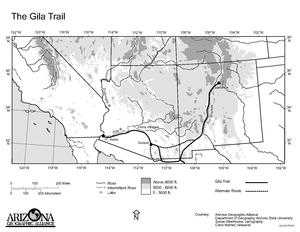
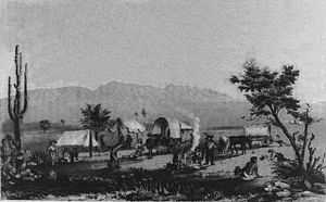
Southern Emigrant Trail, also known as the Gila Trail, the Kearny Trail, and the Butterfield Stage Trail, was a major land route for immigration into California from the eastern United States that followed the Santa Fe Trail to New Mexico during the California Gold Rush. Unlike the more northern routes, pioneer wagons could travel year round, mountain passes not being blocked by snows, however it had the disadvantage of summer heat and lack of water in the desert regions through which it passed in New Mexico Territory and the Colorado Desert of California. Subsequently it was a route of travel and commerce between the eastern United States and California. Many herds of cattle and sheep were driven along this route and it was followed by the San Antonio-San Diego Mail Line in 1857-1858 and then the Butterfield Overland Mail from 1858 - 1861.
History of the Route
In October 1846, General Stephen Watts Kearny and his dragoons with their scout Kit Carson found the route over the mountains from the El Camino Real de Tierra Adentro on the Rio Grande to the Gila River which he then followed to the Colorado River then crossed the Colorado Desert to Southern California. One month later, Colonel Philip St. George Cooke and the Mormon Battalion with wagons Kearny could not take across the mountains of New Mexico, followed a route from what later became the site of Fort Thorn on the Rio Grande, that reached far southwest to just south of the current border with Mexico then west before turning northward via the San Pedro River, then west to Tucson before linking up with and following Kearny’s route at the Pima Villages on the Gila River establishing the first southern wagon road to California. An expedition later in the Mexican War followed this wagon route to the Mexican border region but went farther west to turn north on the old Spanish road to Tucson along the Santa Cruz River. This wagon route became known as Cooke's Road, or Sonora Road, as much of the route passed through what was then the state of Sonora, Mexico.
The discovery of gold in California, brought a flood of Americans westward in 1849, many of the travelers from the southern states coming west on the San Antonio-El Paso Road and other routes used this route westward from the Rio Grande, crossing that river at the San Diego Crossing of the El Camino Real de Tierra Adentro, north of Doña Ana, to link up with Cooke's Road near what became the site of Fort Thorn. From this time on, it was called the Southern Trail or Southern Emigrant Trail.
Subsequently the distance of the route was shortened by the Tucson Cutoff pioneered by John Coffee Hays with a party of forty-niners in late 1849. This route avoided the long distance traveled to the south by passing through Stein's Pass, Apache Pass and Nugent’s Pass to the Lower Crossing of the San Pedro River near Tres Alamos. From there it linked up with Cooke's Road at a waterhole, near modern Mescal.[1][2]
In 1855, a Railroad Survey Expedition modified the cutoff route between the San Pedro River and Apache Pass passing south of Nugent's Pass using Dragoon Pass and the using the Middle Crossing or San Pedro Crossing of the river instead of the Lower Crossing below Los Alamos.[3] A military road route built following the Gadsden Purchase, added another shortening of the route, from Mesilla, New Mexico to Cooke's Spring shortening the route still further for travelers from the southern states.
The route from the 1857 to the 1880's
Tied in with the Santa Fe Trail and the San Antonio-El Paso Road, by the El Camino Real de Tierra Adentro, the Southern Emigrant Trail route ran from Fort Thorn or Mesilla to Los Angeles, California. From Mesilla it passed westward to Cooke's Spring then followed Cooke's Wagon Road and the Tucson Cutoff, to Tucson, Arizona, then turned northward to the Pima Villages and Maricopa Wells where it turned westward along the Gila River following it to the ferries on the Colorado River near what became Fort Yuma. From Fort Yuma it crossed the Colorado Desert, dipping south into Baja California, Mexico to follow the waterholes along the Alamo and New Rivers then northwest into California again across the desert to Carrizo Creek and the oasis at Vallecito. It then ran northwest into the Peninsular Ranges crossing Warners Pass to Warner's Ranch. From Warner's the road then ran either northwest to Los Angeles, (via Temecula, La Laguna, Temescal, Chino and San Gabriel) or west southwest to San Diego via Santa Ysabel, San Pasqual and Rancho Penesquitos.[4][5][6] From either of these towns the traveler could continue north by land to the gold fields on the coast via the El Camino Real or over the old Tejon Pass into the San Joaquin Valley and then north by what would later become the Stockton - Los Angeles Road or via the El Camino Viejo. Alternatively they could take ships to San Francisco from San Diego or San Pedro. This route remained a primary east west route in the southwest until the advent of the railroads in the 1880s.
References
- ↑ Robert Eccleston, Overland to California on the Southwestern Trail 1849, University of California Press, Berkeley, 1950, pp. 174-193
- ↑ Richard J. Hinton, The Handbook to Arizona: Its Resources, History, Towns, Mines, Ruins, and Scenery, Payot, Upham & Company, 1878 pp.xix-xx, xxxi
- ↑ REPORT OF CAPTAIN A. A. HUMPHREYS, TOPOGRAPHICAL ENGINEERS, Upon the progress of the Pacific Railroad Expeditions and Surveys, Report of the Secretary of War, Dec. 1, 1856, Message from the President of the United States to the Two Houses of Congress at the Commencement of the third session of the 34th Congress, 34th Congress, 3d Session, House of Repressentatives, Ex. Doc. No.1, Vol. II, Cornelius Wendell, Washington, 1856, pp.206-209
- ↑ Randolph B. Marcy, Captain U. S. Army, The Priarie Traveler. A Hand-Book For Overland Expeditions. With maps, illustrations, and itineraries of the Principal Routes between the Mississippi and the Pacific, Published by Authority of the War Department, New York, Harper & Brothers, Publishers, Franklin Square, 1859. List of Itineraries, XIV.—Wagon-road from San Antonia, Texas, to El Paso, N. M., and Fort Yuma, Cal.
- ↑ Marcy, The Priarie Traveler..., List of Itineraries, XV.—From Fort Yuma to San Diego, California.
- ↑ Marcy, The Priarie Traveler..., List of Itineraries, XXI.—From Fort Yuma to Benicia, California