South Roscoe Township, Hodgeman County, Kansas
| South Roscoe Township | |
|---|---|
| Township | |
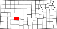
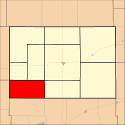 Location in Hodgeman County | |
| Coordinates: 37°57′26″N 100°07′01″W / 37.95722°N 100.11694°WCoordinates: 37°57′26″N 100°07′01″W / 37.95722°N 100.11694°W | |
| Country | United States |
| State | Kansas |
| County | Hodgeman |
| Area | |
| • Total | 71.33 sq mi (184.76 km2) |
| • Land | 71.31 sq mi (184.68 km2) |
| • Water | 0.03 sq mi (0.08 km2) 0.04% |
| Elevation | 2,572 ft (784 m) |
| Population (2000) | |
| • Total | 76 |
| • Density | 1.1/sq mi (0.4/km2) |
| GNIS feature ID | 0471630 |
South Roscoe Township is a township in Hodgeman County, Kansas, USA. As of the 2000 census, its population was 76.
Geography
South Roscoe Township covers an area of 71.33 square miles (184.7 km2) and contains no incorporated settlements. According to the USGS, it contains one cemetery, Saint Michaels.
The stream of South Fork Buckner Creek runs through this township.
References
External links
| |||||||||||||||||