South Road, Adelaide
| South Road South Australia | |
|---|---|
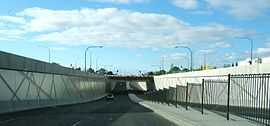 | |
| South Road Underpass beneath Anzac Highway | |
| General information | |
| Type | Road |
| Length | 115 km (71 mi) |
| Route number(s) |
|
| Major junctions | |
| North end |
|
Yankalilla-Victor Harbor Road | |
| South end |
via Ferry to Kangaroo Island |
| Location(s) | |
| Major suburbs | Croydon, Hindmarsh, Mile End, Reynella, Morphett Vale, Old Noarlunga, Aldinga, Sellicks Hill, Yankalilla |
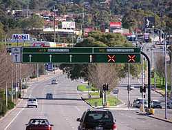
South Road (route A13, B23) is a major north–south conduit in Adelaide, South Australia. Also known as Main South Road, it is Adelaide's most important arterial road.
Route
South Road carries much of the road traffic from the southern suburbs towards the Adelaide city centre. This traffic completes its journey to the city centre via Anzac Highway.
From Anzac Hwy, South Road continues north as a western bypass of the city across many arterials, the major ones being Port Road, Regency Road and Grand Junction Road, to the junctions with the Port River Expressway and the Salisbury Highway. Until the Port River Expressway opened in 2005, the sections of South Road and Salisbury Highway between Grand Junction Road and Port Wakefield Road were known as the South Road Extension, built in the early 1990s.
To the south of Anzac Hwy, the name changes to Main South Road at the intersection of Ayliffes and Shepherds Hill Roads at Clovelly Park, and continues through Seaford (where the Victor Harbor road branches off) and runs parallel to the west coast of Fleurieu Peninsula all the way to Normanville where it become Willis Drive for 2 km where it becomes Main South Road until Cape Jervis at its southern tip. The town of Old Noarlunga, South Australia was bypassed in 1972,[1] and Old Reynella in 1964.[2] The fully reversible Southern Expressway (M2) runs roughly parallel to South Road for 18 km from Darlington to Noarlunga and carries through traffic to reduce peak congestion. Main South Road and the Southern Expressway have 3 different intersections along the length of the roads.
Congestion and upgrades
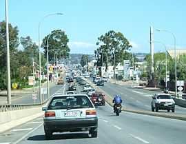
South Road suffers from traffic congestion due to its importance as Adelaide's main arterial road. Traffic has also increased in line with the growth and development of Adelaide's southern suburbs.
An overpass was built over Cross Road and the train line between 1982 and 1984 to reduce a major bottleneck.
The State government completed an underpass "Gallipoli Underpass" at Anzac Highway, and an overpass of the Adelaide-Glenelg tramway, in 2009 and 2010. The underpass model used is a diamond interchange. Plans to construct a tunnel under Grange Road, Port Road and the Outer Harbor–Grange railway line, and upgrade of the stretch between Port Road and Torrens Road, a particularly sub-standard section of South Road, have been put "on hold" until after completion of the Superway (see below).
In November 2005, the Royal Automobile Association (RAA) released their recommendations to the South Australian government in regards to the road network. South Road was found to be the poorest road in the state, registering a 2/10 on the RAA's scale. The recommendations given included $6 billion of funds to upgrade the roads of South Australia – with $1.5–2 billion to be spent on South Road alone. The RAA's plan for the road included a 6 km tunnel from Port Road all the way to the Anzac Highway underpass and over/underpasses at six other major intersections and two rail crossings. PDF
On 18 August 2007, the then Prime Minister John Howard announced that South Road was to be included in the AusLink National Road Network, and also pledged $1 billion in funding for the project between 2007 and 2020.[3]
In October 2009, both the Premier of South Australia and the Prime Minister of Australia released plans for the South Road Superway- a 3–4 km section of elevated freeway running from the Port River Expressway to the intersection of Regency Road at a cost of $800million. The project started in 2010 and should be completed by 2014. The elevated part will avoid crossing Grand Junction, Cormack Roads, and the Port Adelaide-Dry Creek railway. Unfortunately, this will duplicate what is already one of the best parts of South road, (3 lanes each direction), while other parts remain in urgent need of an upgrade, (between Port and Regency roads, for example).
Major intersections (north–south)
| South Road / Main South Road | |||
| Southbound | Northbound | ||
| Start South Road from Salisbury Highway |
End South Road continues as Salisbury Highway to | ||
| no access. | Port River Expressway | ||
| PORT FLAT FREIGHT RAIL LINE grade separation in progress [4] |
PORT FLAT FREIGHT RAIL LINE grade separation in progress [4] | ||
| Cormack Road grade separation in progress [4] |
Cormack Road grade separation in progress [4] | ||
| Grand Junction Road National grade separation in progress [4] |
Grand Junction Road State grade separation in progress [4] | ||
| Days Road grade separation in progress [4] |
Days Road grade separation in progress [4] | ||
| Regency Road |
Regency Road | ||
| Torrens Road |
Torrens Road | ||
| OUTER HARBOR RAIL LINE | OUTER HARBOR RAIL LINE | ||
| Port Road |
Port Road | ||
| Manton Street |
Grange Road | ||
| Henley Beach Road |
Henley Beach Road | ||
| Sir Donald Bradman Drive |
Sir Donald Bradman Drive | ||
| Richmond Road |
Richmond Road | ||
| Anzac Highway |
Anzac Highway | ||
| GLENELG TRAM LINE |
GLENELG TRAM LINE | ||
| Cross Road/NOARLUNGA RAIL LINE |
Cross Road/NOARLUNGA RAIL LINE | ||
| Daws Road |
Daws Road | ||
| Ayliffes Road Northbound |
no exit. | ||
| Shepherds Hill Road Eastbound |
no exit. | ||
| Sturt Road grade separation proposed [6] |
Sturt Road grade separation proposed [6] | ||
| Flinders Drive Eastbound |
Only Eastbound Access to FMC. | ||
| no access. | Southern Expressway Southbound Entry Only | ||
| Flagstaff Road |
Marion Road | ||
| no exit. | Majors Road Westbound | ||
| Black Road Eastbound |
no exit. | ||
| Chandlers Hill Road Eastbound |
no exit. | ||
| Panalatinga Road |
Southern Expressway Northbound Entry Only | ||
| Pimpala Road Eastbound |
Sherriffs Road Westbound | ||
| Bains Road Eastbound |
O'Sullivan Beach Road Westbound | ||
| Wheatsheaf Road Eastbound |
Flaxmill Road Westbound | ||
| Doctors Road Eastbound |
Beach Road Westbound | ||
| no exit. | Honeypot Road Westbound | ||
| Pennys Hill Road Eastbound |
Local Access Only. | ||
| no access. | Southern Expressway | ||
| Victor Harbor Road |
Victor Harbor Road | ||
| Start Route Continues as Main South Road to Cape Jervis |
End Route Continues as Route | ||
Gallery
-
Looking south from the Cross Road Overpass, Edwardstown.
-
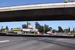
South Road overpass at Cross Road / Emerson Station.
See also
References
- ↑ Old Noarlunga
- ↑ Local Studies. Former Cricketers-Retrieved 24/01/2012
- ↑ Media Releases
- ↑ 4.0 4.1 4.2 4.3 4.4 4.5 4.6 4.7 "Transport SA. South Road Superway". Retrieved 2012-01-24.
- ↑ 5.0 5.1 "Glenelg Tram Overpass". South Australian Department for Transport, Energy and Infrastructure. 2008-06-19. Retrieved 2009-03-28.
- ↑ 6.0 6.1 "BUDGET: Transport infrastructure investment". Premier & Ministers of South Australia. 2006-09-21. Retrieved 2009-03-28.
| |||||||||||||||||||||||||