South Oakdale Historic District
|
South Oakdale Historic District |
|
|
|
|
 |
|
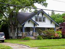
The district's Beeson House (1926) in 2013 |
|
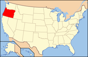
The South Oakdale Historic District boundaries in Medford |
| Location |
Medford, Oregon, roughly along S. Oakdale Avenue from Stewart Avenue to W. 10th Street[1] |
|---|
| Coordinates |
42°18′58″N 122°52′28″W / 42.316212°N 122.874438°W / 42.316212; -122.874438Coordinates: 42°18′58″N 122°52′28″W / 42.316212°N 122.874438°W / 42.316212; -122.874438 |
|---|
| Area |
Approx. 32 acres (13 ha)[1] |
|---|
| Built |
1890–1940 |
|---|
| Architect |
Frank Chamberlain Clark, Robert Keeney, D. R. Patrick, Barrett and Logan, others[1] |
|---|
| Architectural style |
Queen Anne, Bungalow, Colonial Revival, Tudor Revival, Romanesque Revival, other period revivals, Modernistic, others[1] |
|---|
| Governing body |
various |
|---|
| NRHP Reference # |
79002072 |
|---|
| Added to NRHP |
March 15, 1979 |
|---|
The South Oakdale Historic District comprises a primarily residential area along South Oakdale Avenue in Medford, Oregon, United States. Development of this well-preserved residential neighborhood began in 1890, soon after Medford's founding in 1883, and continued until around 1940. It became one of the city's grand neighborhoods, with many residents prominent in land development, business, agriculture, law, medicine, education, politics, and the arts. The district exhibits a wide range of architectural styles from its period of development, notably including several works by Frank Chamberlain Clark, southern Oregon's preeminent architect of the early 20th century.[1]
The district was added to the National Register of Historic Places in 1979.[2]
See also
References
External links
|
|---|
| | List | |
|---|
| | Historic districts | |
|---|
| | Properties |
- Nils Ahlstrom House
- Thomas N. Anderson House
- Antelope Creek Bridge
- Ashland Cemetery
- Ashland Depot Hotel, South Wing
- Ashland Downtown Historic District
- Ashland Masonic Lodge Building
- Ashland Municipal Powerhouse
- Ashland Oregon National Guard Armory
- Ashland Railroad Addition Historic District
- W. H. Atkinson House
- Sophenia Ish Baker House
- Barclay–Klum House
- Barnum Hotel
- Baldwin Beach House
- Robert Vinton Beall House
- Beeson–Foss Ranch
- Big Elk Guard Station
- Boslough–Claycomb House
- Walter Bowne House
- BPOE Lodge No. 1168
- Buckhorn Mineral Springs Resort
- Victor and Bertha Bursell House
- Butte Falls Ranger Station
- Frank E. Bybee House
- William Bybee House
- Richard Posey Campbell House
- A. S. V. Carpenter and Helen Bundy House
- E. V. Carter House
- H. B. Carter House
- Carter–Fortmiller House
- Central Point Public School
- Chappell–Swedenburg House
- Chavner Family House
- Citizen's Banking & Trust Co. Building
- Frank Chamberlain Clark House
- Cooley–Neff Warehouse
- Orlando Coolidge House
- Corning Court Ensemble
- Dead Indian Soda Springs Shelter
- E. Raymond Driver House
- Patrick Dunn Ranch
- Dutchman Peak Lookout
- Eddings–Provost House
- Eden Valley Orchard
- H. Chandler and Alice B. Egan House
- Enders Building
- Edward Charles Faber House
- First Baptist Church (Ashland, Oregon)
- First National Bank, Vaupel Store and Oregon Hotel Buildings
- Fish Lake Shelter
- Fluhrer Bakery Building
- Fort Lane Military Post Site
- Andrew J. Fredenburg House
- C. E. "Pop" Gates House
- Glenview Orchard Ensemble
- Gold Hill High School
- G. M. and Kate Grainger House
- Edgar F. Hafer House
- Michael Hanley Farmstead
- Hanscom Hall
- Hargadine Cemetery
- Charles and Elizabeth Hatch House
- Hillcrest Orchard Historic District
- George A. Hover House
- Imnaha Guard Station
- IOOF Building (Ashland, Oregon)
- Jackson County Courthouse (Medford, Oregon)
- Jacksonville Historic District (Jacksonville, Oregon)
- Jacksonville-to-Fort Klamath Military Wagon Road
- E. C. Kane House
- Liberty Building (Medford, Oregon)
- Lithia Park
- Lithia Springs Hotel (Ashland, Oregon)
- Lodgepole Guard Station
- Lost Creek Bridge
- Robert and Ruth Lucas House and Mary E. Rose House
- Madden–McCaskey House
- John McCall House
- William McCredie House
- McKee Bridge
- McKee Bridge Campground
- Patrick F. McManus House
- Medford Carnegie Library
- Medford Central Firehall
- Medford Downtown Historic District
- Medford Geneva–Minnesota Historic District
- Medford Grocery Company Warehouse
- Medford IOOF Cemetery
- Medford Plaza Apartments
- Medford Southern Pacific Railroad Passenger Depot
- John W. Merritt House and Store
- Mountain House (Ashland, Oregon)
- Mountain View Cemetery (Ashland, Oregon)
- Mt. Stella Lookout
- Amos and Vera Nininger House
- John Orth House
- Parker Meadows Shelter
- Reginald Parsons Dead Indian Lodge
- Hamilton and Edith Patton House
- S. and Sarah J. Pedigrift House
- Peerless Rooms Building
- Emil and Alice Applegate Peil House
- John and Charlotte Pelton House
- Domingo Perozzi House
- Dr. E.B. Pickel Rental House
- Humboldt Pracht House
- Prospect Hotel
- Putnam–Neff House
- Alfred Evan Reames House
- Dr. John F. and Mary Reddy House
- Rich Gulch Diggings
- Rock Point Hotel
- Rogue Elk Hotel
- Root–Banks House
- Fordyce Roper House – Southern Oregon Hospital
- Schuler Apartment Building
- Shone–Charley House
- Col. William H. Silsby House
- Siskiyou–Hargadine Historic District
- Skidmore Academy Historic District
- Snowy Butte Flour Mill
- South Oakdale Historic District
- Sparta Building
- Squaw Peak Lookout
- Star Ranger Station
- Star Ranger Station Building, Old
- Dr. Charles T. and Mary Sweeney House
- Talent Elementary School
- George Taverner House
- Tayler–Phipps Building
- Trinity Episcopal Church (Ashland, Oregon)
- U.S. Post Office and Courthouse (Medford, Oregon)
- Union Creek Historic District
- Henry Van Hoevenberg, Jr., House
- Wagner Creek School
- John P. Walker House
- Washington Elementary School (Medford, Oregon)
- Mathias Welch House
- West Side Feed and Sale Stable
- Whaleback Snow-Survey Cabin
- John B. White House
- Harry L. Whited House
- Whittle Garage Building
- Wilkinson–Swem Building
- Willow Prairie Cabin
- Women's Civic Improvement Clubhouse
- Isaac Woolen House
- Wrangle Gap Shelter
|
|---|
| | Formerly listed |
- David N. Birdseye House
- Cargill Court Apartments
- Samuel Colver House
- Conro Fiero House
- Medford Hotel
- Wimer Bridge
|
|---|
|


 Media related to South Oakdale Historic District at Wikimedia Commons
