South Hanningfield
| South Hanningfield | |
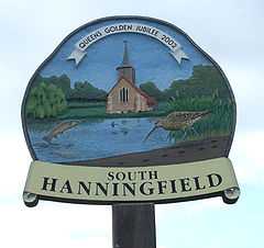 Village sign |
|
 South Hanningfield |
|
| OS grid reference | TQ743976 |
|---|---|
| Civil parish | South Hanningfield |
| District | Chelmsford |
| Shire county | Essex |
| Region | East |
| Country | England |
| Sovereign state | United Kingdom |
| Post town | CHELMSFORD |
| Postcode district | CM3 8 |
| Dialling code | 01268 |
| Police | Essex |
| Fire | Essex |
| Ambulance | East of England |
| EU Parliament | East of England |
| UK Parliament | Rayleigh |
| Website | South Hanningfield village |
Coordinates: 51°39′01″N 0°31′06″E / 51.6504°N 0.5183°E
South Hanningfield is a small village and civil parish[1] in south Essex, England. It is located approximately 10 km (6.2 mi) south-southeast of the county town of Chelmsford, and approximately 5 km (3 mile north-northeast of Wickford. The village is in the borough of Chelmsford and in the parliamentary constituency of Rayleigh.
The village is by Hanningfield Reservoir. South Hanningfield has approximately 100 households.[2] .[3]
The centre of the village is situated around the Tye (village green). The village sign is located here. The Tye is on the road junction of South Hanningfield Road, which runs from Downham to Rettendon Common and Middlemead which leads to West Hanningfield.
The village contains a village hall, and is home to the Old Windmill pub.
The civil parish includes Downham and the largest village of the parish, Ramsden Heath.
See also
- Hanningfield reservoir
- East Hanningfield
- West Hanningfield
- Lord Hanningfield
References
- ↑ "Parish Councils". www.chelmsford.gov.uk. October 2006. Retrieved 2007-03-14.
- ↑ "Statistics". www.ramsdenheath.info. Retrieved 2007-03-14.
- ↑ "Statistics". www.ramsdenheath.com. Retrieved 2007-03-14.
External links
![]() Media related to South Hanningfield at Wikimedia Commons
Media related to South Hanningfield at Wikimedia Commons
| ||||||||||||||||||||||