South Fork Solomon River
| South Fork Solomon River | |
| River | |
| Country | United States |
|---|---|
| State | Kansas |
| Source | |
| - location | Sherman County, Kansas |
| - coordinates | 39°14′45″N 101°26′46″W / 39.24583°N 101.44611°W [1] |
| Mouth | Waconda Lake |
| - location | Mitchell County, Kansas |
| - elevation | 1,457 ft (444 m) |
| - coordinates | 39°28′23″N 98°26′00″W / 39.47306°N 98.43333°WCoordinates: 39°28′23″N 98°26′00″W / 39.47306°N 98.43333°W [1] |
| Length | 292 mi (470 km) |
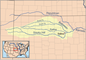 Map of the Smoky Hill River drainage basin showing the Solomon River including the north and south forks
| |
The South Fork Solomon River is a 292-mile-long (470 km)[2] river in the central Great Plains of North America. The entire length of the river lies in the U.S. state of Kansas. It is a tributary of the Solomon River.
Geography
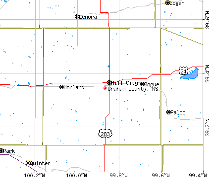
The South Fork Solomon River rises in Sherman County, Kansas, and flows eastward through Thomas and Sheridan counties into Graham County.
The South Fork Solomon River travels across Graham County roughly following the course of Highway 24. The South Fork Solomon River enters Graham County about ½ mile (0.8 km) south of Studley and exits Graham County about 5 miles (8.0 km) southwest of Nicodemus. The river runs though Bogue, Hill City, Penokee, Morland and Studley, and is impounded a few miles west of Solomon, Kansas in Rooks County to form the large Webster Reservoir.
The river then joins the North Fork Solomon River at Waconda Lake in northwestern Mitchell County, forming the Solomon River.[1]
See also
References
- ↑ 1.0 1.1 1.2 U.S. Geological Survey Geographic Names Information System: South Fork Solomon River. Retrieved on 2008-07-22.
- ↑ U.S. Geological Survey. National Hydrography Dataset high-resolution flowline data. The National Map, accessed March 29, 2011
External links
- Graham County map at City-Data.com
- About the Solomon Valley at the Solomon Valley Highway 24 Heritage Alliance