South Field (Iwo Jima)
South Field (Iwo Jima).png) Motoyama No. 1 Chidori Field | |
|---|---|
| Part of Twentieth Air Force | |
|
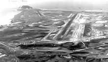
South Field, Iwo Jima, February 1945 | |
| Coordinates | 24°45′46″N 141°18′13″E / 24.76278°N 141.30361°E |
| Type | Military Airfield |
| Site information | |
| Controlled by | United States Army Air Forces |
| Site history | |
| Built | Prior to 1944 |
| In use | 1944–1955 |
South Field was a World War II airfield on Iwo Jima in the Volcano Islands, located in the Central Pacific. The Volcano Islands are part of Japan. The airfield was located on the southern corner of Iwo Jima located on the Motoyama plateau, to the north of Mount Suribachi. South Field was significant to the overall Battle of Iwo Jima.
History
Built by the Japanese, the base included three intersecting runways. On 2 January 1944, more than a dozen B-24 Liberator bombers raided Airfield No. 1 and inflicted heavy damage. Commander of the island, Lieutenant General Tadamichi Kuribayashi diverted more than 600 men, 11 trucks, and 2 bulldozers for immediate repairs. As a result, the airfield again became operational after only twelve hours.[1] It was used by the Japanese until 19 February 1945 when the United States Marines landed on the island. It was during the fight to secure this airfield that Medal of Honor recipient Gunnery Sergeant John Basilone was killed by a Japanese mortar shell.
The airfield became a battlefield during the Battle of Iwo Jima. It was put into action by the Americans as the battle still raged. At South Field, the east-northeast to west-southwest runway was being used by observation planes as early as 26 February (D plus 7) when the first American aircraft landed on the strip, an OY-1 Sentinel piloted by Lt. Harvey Olson of VMO-4. By 2 March the runway had been graded to 4,000-feet (1,219-meters). Later, on 4 March with the battle still raging a B-29 Superfortress named Dinah Might from the 9th Bombardment Group (Very Heavy) landed, the first of 2,400 emergency landings by American aircraft at South Field and North Field on Iwo Jima.[2]
On 9 March, this airfield paid its first dividend when a B-29 in distress came in for an emergency landing. Two days later the Twentieth Air Force P-51 Mustangs of the 15th and 21st Fighter Groups came up from Saipan for long-range B-29 fighter escort operations. From then on, South Field was in constant use while construction was continued.
On 16 March, US Navy PB4Y-1's (Navy version of the B-24) patrol bombers of VPB-116 arrived at this airfield from Tinian. The patrol bombers performed various missions from South Field through the remainder of the war. The PB4Y-1 were later relieved by PB4Y-2 aircraft.
On 7 April 1945, P-51s took off from South Field to form the first land-based fighter escort for B-29s on a strike against the Japanese homeland. By July, the runway had been extended to 6,000-by-200-feet (1,829-by-61-meters) and had been surfaced with emulsified asphalt. Also constructed were 7,950-feet (2,423-meters) of taxiways and 258 hardstands. This field could accommodate 100 P-51s and 30 B-24 Liberators. In an emergency, B-29s could land here. Fighter escort operations took place from March until November 1945.

After the war, the 20th Air Force fighter squadrons moved out to Japan, Okinawa or the Philippines and South Field came under the Jurisdiction of Military Air Transport Service (MATS), becoming a refueling stop for MATS aircraft in the Western Pacific. It hosted various communications, weather as well as Far East Materiel Command units for supply and maintenance activities. It was under the command of the Iwo Jima Base Command, as a satellite of the 6000th Support Wing, Tachikawa Air Base, Japan. It was likely classified as a remote assignment for military personnel, as other than rudimentary medical and personnel living facilities, no family housing or other quality of life facilities were built to accommodate families for accompanied tours.
The USAF 6415th Air Base Squadron garrisoned the base until turning over the facility to the Japanese government on 30 September 1955.[3] Today most traces of the airfield have been removed, and natural vegetation has taken over the landscape. Possibly some small roads remain which are still in use.
See also
Notes
References
![]() This article incorporates public domain material from websites or documents of the Air Force Historical Research Agency.
This article incorporates public domain material from websites or documents of the Air Force Historical Research Agency.
- Bibliography
- Hammel, Eric (2006). Iwo Jima: Portrait of a Battle: United States Marines at War in the Pacific. St. Paul, Minn.: Zenith Press. ISBN 0760325200. OCLC 69104268.
- Maurer, Maurer (1983). Air Force Combat Units Of World War II. Maxwell AFB, Alabama: Office of Air Force History. ISBN 0892010924.
- Web
External links
| |||||||||||||||||||||||||||||||||||||||||||
