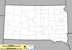
South Dakota Highway 21
| ||||
|---|---|---|---|---|
|
Route of SD 21 (in red) | ||||
| Route information | ||||
| Defined by SDCL §31-4-146 | ||||
| Maintained by SDDOT | ||||
| Length: | 9.465 mi[1] (15.232 km) | |||
| Existed: | 1926 – present | |||
| Major junctions | ||||
| South end: |
| |||
| North end: |
| |||
| Location | ||||
| Counties: | Hamlin | |||
| Highway system | ||||
| ||||
South Dakota Highway 21 (SD 21) is a short state route in east central South Dakota. The southwest end is located at the junction with South Dakota Highway 28 on the west edge of Lake Norden. After running northward to Hayti, it is routed east to end at the junction with U.S. Highway 81. It is 9.5 miles (15 kilometers) in length.
Route description
SD 21 begins at an intersections with SD 28 in the city of Lake Norden. From SD 28, it heads north past the western shores of Lake Norden. The highway makes a short jog to the east and then continues north towards Hayti. Through Hayti, the highway passes within feet of the eastern shore of Lake Marsh. At Redbird Street in Hayti, SD 21 turns to the east for the remainder of its route. It ends at U.S. Route 81 about 4 miles (6.4 km) east of Hayti.
History
The original South Dakota 21 was in place when the U.S. highway system was implemented in 1926. At that time, U.S. Highway 81 was assigned to the route of SD 21, and both numbers shared the road. When U.S. 81 in this area was rerouted a few miles east, SD 21 was kept on the old alignment, and has remained in place since.
Major intersections
The entire route is in Hamlin County.
| Location | mi[1] | km | Destinations | Notes | |
|---|---|---|---|---|---|
| Lake Norden | 0.000 | 0.000 | |||
| 9.465 | 15.232 | ||||
| 1.000 mi = 1.609 km; 1.000 km = 0.621 mi | |||||
References
- ↑ 1.0 1.1 "State Highway Log" (PDF). Aberdeen region: South Dakota Department of Transportation. January 2011. p. 76. Retrieved December 22, 2011.
External links
Route map: Bing

