South Bay (Livingston Island)

Location of Livingston Island in the South Shetland Islands.
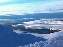
South Bay from Lyaskovets Peak.

Topographic map of Livingston Island, Greenwich, Robert, Snow and Smith Islands.
South Bay (62°40′S 60°28′W / 62.667°S 60.467°WCoordinates: 62°40′S 60°28′W / 62.667°S 60.467°W) is a 11.6 kilometres (7.2 mi) wide bay indenting for 12.5 kilometres (7.8 mi) the south coast of Livingston Island in the South Shetland Islands, Antarctica. The bay is lying northwest of False Bay and east of Walker Bay, and is entered between Hannah Point and Miers Bluff.
South Bay was known to both American and British sealers as early as 1820, and the name has been well established in international usage for over 100 years.
Maps
- L.L. Ivanov et al. Antarctica: Livingston Island and Greenwich Island, South Shetland Islands. Scale 1:100000 topographic map. Sofia: Antarctic Place-names Commission of Bulgaria, 2005.
- L.L. Ivanov. Antarctica: Livingston Island and Greenwich, Robert, Snow and Smith Islands. Scale 1:120000 topographic map. Troyan: Manfred Wörner Foundation, 2009. ISBN 978-954-92032-6-4
References
![]() This article incorporates public domain material from the United States Geological Survey document "South Bay (Livingston Island)" (content from the Geographic Names Information System).
This article incorporates public domain material from the United States Geological Survey document "South Bay (Livingston Island)" (content from the Geographic Names Information System).